
Now Reading: Patagonia Glacier retreat, Chile
1
-
01
Patagonia Glacier retreat, Chile


before
after
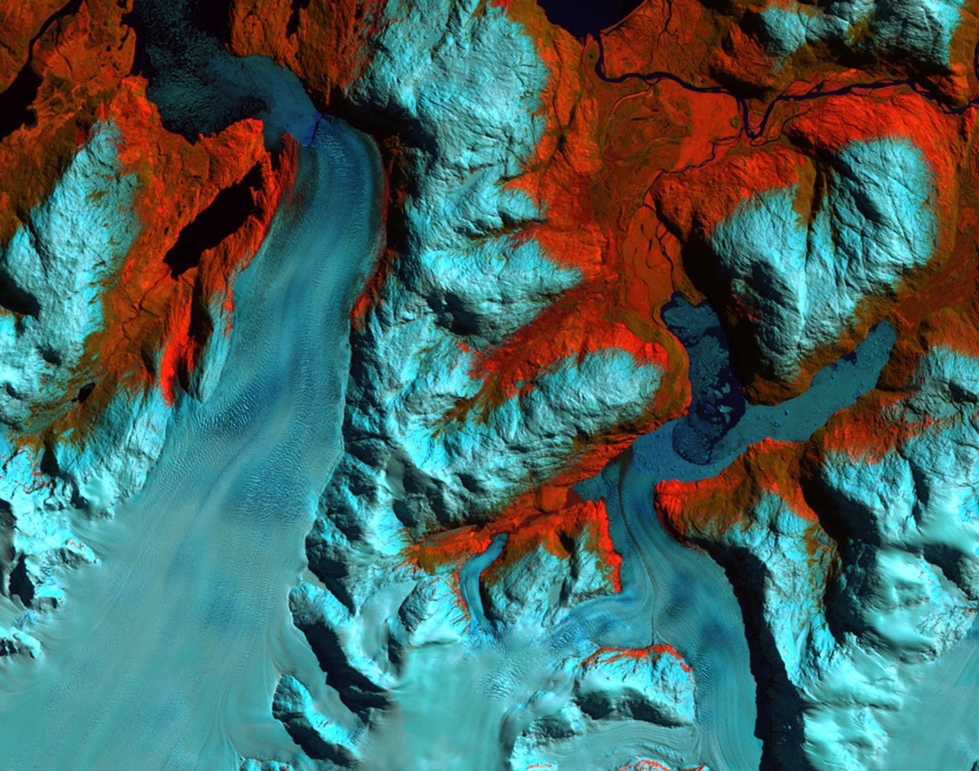
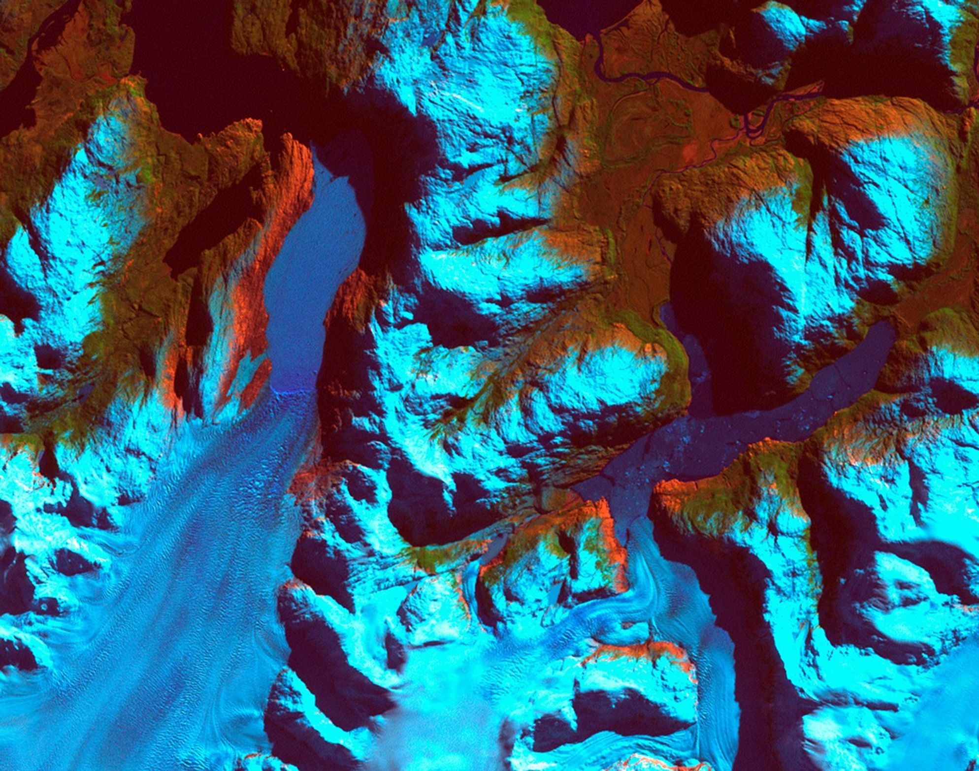
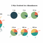
Patagonia, Chile. Left: September 18, 1986. Right: August 5, 2002. The 1986 image shows the region prior to a major retreat of the glaciers. The 2002 image shows a retreat of nearly 10 kilometers (6.2 miles) of the glacier on the left side. The smaller glacier on the right has receded more than 2 kilometers (1.2 miles). In front of the smaller glacier, two ribbon lakes have formed behind the debris left by the glacier’s advance. Scientists and government managers are using satellite imagery like this to monitor the retreat of the glaciers and the impact on water bodies caused by the changes in the glaciers’ size and direction. Left image taken by the Thematic Mapper sensor onboard Landsat 5. Right image taken by the Enhanced Thematic Mapper Plus sensor onboard Landsat 7. Source: USGS Landsat Missions Gallery, “Patagonia Region – Retreating Glaciers,” U.S. Department of the Interior / U.S. Geological Survey.
NASA/USGS
Before and After
Patagonia Glacier retreat, Chile
September 18, 1986 – August 5, 2002
Patagonia, Chile. Left: September 18, 1986. Right: August 5, 2002. The 1986 image shows the region prior to a major retreat of the glaciers. The 2002 image shows a retreat of nearly 10 kilometers (6.2 miles) of the glacier on the left side. The smaller glacier on the right has receded more than 2 kilometers (1.2 miles). In front of the smaller glacier, two ribbon lakes have formed behind the debris left by the glacier’s advance. Scientists and government managers are using satellite imagery like this to monitor the retreat of the glaciers and the impact on water bodies caused by the changes in the glaciers’ size and direction. Left image taken by the Thematic Mapper sensor onboard Landsat 5. Right image taken by the Enhanced Thematic Mapper Plus sensor onboard Landsat 7. Source: USGS Landsat Missions Gallery, “Patagonia Region – Retreating Glaciers,” U.S. Department of the Interior / U.S. Geological Survey.


Related Posts


Stay Informed With the Latest & Most Important News
[mc4wp_form id=314]


Advertisement
Loading Next Post...
Popular Now
-
 01Two Black Holes Observed Circling Each Other for the First Time
 -
 02From Polymerization-Enabled Folding and Assembly to Chemical Evolution: Key Processes for Emergence of Functional Polymers in the Origin of Life
 -
 03Astronomy 101: From the Sun and Moon to Wormholes and Warp Drive, Key Theories, Discoveries, and Facts about the Universe (The Adams 101 Series)
 -
 04True Anomaly hires former York Space executive as chief operating officer
 -
 05Φsat-2 begins science phase for AI Earth images
 -
 06Hurricane forecasters are losing 3 key satellites ahead of peak storm season − a meteorologist explains why it matters
 -
 07Binary star systems are complex astronomical objects − a new AI approach could pin down their properties quickly
Scroll to Top