
Now Reading: Curiosity Blog, Sols 4661-4667: Peaking Into the Hollows
-
01
Curiosity Blog, Sols 4661-4667: Peaking Into the Hollows


5 min read
Curiosity Blog, Sols 4661-4667: Peaking Into the Hollows

By Susanne P. Schwenzer, Professor of Planetary Mineralogy at The Open University, UK
Earth planning date: Friday, Sept. 19, 2025
Curiosity is currently driving along the ridges of a very uneven terrain. One of the bigger ridges we nicknamed “Autobahn,” which is the German word for a highway. But the rover didn’t stay on that autobahn, now more officially named “Arare,” for very long. Instead it went on a trip along several of the smaller ridges and even into some hollows. You can get a good impression of the landscape in the image above, or view a wider panorama image here.
Today, I was science operations working group (SOWG) chair, the one responsible for coordinating all the science planning and making sure we stay within power and data budgets. As we have so much to do with imaging ridges and hollows, and the team members are also keeping APXS and LIBS busy planning to investigate the chemistry of the ridge tops, the sides of the ridges, and of course the rocks within the hollows, the demands on power and data volume are high. Alongside the “geo” observations, we are still in aphelion cloud season and want to make sure we capture enough atmospheric and environmental observations, too. In each plan, the DAN instrument and MARDI camera are regularly looking down. DAN informs us about hydrogen in the subsurface underneath the rover, which is most likely associated with water-bearing minerals. MARDI is documenting the rocks underneath the rover, more precisely underneath the left-front wheel.
With so many demands, and the fact that we are just coming out of Martian winter, where cold temperatures demand more heating to keep the rover safe, there was lots of demand on the power budgets all of this week. Thus, myself and my SOWG chair colleagues had many discussions to facilitate. What amazes me each time about our team, though, is how smoothly those discussions go and how deep an understanding we all have developed about the seasonality and cadence of each other’s investigations. It is so nice to see how smooth it has become to — as a team — figure out what has the highest priority on a given planning day.
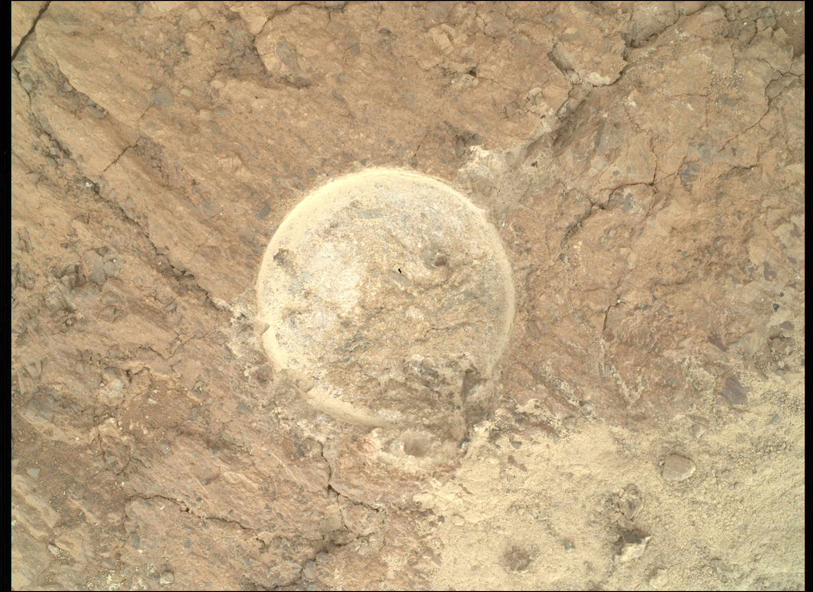
After a range of good discussions, and luck that the rover was parked in a stable position for each planning cycle, we had many arm activities. APXS and MAHLI focused on measuring and imaging the ridge tops — we call them bedrock — and those bedrocks look very smooth on top of the ridges. Targets “Turbio,” “Río Aguas Blancas,” and “Isiboro” were measured and imaged earlier in the week, and today it was “Colonia Santa Rosa” and “Le Lentias.” (I am learning Spanish as we go; all those names are from the Uyuni region in South America.) We entered the Uyuni quadrangle on sol 4573; you can read all about it in the blog post, ‘Welcome to the Uyuni Quad.’ More chemistry investigations were added by ChemCam using the LIBS instrument on a wide range of smoother bedrock, complementing APXS observations in many places, and then adding chemical information from locations that have more variable features such as veins, nodules and fractures.
Mastcam and ChemCam, through its remote imager, are taking images of many different features in the landscape. You can see its variation in the image at the top of the blog. What we are interested in is the variability of all those features, but also how they relate to each other. Are some features always on top of others, or are the veins cutting across the fractures? Those are the questions that we can answer with the images taken from a distance for the wider context, and then close-up to see all the details. We have taken overview images such as the one in the image above, and we have taken close-up images with the remote micro-imager and, of course, MAHLI. Many of those images come from the sides of the ridges as this allows us to see “into” the rock record, and how the ridges are constructed. If you look at the image above closely, you can see some of this yourself. You can spot some patterns, too. The ridge tops are more smooth, mostly at least. And that’s how the “Autobahn” was nicknamed in the first place! The hollows look more rough and a little more chaotic, too.
With all the excitement about the rocks, we didn’t forget the environmental observations. Those include temperature and wind, but also imaging of the atmosphere for its opacity and looking for dust devils. We are just coming out of the season with the least dust in the atmosphere. That allowed us to do a first for the mission: image rocks outside the crater rim, 90 kilometers away (about 56 miles)! We are very excited about those images taken with the remote micro-imager of ChemCam and with added Mastcam context. They show what’s beyond the crater rim, and what will have been the source region for some of the sediments we saw very early in the mission, when we explored the Peace Vallis Fan! Have a look at the wide overview image, and this close-up of rocks, 90 kilometers away, with the remote micro-imager.

Share
Details
Related Terms
Explore More


Related Posts


Stay Informed With the Latest & Most Important News
Previous Post
Next Post


Advertisement
-
 01Two Black Holes Observed Circling Each Other for the First Time
 -
 02From Polymerization-Enabled Folding and Assembly to Chemical Evolution: Key Processes for Emergence of Functional Polymers in the Origin of Life
 -
 03Astronomy 101: From the Sun and Moon to Wormholes and Warp Drive, Key Theories, Discoveries, and Facts about the Universe (The Adams 101 Series)
 -
 04True Anomaly hires former York Space executive as chief operating officer
 -
 05Φsat-2 begins science phase for AI Earth images
 -
 06Hurricane forecasters are losing 3 key satellites ahead of peak storm season − a meteorologist explains why it matters
 -
 07Binary star systems are complex astronomical objects − a new AI approach could pin down their properties quickly