
Now Reading: Sea-level monitoring satellite unboxed
-
01
Sea-level monitoring satellite unboxed


01/10/2025
249 views
4 likes
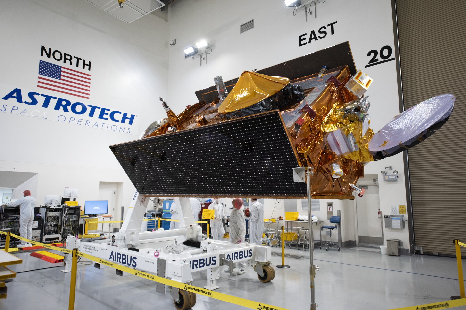
Following its arrival in California a few weeks ago, the time has come for spacecraft engineers to ready the next sea-level monitoring satellite, Copernicus Sentinel-6B, for launch, which is slated for November.
The first step has been to carefully remove this precious new satellite from its storage container and to start a series of comprehensive checks.
Sentinel-6B is set to carry forward the legacy of Sentinel-6 Michael Freilich – the first Sentinel-6 satellite, launched in November 2020. The Sentinel-6 mission serves as the world’s primary reference mission for radar altimetry to extend the continuous record of sea-surface height measurements that began in the early 1990s by the French–US Topex Poseidon satellite and then by the Jason series of satellite missions.
With sea-level rise high on the global agenda, numerous organisations have worked to make Copernicus Sentinel-6 the gold-standard reference mission for extending the record of sea-surface height measurements – delivering data with greater precision than ever before.
Although part of the European Union’s family of Copernicus missions, Sentinel-6 is the product of exceptional international cooperation, involving the European Commission, ESA, NASA, EUMETSAT, and NOAA, with additional support from the French space agency CNES.
As well as mapping the height of the sea surface to understand long-term change, Copernicus Sentinel-6 also provides data for practical ‘operational’ applications. For example, the mission measures significant wave height and wind speed, data that are used for near-real time ocean forecasting. In fact, satellite altimetry provides the most comprehensive ocean sea-state measurements available today.
The Sentinel-6 satellites carry an altimeter that works by measuring the time it takes for radar pulses to travel to Earth’s surface and back again to the satellite. Combined with precise satellite location data, altimetry measurements yield the height of the sea surface.
The satellites’ instrument package also includes an advanced microwave radiometer provided by NASA. Water vapour in the atmosphere affects the speed of the altimeter’s radar pulses – and therefore estimates of sea-surface height. The advanced microwave radiometer accounts this water vapour to ensure that measurements are accurate.
Following its voyage by ship from Germany to Texas in the US and then carried by truck to California, the Copernicus Sentinel-6B satellite arrived at a NASA facility at Vandenberg Space Force Base in California in August.
And now, after being stored in NASA’s facilities at the Vandenberg Space Force Base, the satellite has been transferred to the Astrotech Space Operations processing facility where it was unpacked and is now being carefully inspected.
Over the next weeks, the satellite will undergo various functional tests, solar array checks, and will be fuelled for its life in orbit.
The satellite will then be placed inside the SpaceX Falcon 9 rocket fairing ready for liftoff in November – the exact launch date is to be announced in the coming weeks.


Related Posts
Stay Informed With the Latest & Most Important News
Previous Post
Next Post


Advertisement
-
 01Two Black Holes Observed Circling Each Other for the First Time
 -
 02From Polymerization-Enabled Folding and Assembly to Chemical Evolution: Key Processes for Emergence of Functional Polymers in the Origin of Life
 -
 03Astronomy 101: From the Sun and Moon to Wormholes and Warp Drive, Key Theories, Discoveries, and Facts about the Universe (The Adams 101 Series)
 -
 04True Anomaly hires former York Space executive as chief operating officer
 -
 05Φsat-2 begins science phase for AI Earth images
 -
 06Hurricane forecasters are losing 3 key satellites ahead of peak storm season − a meteorologist explains why it matters
 -
 07Binary star systems are complex astronomical objects − a new AI approach could pin down their properties quickly