
Now Reading: HEO’s satellite-to-satellite imaging uncovers secrets of Chinese tech-test spacecraft
-
01
HEO’s satellite-to-satellite imaging uncovers secrets of Chinese tech-test spacecraft

HEO’s satellite-to-satellite imaging uncovers secrets of Chinese tech-test spacecraft
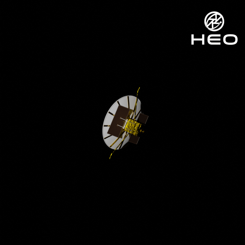
HELSINKI — Australian company HEO has imaged and modeled a mystery Chinese satellite prior to its reentry into Earth’s atmosphere, revealing previously unknown details about the spacecraft.
Xinjishu Yanzheng-7 (XJY-7), a remote sensing technology test satellite developed by the China Academy of Space Technology (CAST), launched on the debut flight of the Long March 8 rocket in December 2020. XJY-7 was officially described as a new technology verification satellite, and the only hint regarding its nature came from a mission control render of the spacecraft after its deployment into orbit.
HEO, which specializes in providing images of spacecraft in orbit using satellites operated by partner Earth observation companies, formally known as non-Earth imaging (NEI), has now provided new insights into the spacecraft, including a synthetic aperture radar (SAR) antenna.
“HEO has characterised and verified key features of the XJY-7 satellite through repeated observations. These include the large radar dish that is now deployed and a SAR antenna,” HEO told SpaceNews.
“To maintain power generation, the spacecraft had to rotate its entire body due to fixed solar arrays. We also completed a few simultaneous imaging missions—where two satellites in our network imaged XJY-7 at the same time—that provided additional behavioural intelligence as we saw almost the entire satellite at a snapshot in time over certain geographies.”
HEO was able to build a verified, high-fidelity 3D model of the spacecraft through multiple 2D observations across different angles and geographies, revealing the satellite’s true configuration and behavior.

“There are many satellites like XJY-7 whose appearance, behaviour, size and purpose remain uncertain. High-frequency imaging is how we’re closing that gap,” HEO said in a statement.
NEI can help satellite operators diagnose issues with spacecraft. But it is also beginning to add a new dimension to conventional Space Domain Awareness (SDA) methods, such as ground radars, telescopes and tracking by adding higher fidelity and richer information. It can reveal shape models, attitude behavior, deployment states and time-tagged operational patterns, which are attributes conventional SDA systems can’t always resolve.
Furthermore, it is also revealing new details about spacecraft which, hitherto, remained mysterious or classified following launch.
There is sometimes also a geopolitical edge to what is also known as satellite-to-satellite imaging. Maxar, now Vantor, in July released imagery of a Chinese experiment Shijian satellite, revealing details of what is thought to be a technology test for China’s new-gen remote sensing. China’s commercial remote sensing commercial Changguang Satellite Technology later used its Jilin-1 Earth observation fleet to return the favor, releasing images of a Worldview satellite.
HEO has carried out around 4,000 imaging operations of spacecraft in low Earth orbit. It is now looking to expand its services to the geostationary belt. Its capabilities have improved in the last couple of years alone, with advances in imaging technologies, techniques, software and, in some cases, self-developed sensors that can be added to partners’ satellites before launch.
“Our approach lets us capture large volumes of data across many objects quickly, like XJY-7, so we have a holistic understanding of many satellites in orbit and how it behaves,” HEO said.
XJY-7 entered a sun-synchronous orbit following launch via Long March 8. It is thought to have reentered Earth’s atmosphere over the Canary Islands Oct. 16 (UTC), according to satellite tracker Marco Langbroek.


Related Posts


Stay Informed With the Latest & Most Important News
Previous Post
Next Post


Advertisement
-
 01Two Black Holes Observed Circling Each Other for the First Time
 -
 02From Polymerization-Enabled Folding and Assembly to Chemical Evolution: Key Processes for Emergence of Functional Polymers in the Origin of Life
 -
 03Astronomy 101: From the Sun and Moon to Wormholes and Warp Drive, Key Theories, Discoveries, and Facts about the Universe (The Adams 101 Series)
 -
 04True Anomaly hires former York Space executive as chief operating officer
 -
 05Φsat-2 begins science phase for AI Earth images
 -
 06Hurricane forecasters are losing 3 key satellites ahead of peak storm season − a meteorologist explains why it matters
 -
 07Binary star systems are complex astronomical objects − a new AI approach could pin down their properties quickly