
Now Reading: Earth from Space: Branco River, Brazil
-
01
Earth from Space: Branco River, Brazil

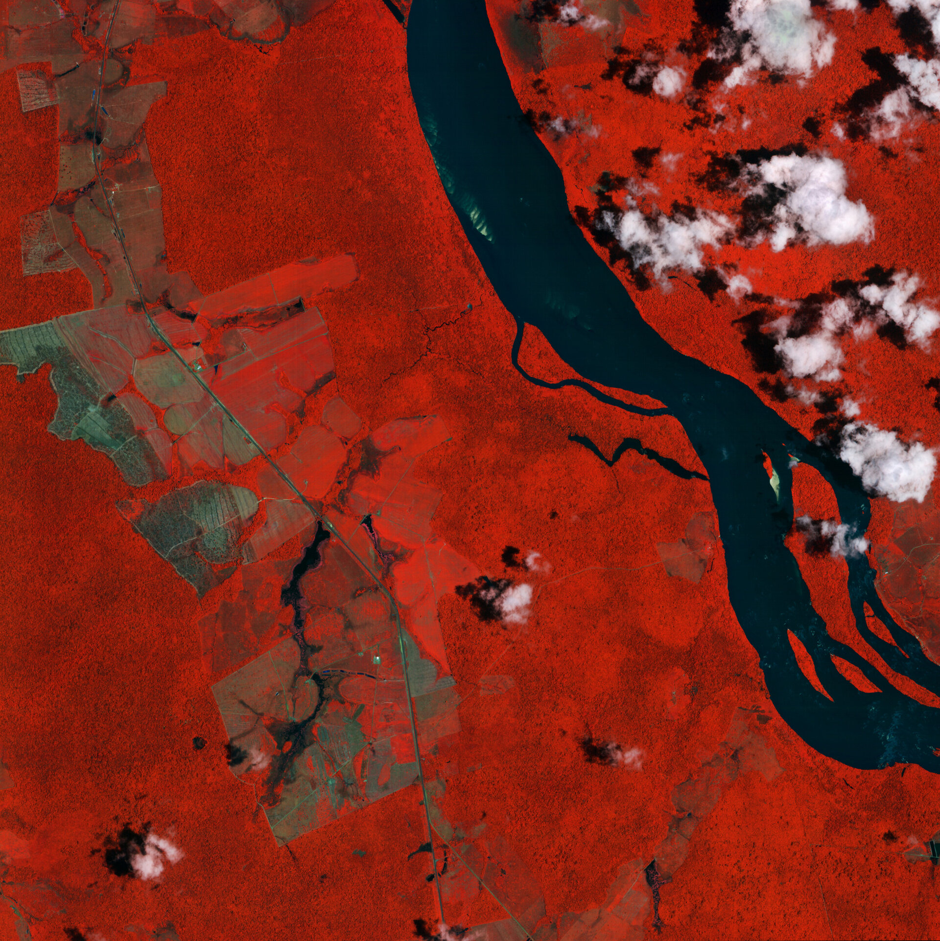

Ahead of the 30th UN Climate Change Conference of the Parties (COP30) taking place in Belém, Brazil, from 10-21 November, this image shows the Branco River and its surrounding forests in the Brazilian state of Roraima. It was captured by IRIDE’s Hawk for Earth Observation (HEO) constellation, launched earlier this year.
The Branco River, or Rio Branco, forms north of the area pictured here, near the city of Boa Vista and flows south-west for 775 km before joining Rio Negro, a major tributary of the Amazon River.
Despite its name which means white river, this false-colour image from 30 September 2025 shows the Rio Branco in black. The HEO constellation’s near-infrared channel, used to process this image, makes water appear in dark blue or black and highlights vegetation in bright red.
This band combination has been used to help us better distinguish between vegetated and non-vegetated areas. Numerous patches in various shades of brown can be clearly seen particularly on the left of the image and indicate where vegetation has been cleared.
Forests and ecosystems worldwide are being destroyed or damaged at an alarming rate. This is of great concern because they play a critical role in global climate and are home to a huge variety of biodiversity. More than a third of all species in the world live in the Amazon rainforest.
Inspiring faster and more ambitious action on climate change from the international community is a central topic of COP30. As in previous years, ESA will participate to highlight the value of space-based observations and to discuss how space data can support commitments made at COP.
With their unique view from space, Earth observation satellites are instrumental in monitoring and protecting ecosystems. Not only does satellite information highlight areas of vulnerability by documenting the scale of loss and damage, but it also supports actionable scientific data to influence and inspire global climate policies.
The HEO constellation, which acquired this image, comprises seven satellites, carrying multispectral optical instruments to provide images at 2.7 m resolution. HEO is the first constellation for the Italian IRIDE Earth observation mission, which is designed to deliver satellite data for a wide range of environmental, emergency and security services.
Coordinated by ESA with support from the Italian Space Agency, the IRIDE programme involves the deployment of six satellite constellations. The second constellation planned is Eaglet II, which is scheduled to be launched in a few days.


Related Posts


Stay Informed With the Latest & Most Important News
Previous Post
Next Post


Advertisement
-
 01Two Black Holes Observed Circling Each Other for the First Time
 -
 02From Polymerization-Enabled Folding and Assembly to Chemical Evolution: Key Processes for Emergence of Functional Polymers in the Origin of Life
 -
 03Astronomy 101: From the Sun and Moon to Wormholes and Warp Drive, Key Theories, Discoveries, and Facts about the Universe (The Adams 101 Series)
 -
 04True Anomaly hires former York Space executive as chief operating officer
 -
 05Φsat-2 begins science phase for AI Earth images
 -
 06Hurricane forecasters are losing 3 key satellites ahead of peak storm season − a meteorologist explains why it matters
 -
 07Binary star systems are complex astronomical objects − a new AI approach could pin down their properties quickly