
Now Reading: The next generation of environmental intelligence: Why high-resolution satellite imagery must power our planet’s future
-
01
The next generation of environmental intelligence: Why high-resolution satellite imagery must power our planet’s future

The next generation of environmental intelligence: Why high-resolution satellite imagery must power our planet’s future
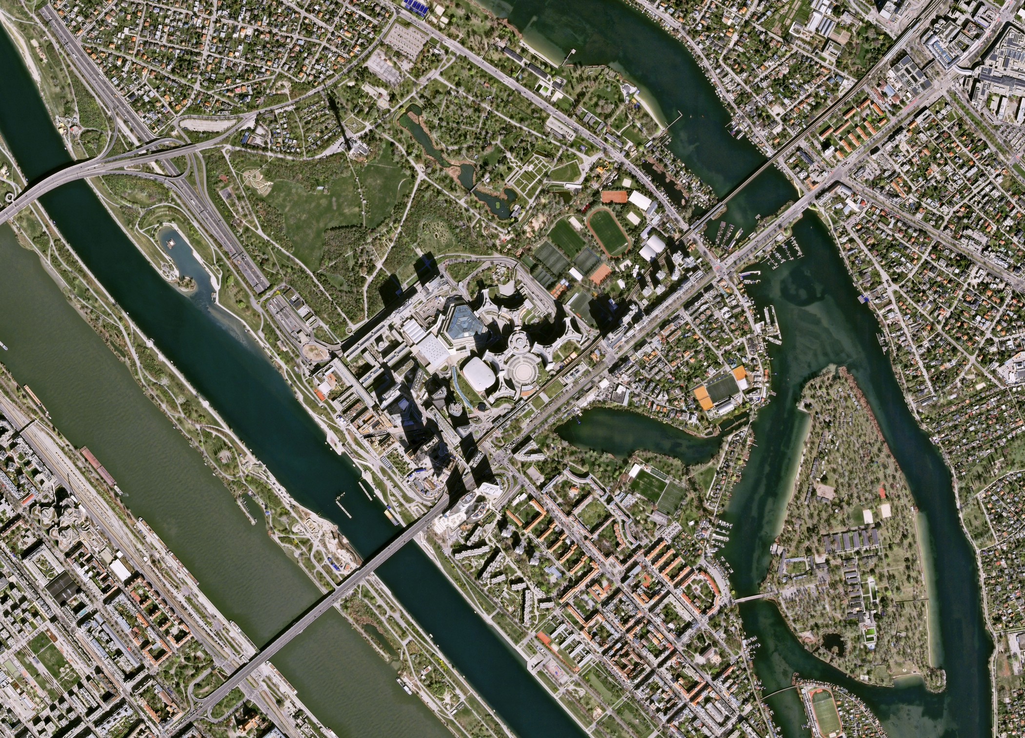

Imagine trying to spot an object just 30 centimeters wide from hundreds of kilometers above Earth. Years ago, I remember when “satellite view” meant blurry green blobs on a screen. Now, we can see individual trees, cars and even shadows cast by buildings. We finally have the power to witness our planet as it truly is: scarred, altering and astonishingly interconnected. It’s a turning point in how we see, understand and ultimately protect our planet.
But as someone who’s followed these technologies closely, I believe the real revolution won’t come from sharper satellite imagery — it will come from what we choose to do with what it reveals. Every pixel now carries a moral weight. If we can see the problem, we can no longer claim ignorance, whether it be deforestation in the Amazon, floods or wildfires in California.
What high-resolution imagery really offers
High-resolution satellites don’t simply take pictures. They record the energy reflected from Earth’s surface across multiple wavelengths, from visible light to infrared, creating images that function more like medical scans of the planet’s body. Scientists can now diagnose ecological “symptoms” — the health of crops, the purity of water or the pace of urban sprawl — using satellite imagery.
But do we really use this “miracle” in full? We’ve built a technology that can literally see environmental destruction almost in real time. High-resolution imagery gives us tools to act precisely to protect ecosystems before they collapse, to farm smartly and reduce waste and to manage disasters immediately. But too often we don’t act fast enough. Bureaucracy, waiting for reports, budgets or “confirmation,” can cost lives and kill the action plan that is on our finger tips.
AI: turning vision into understanding
Yet there’s a paradox. The more clearly satellites see, the more data they generate, to the point that it’s too much for any human team to process. That’s why the next revolution isn’t in the sky, but in the algorithms interpreting it.
Artificial intelligence, especially Convolutional Neural Networks, can now analyze thousands of images to identify subtle, long-term changes invisible to the human eye. AI can tell the difference between trees naturally shedding leaves and a forest being cleared. It can distinguish between seasonal flooding and permanent damage.
These systems achieve over 90% accuracy in identifying deforestation and new urban development, which is fantastic. But it’s not just a technical accomplishment, it’s a fact of how human knowledge and creativity can work with machine learning for the planet.
And I see an irony: We’ve created technology powerful enough to predict ecological collapse, but we still struggle to fund the servers to process the data. Access remains inconsistent. High-resolution data is often closed behind paywalls, while many conservationists and ecological researchers in developing regions, the ones who most need it, can’t afford entry.
If we truly believe in “environmental intelligence,” we have to make it democratic. AI and satellite data must be open, shared and trusted. Otherwise, we risk building a surveillance system for profit, not for the planet.
Building the future of environmental intelligence
If the past decade was about seeing Earth more clearly, the next will be about understanding it more deeply. Ultra-high-resolution imagery, smarter AI and scalable cloud analytics are becoming the three pillars of environmental intelligence.
According to the European Space Agency, more than 1,500 Earth observation satellites will orbit the planet by 2030, many of them small, agile and capable of revisiting the same location multiple times a day.
But here’s my argument: Technology alone won’t save us. It never has. The satellite can take the picture, but only people can make the decision to change. Governments, industries and scientists must work together to make these insights widely accessible, interpretable and ethically used. Otherwise, we’ll have perfect vision of a dying world and no power to intervene.
Seeing our planet clearly and choosing to act
We’ve never been this close to understanding Earth in its full complexity. High-resolution imagery, AI and open data together create what I like to call the conscience of the planet. They show us the truth without filters.
But what will we do with that truth? Will we use it to justify endless reports, or to spark real change? Every flood, every burned forest, every cracked riverbed now has a timestamp and a coordinate. We can’t say “we didn’t know.” We do know. We see it in painfully sharp detail.
And that’s why I believe satellite environmental intelligence must become a shared global mission, not a competition between nations or companies. Because when we look at Earth from space, there are no borders, only consequences.
The satellites are already doing their part. Now it’s our turn to do ours.
Kateryna Sergieieva has a Ph.D. in information technologies and 15 years of experience in remote sensing. She is a scientist responsible for developing technologies for satellite monitoring and surface feature change detection. Kateryna is an author of over 60 scientific publications.
SpaceNews is committed to publishing our community’s diverse perspectives. Whether you’re an academic, executive, engineer or even just a concerned citizen of the cosmos, send your arguments and viewpoints to opinion@spacenews.com to be considered for publication online or in our next magazine. The perspectives shared in these opinion articles are solely those of the authors.


Related Posts
Stay Informed With the Latest & Most Important News
Previous Post
Next Post


Advertisement
-
 01Two Black Holes Observed Circling Each Other for the First Time
 -
 02From Polymerization-Enabled Folding and Assembly to Chemical Evolution: Key Processes for Emergence of Functional Polymers in the Origin of Life
 -
 03Astronomy 101: From the Sun and Moon to Wormholes and Warp Drive, Key Theories, Discoveries, and Facts about the Universe (The Adams 101 Series)
 -
 04True Anomaly hires former York Space executive as chief operating officer
 -
 05Φsat-2 begins science phase for AI Earth images
 -
 06Hurricane forecasters are losing 3 key satellites ahead of peak storm season − a meteorologist explains why it matters
 -
 07Binary star systems are complex astronomical objects − a new AI approach could pin down their properties quickly