
Now Reading: Sentinel-6B Satellite Launched to Monitor Ocean Conditions and Support Climate Research
-
01
Sentinel-6B Satellite Launched to Monitor Ocean Conditions and Support Climate Research

Sentinel-6B Satellite Launched to Monitor Ocean Conditions and Support Climate Research
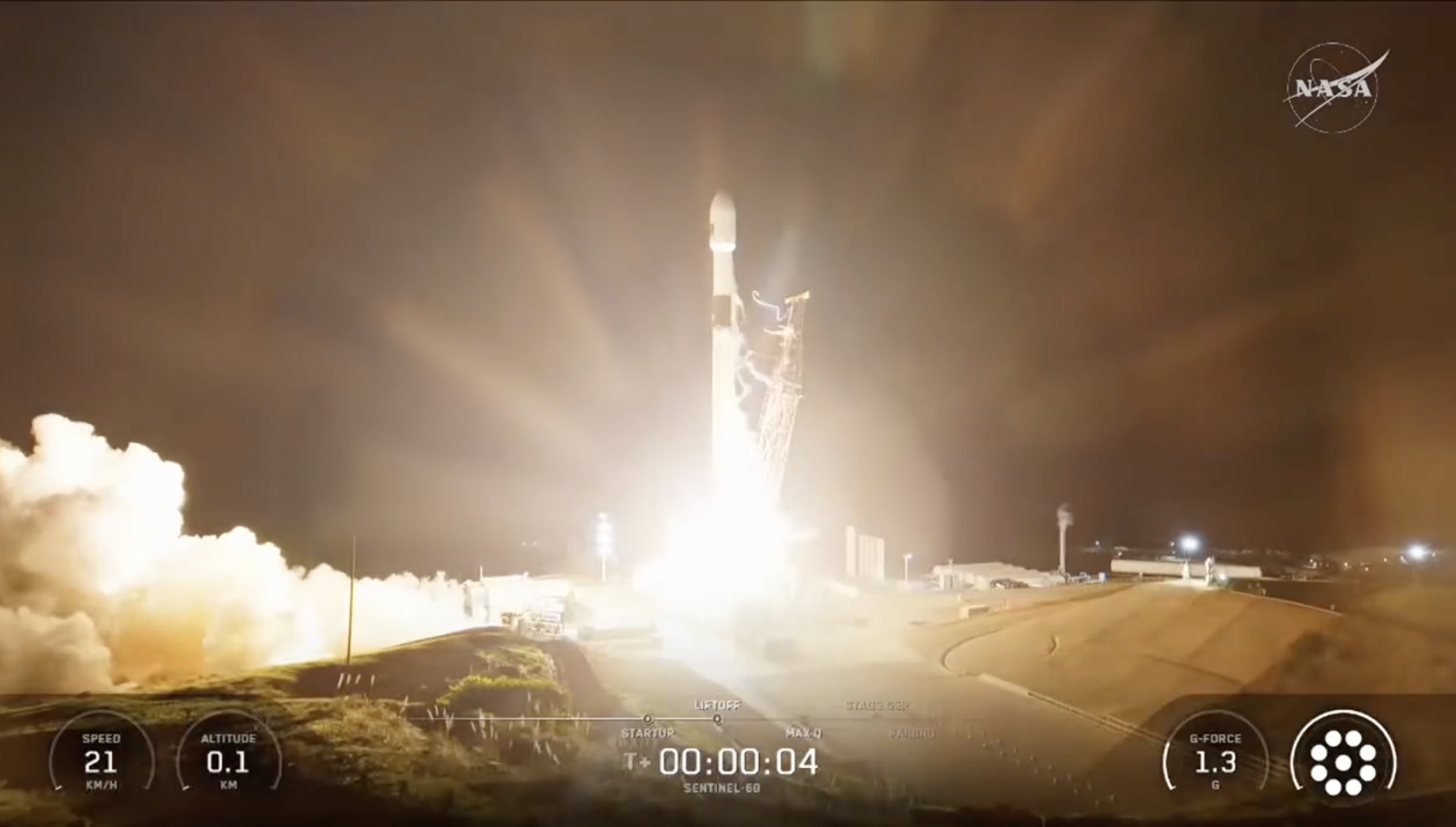

The Sentinel-6B, a collaborative satellite designed to monitor ocean conditions, successfully launched on Sunday aboard a SpaceX Falcon 9 rocket. The mission took off from Vandenberg Space Force Base in California at 9:21 p.m. Pacific Time, marking a significant milestone in international efforts to track environmental changes.
This satellite is the second in the Jason Continuity of Service (Jason-CS) program, following its sibling Sentinel-6A, which was launched five years earlier. The Sentinel-6 missions are the latest iteration in a lineage of ocean topography satellites that began with the TOPEX/Poseidon mission in 1992. Over the decades, the series transitioned through three Jason satellites before aligning with the European Copernicus program, adopting the Sentinel moniker.
The Sentinel-6B mission is a partnership between space and environmental agencies across the United States and Europe. The European Organisation for the Exploitation of Meteorological Satellites (EUMETSAT) oversees operation of the satellite in collaboration with the U.S. National Oceanic and Atmospheric Administration (NOAA). Other partners include NASA, the European Space Agency (ESA), and the European Union’s space program. As part of the Copernicus initiative, Sentinel-6B is tasked with providing critical data on global sea levels, wave heights, and ocean wind patterns.
With its launch, Sentinel-6B ensures continuity of over 30 years of data collected by previous satellites in this series. It is designed to operate alongside Sentinel-6A for a year before fully taking over its role as the reference point for other altimetry satellites, which will rely on its measurements for calibration.
Equipped with an advanced suite of instruments similar to those on Sentinel-6A, the centerpiece of Sentinel-6B is the Poseidon-4 radar altimeter. This complex device utilizes a 1.2-meter parabolic reflector to send radio waves towards the ocean’s surface, accurately measuring the time it takes for the signals to bounce back. This data enables precise calculations of the ocean surface’s height.
Poseidon-4 incorporates both traditional pulse-width and synthetic aperture radar techniques while operating on two frequency bands to improve measurement accuracy and mitigate ionospheric interference. Complementing these capabilities, the Advanced Microwave Radiometer for Climate (AMR-C) monitors water vapor that could impact the radar’s readings, with its own dual radiometer setup operating across multiple frequencies.
For precise position tracking, Sentinel-6B includes the Precise Orbit Determination (POD) package. This suite uses a Doppler method along with signals from a network of beacons worldwide to refine its orbital measurements. Additionally, it features Global Navigation Satellite System (GNSS) capabilities for enhanced tracking and atmospheric analysis, allowing scientists to obtain atmospheric profiles critical for understanding environmental conditions.
Weighing in at 1,190 kilograms and measuring nearly 6 meters when fully deployed, Sentinel-6B orbits at an altitude of 1,336 kilometers, covering about 95% of the Earth’s non-icy oceans every ten days.
SpaceX’s Falcon 9 rocket, which has achieved over 560 launches since its debut in 2010, was the vehicle for this mission. The particular booster used, B1097.3, accomplished its third flight during this launch, safely returning to Vandenberg for a successful landing shortly after deployment of the satellite.
The satellite, built by Airbus Defence and Space in Germany, was carefully stored after its construction and testing in 2022 until it was transported to the launch site in California in mid-August for final preparations. As the Falcon 9 ignited its engines and took to the skies, it followed a southeasterly trajectory over the Pacific, passing through various crucial stages before successfully deploying Sentinel-6B into orbit approximately 56 minutes after launch.
With the deployment of Sentinel-6B, the scientific community anticipates a new era of invaluable oceanic data that will aid in understanding climate change and enhancing weather forecasts.


Related Posts

Stay Informed With the Latest & Most Important News
Previous Post
Next Post


Advertisement
-
 01Two Black Holes Observed Circling Each Other for the First Time
 -
 02From Polymerization-Enabled Folding and Assembly to Chemical Evolution: Key Processes for Emergence of Functional Polymers in the Origin of Life
 -
 03Astronomy 101: From the Sun and Moon to Wormholes and Warp Drive, Key Theories, Discoveries, and Facts about the Universe (The Adams 101 Series)
 -
 04True Anomaly hires former York Space executive as chief operating officer
 -
 05Φsat-2 begins science phase for AI Earth images
 -
 06Hurricane forecasters are losing 3 key satellites ahead of peak storm season − a meteorologist explains why it matters
 -
 07Binary star systems are complex astronomical objects − a new AI approach could pin down their properties quickly