
Now Reading: Pacific Geomatics and SI Analytics Announce Strategic Partnership to Deliver Super-Resolution Capabilities Across Canada
-
01
Pacific Geomatics and SI Analytics Announce Strategic Partnership to Deliver Super-Resolution Capabilities Across Canada

Pacific Geomatics and SI Analytics Announce Strategic Partnership to Deliver Super-Resolution Capabilities Across Canada
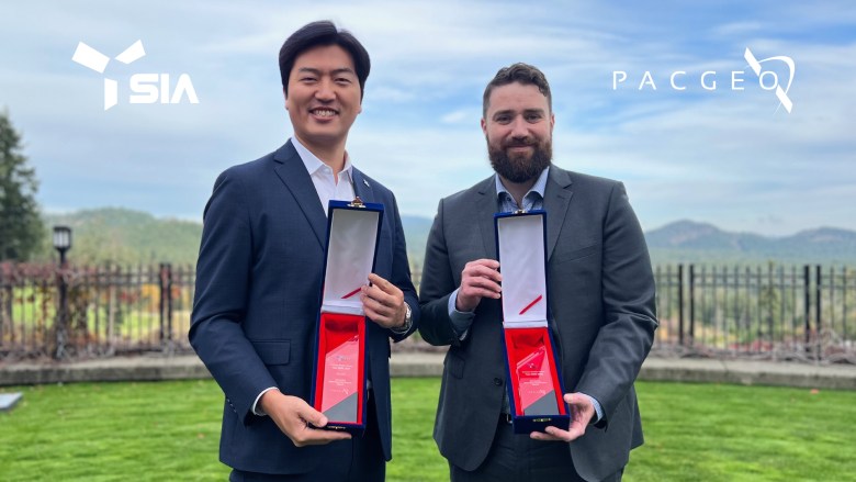
Victoria, Canada / Seoul, South Korea – November 27th, 2025 – Pacific Geomatics Limited (PacGeo), a Canadian satellite imagery distributor, today announced a strategic partnership with SI Analytics (SIA), a leader in AI-driven Earth observation solutions, to expand the global reach of SuperX, a Generative AI-based satellite imagery super-resolution solution built on multi-resolution Foundation Models.

The collaboration brings together SIA’s state-of-the-art generative AI technology and PacGeo’s regional distribution and customer network to provide unparalleled imagery enhancement that enables advanced geospatial analysis and image interpretation for governments, defence agencies, and commercial organizations in Canada.
“SuperX represents a paradigm shift in satellite analytics,” said Taegyun Jeon, CEO of SI Analytics. “By integrating generative AI with foundation models trained across multiple resolutions, we’re enabling machines not only to analyze imagery — but to understand, reconstruct, and predict what’s on Earth.”
“Through this partnership, PacGeo has Canadian exclusivity to one of the most advanced AI-powered super-resolution tools for fresh and archive satellite imagery,” said Matt Tomlins, President of Pacific Geomatics. “Together with SIA, we aim to make high-resolution satellite imagery more accessible and cost-effective for users across industries.”
About SuperX
SuperX is a Generative AI-powered satellite image super-resolution technology designed to enhance satellite imagery by doubling the resolution. Built upon SIA’s proprietary Foundation Models, SuperX can process and learn from multi-resolution satellite data — from 0.25m ultra-high-resolution imagery to low-resolution global datasets.
Its architecture enables:
• Previously unheard-of clarity with vibrant colours and crisp details
• Analysis-ready imagery for advanced GEOINT data analysis
• Prerequisite processing for context-aware analytics solutions, including object detection, change monitoring, and area segmentation
SuperX is designed to scale across both commercial and defence domains, bringing next-level imagery capabilities to operational geospatial workflows.
About SI Analytics
SI Analytics is a Korea-based geospatial AI company specializing in satellite data analytics, Earth observation, and defence intelligence solutions. Leveraging deep learning and space technology, SIA develops advanced platforms that transform large-scale satellite imagery into actionable insights for governments, enterprises, and research institutions.
About PacGeo
Pacific Geomatics (PacGeo) is a Canadian company with 30+ years of industry experience providing satellite imagery, data distribution, and geospatial solutions to clients across North America, and around the world. With expertise in imagery access, analytics integration, and Earth observation systems, PacGeo connects customers with advanced geospatial data and tools tailored to understand and inform their critical decisions.
For access to SI Analytics SuperX in Canada, please contact:
Pacific Geomatics Limited
https://pacgeo.com/consult-our-experts/
Learn more:
Website: https://pacgeo.com/
LinkedIn: https://www.linkedin.com/company/pacgeo/
Mailing list: https://pacgeo.com/join-mailing-list


Related Posts

Stay Informed With the Latest & Most Important News
Previous Post
Next Post
Previous Post
Next Post


Advertisement
-
 01Two Black Holes Observed Circling Each Other for the First Time
 -
 02From Polymerization-Enabled Folding and Assembly to Chemical Evolution: Key Processes for Emergence of Functional Polymers in the Origin of Life
 -
 03Astronomy 101: From the Sun and Moon to Wormholes and Warp Drive, Key Theories, Discoveries, and Facts about the Universe (The Adams 101 Series)
 -
 04True Anomaly hires former York Space executive as chief operating officer
 -
 05Φsat-2 begins science phase for AI Earth images
 -
 06Hurricane forecasters are losing 3 key satellites ahead of peak storm season − a meteorologist explains why it matters
 -
 07Binary star systems are complex astronomical objects − a new AI approach could pin down their properties quickly