
Now Reading: Earth from Space: Pariacaca Mountain Range, Peru
-
01
Earth from Space: Pariacaca Mountain Range, Peru

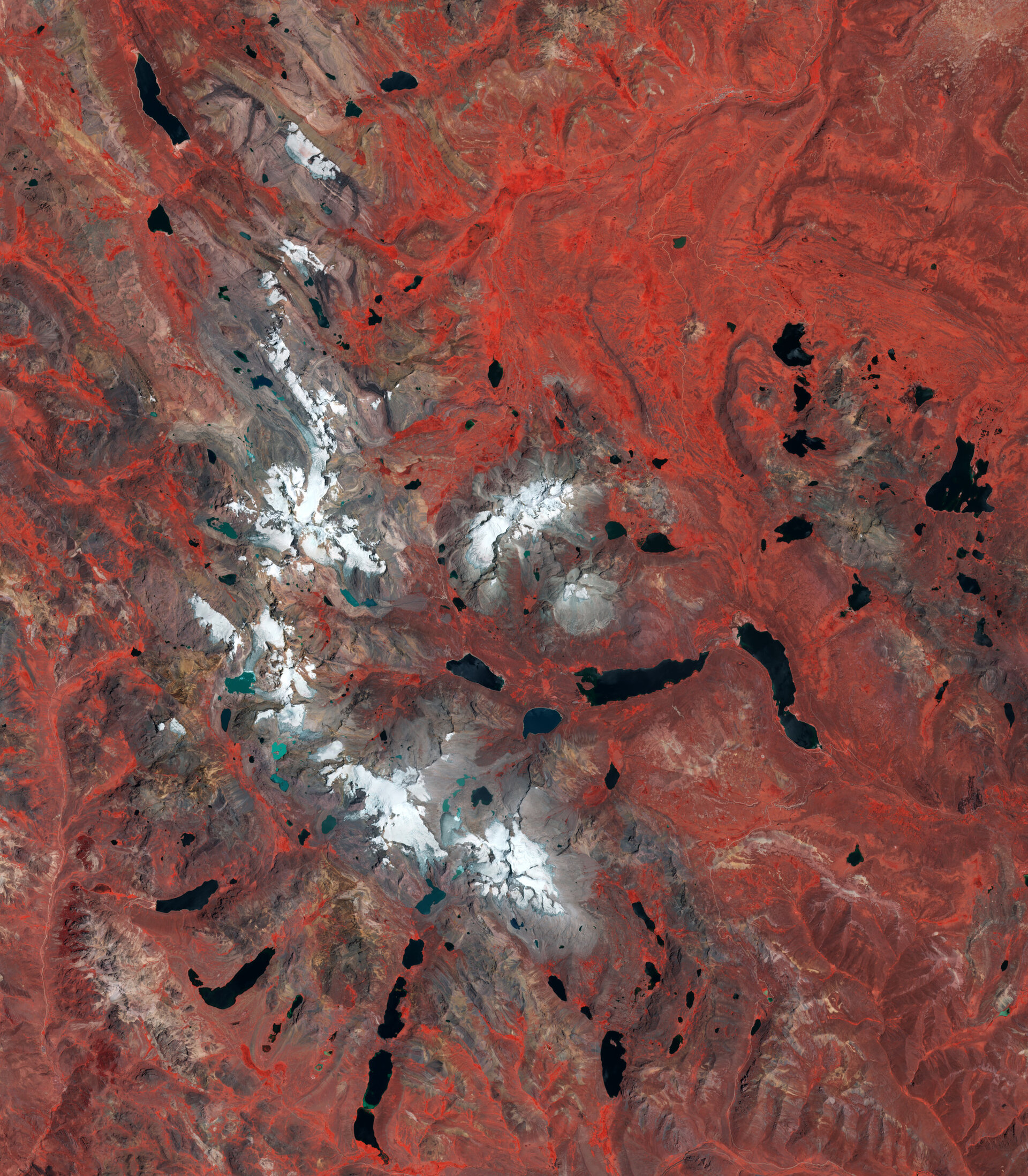

Following International Mountain Day, which creates awareness of the importance of mountain environments around the world, the Copernicus Sentinel-2 mission takes us over the Pariacaca Mountain Range in Peru.
Zoom in or click on the circles to explore this image at its full resolution.
Also called the Huarochirí mountain range, the Pariacaca range is a significant part of the Peruvian central Andes, the Cordillera Central. Pariacaca is known for its beautiful and rugged peaks, many of them reaching over 5000 m in height.
This false-colour image from 7 December has been processed using Sentinel-2’s near-infrared channel to highlight vegetation in red. Due to the location, the arid climate and the altitude, the vegetation mainly consists of shrubs and grassland, with patches of forest seen in darker red and valleys with lusher vegetation visible in brighter red.
Many peaks appear covered in a blanket of snow, including the highest in the mountain range sharing the same name, Pariacaca, which stands more than 5700 m above sea level. This impressive mountain, which is the white peak at the bottom of the image, sits in between the Junín and Lima regions of Peru.
Numerous lakes, most of which are of glacial origin, are visible in the image both in black and in shades of green. The younger glacial lakes lie higher in altitude and are closer to the glacial fields. Their emerald hues are caused by the concentration of very tiny rock particles suspended in the water.
Many glaciers are also pictured in the image. The Nevado Pariacaca glacial system is very important in terms of hydrological impact in the area. Although not very large, the glaciers act as ‘water towers’, storing water during the wet season and releasing it slowly during the dry season. This seasonal cycle regulates the flow of rivers, which are vital for the water supply in both Lima and Junín.
The rapid retreat of glaciers in the area is a major hydrological challenge for Peru. It is estimated that around 50% of the glaciers’ surface area has been lost since 1970. This significant retreat can also be appreciated in the image, as the lower part of the mountains, where the glaciers used to be, appear grey due to lack of vegetation.
In addition to their critical role in regulating water resources, glaciers also have a direct influence on natural hazards such as glacial lake outburst floods and ice avalanches, which have resulted in substantial casualties and damage to infrastructure in recent decades.
Although considerable effort has been put into quantifying and understanding glacier shrinking and thawing, there are regions where a comprehensive assessment is still missing or limited due to the challenging conditions. This is where Earth observing missions such as Copernicus Sentinel-2 can greatly contribute to mapping and monitoring the changing face of glaciers in such remote and unique environments.


Related Posts

Stay Informed With the Latest & Most Important News
Previous Post
Next Post


Advertisement
-
 01Two Black Holes Observed Circling Each Other for the First Time
 -
 02From Polymerization-Enabled Folding and Assembly to Chemical Evolution: Key Processes for Emergence of Functional Polymers in the Origin of Life
 -
 03Astronomy 101: From the Sun and Moon to Wormholes and Warp Drive, Key Theories, Discoveries, and Facts about the Universe (The Adams 101 Series)
 -
 04True Anomaly hires former York Space executive as chief operating officer
 -
 05Φsat-2 begins science phase for AI Earth images
 -
 06Hurricane forecasters are losing 3 key satellites ahead of peak storm season − a meteorologist explains why it matters
 -
 07Binary star systems are complex astronomical objects − a new AI approach could pin down their properties quickly