
Now Reading: Sentinel-6B Satellite Launches to enhance Climate Monitoring with New Sea Level Data
-
01
Sentinel-6B Satellite Launches to enhance Climate Monitoring with New Sea Level Data

Sentinel-6B Satellite Launches to enhance Climate Monitoring with New Sea Level Data
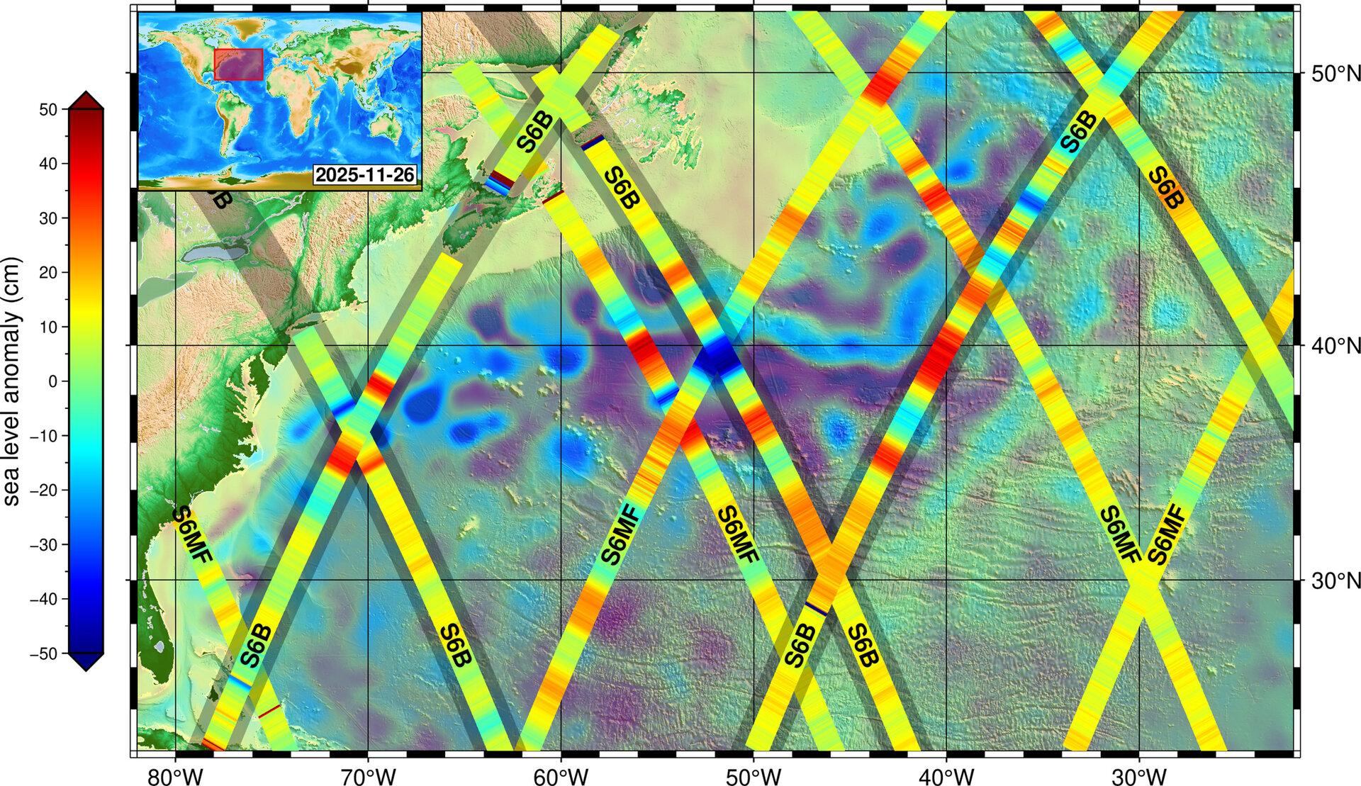

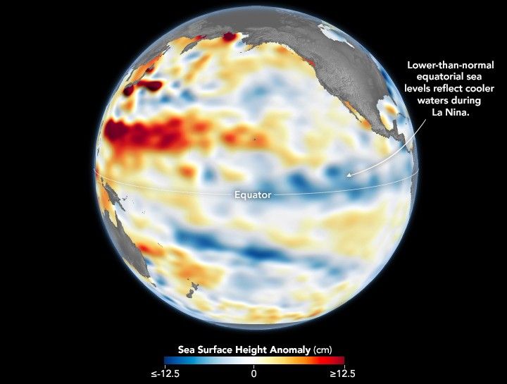
The Copernicus Sentinel-6B satellite, which was launched on November 17, 2025, has successfully attained its operational orbit and is already sending back significant data regarding sea level variations in the North Atlantic. This latest information especially important as it will enhance the long-term record of sea levels, a vital indicator of climate change.
The inaugural data capture from Sentinel-6B took place on November 26, using its advanced Poseidon-4 altimeter. The data collected produced a detailed image amalgamating measurements from both Sentinel-6 satellites: Sentinel-6B and its predecessor, Sentinel-6 Michael Freilich, launched in 2020. This combined data prominently features the Gulf Stream current, a critical region in the North Atlantic, known for its influence on global climate patterns, importance as a shipping route, and significant marine ecosystems that support various fishing industries. Pierrik Vuilleumier, ESA’s Project Manager for Sentinel-6, commended the teams involved for ensuring the continuity of mean sea-level records, which now extends an impressive five years beyond the previous 35 years of collected data.
The innovative Poseidon-4 altimeter employed by Sentinel-6B utilizes dual-frequency radar technology, enhancing resolution and performance compared to earlier models. By measuring the time taken for radar pulses to return from the Earth’s surface, the altimeter allows for precise calculations of sea-surface height, wave height, and wind speeds. Additionally, the satellite is equipped with a microwave radiometer that accounts for atmospheric delays, further refining measurement accuracy.
Sentinel-6B is not just pivotal for tracking sea-level changes; it also contributes to operational ocean forecasting, delivering near real-time data essential for navigation safety, improved coastal defenses, and efficient water management. Simonetta Cheli, ESA’s Director of Earth Observation Programmes, emphasized the agency’s commitment to developing missions that can reliably monitor sea-level rise and provide essential data to the scientific community and policymakers. She acknowledged the collaborative efforts of European partners alongside NASA and NOAA in cultivating the groundbreaking technologies that make this satellite’s data invaluable.
The early performance of Sentinel-6B has been promising, according to Alejandro Egido, ESA’s Mission Scientist for Sentinel-6. While further calibration is planned in the months ahead, the initial dataset quality indicates a robust foundation for extending sea-surface height measurements through at least 2030.
The Copernicus Sentinel-6 mission stands as a reference for satellite altimetry, crucial for monitoring the ongoing rise in sea levels—a pressing issue on the global climate agenda. Through meticulous international collaboration involving the European Commission, ESA, NASA, Eumetsat, and NOAA, Sentinel-6 aims to set a gold standard in delivering precise sea-surface height measurements, solidifying its role as an essential source of data for understanding and addressing climate change impacts.


Related Posts
Stay Informed With the Latest & Most Important News
Previous Post
Next Post

Advertisement
-
 01Two Black Holes Observed Circling Each Other for the First Time
 -
 02From Polymerization-Enabled Folding and Assembly to Chemical Evolution: Key Processes for Emergence of Functional Polymers in the Origin of Life
 -
 03Astronomy 101: From the Sun and Moon to Wormholes and Warp Drive, Key Theories, Discoveries, and Facts about the Universe (The Adams 101 Series)
 -
 04True Anomaly hires former York Space executive as chief operating officer
 -
 05Φsat-2 begins science phase for AI Earth images
 -
 06Hurricane forecasters are losing 3 key satellites ahead of peak storm season − a meteorologist explains why it matters
 -
 07Binary star systems are complex astronomical objects − a new AI approach could pin down their properties quickly