
Now Reading: Smoke plumes from Chile wildfires seen by Sentinel-3
-
01
Smoke plumes from Chile wildfires seen by Sentinel-3

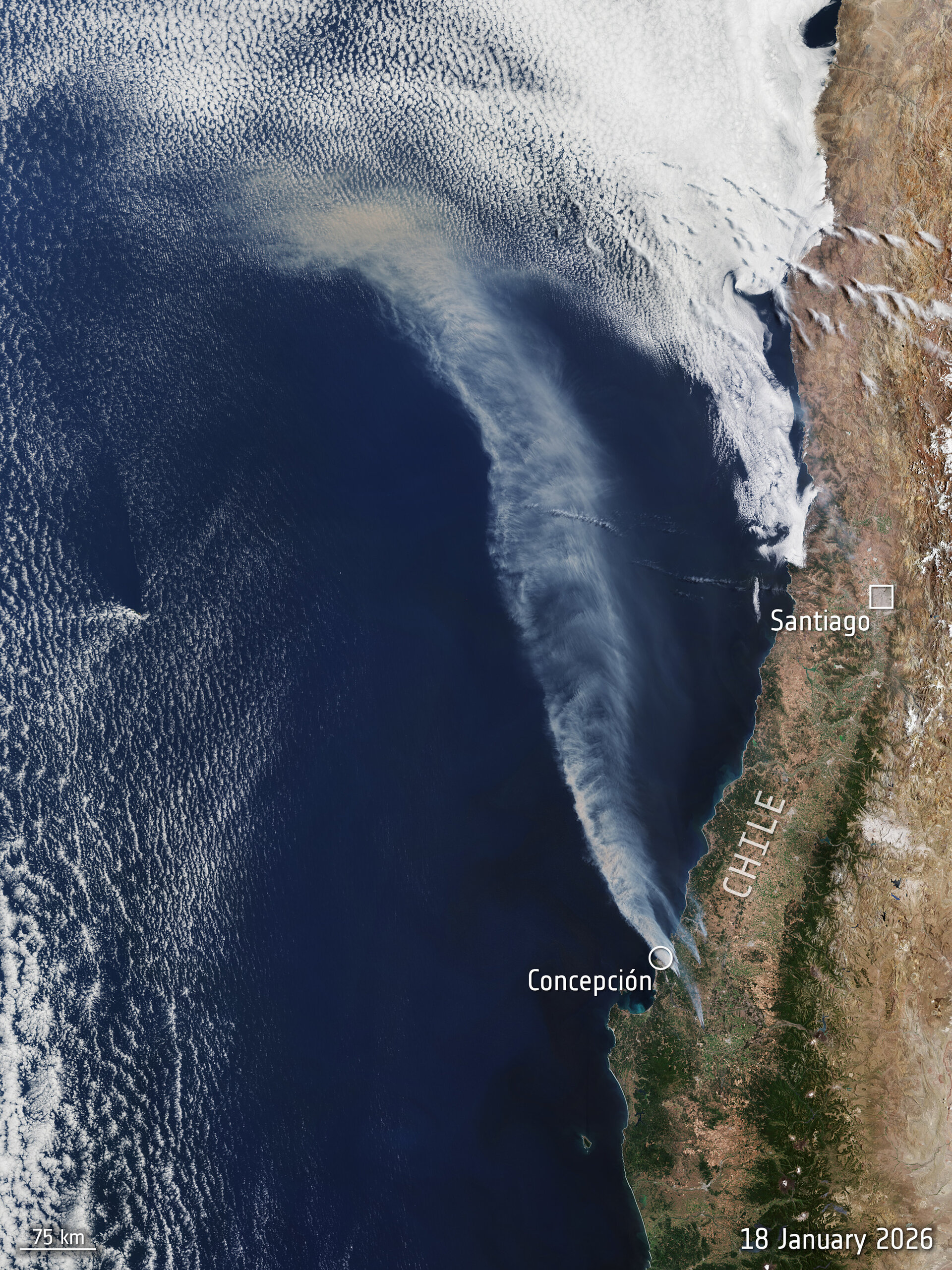

This image, captured by Copernicus Sentinel-3 on 18 January 2026, shows clouds of smoke from wildfires on the coast of Chile.
The fires have been burning in numerous locations along Chile’s coast, including in the regions of Ñuble and Biobío, where a state of catastrophe has been declared.
This image shows one of the most badly affected areas, near the city of Concepcion, approximately 570 km southwest of the capital Santiago. The fires have been exacerbated by intense heat in the region and high winds, with parts of central and southern Chile forecast to reach temperatures up to 35 degrees Celcius on Tuesday. Hundreds of homes have been destroyed in the fire and at least 19 casualties have been reported.
The image was captured by Sentinel-3’s Ocean and Land Colour Instrument (OLCI), an imaging spectrometer. OLCI’s 21 distinct spectral bands measure data on ocean colour and vegetation with a spatial resolution of 300 m. This provides data for monitoring ocean ecosystems, supporting crop management and agriculture and providing estimates of atmospheric aerosol and clouds.
The Copernicus Sentinel-3 mission consists of two satellites, with a third satellite due to be launched later this year.


Related Posts


Stay Informed With the Latest & Most Important News
Previous Post
Next Post

Advertisement
-
 01Two Black Holes Observed Circling Each Other for the First Time
 -
 02From Polymerization-Enabled Folding and Assembly to Chemical Evolution: Key Processes for Emergence of Functional Polymers in the Origin of Life
 -
 03Astronomy 101: From the Sun and Moon to Wormholes and Warp Drive, Key Theories, Discoveries, and Facts about the Universe (The Adams 101 Series)
 -
 04True Anomaly hires former York Space executive as chief operating officer
 -
 05Φsat-2 begins science phase for AI Earth images
 -
 06Hurricane forecasters are losing 3 key satellites ahead of peak storm season − a meteorologist explains why it matters
 -
 07Binary star systems are complex astronomical objects − a new AI approach could pin down their properties quickly