
Now Reading: Earth from Space: Pantanal
-
01
Earth from Space: Pantanal

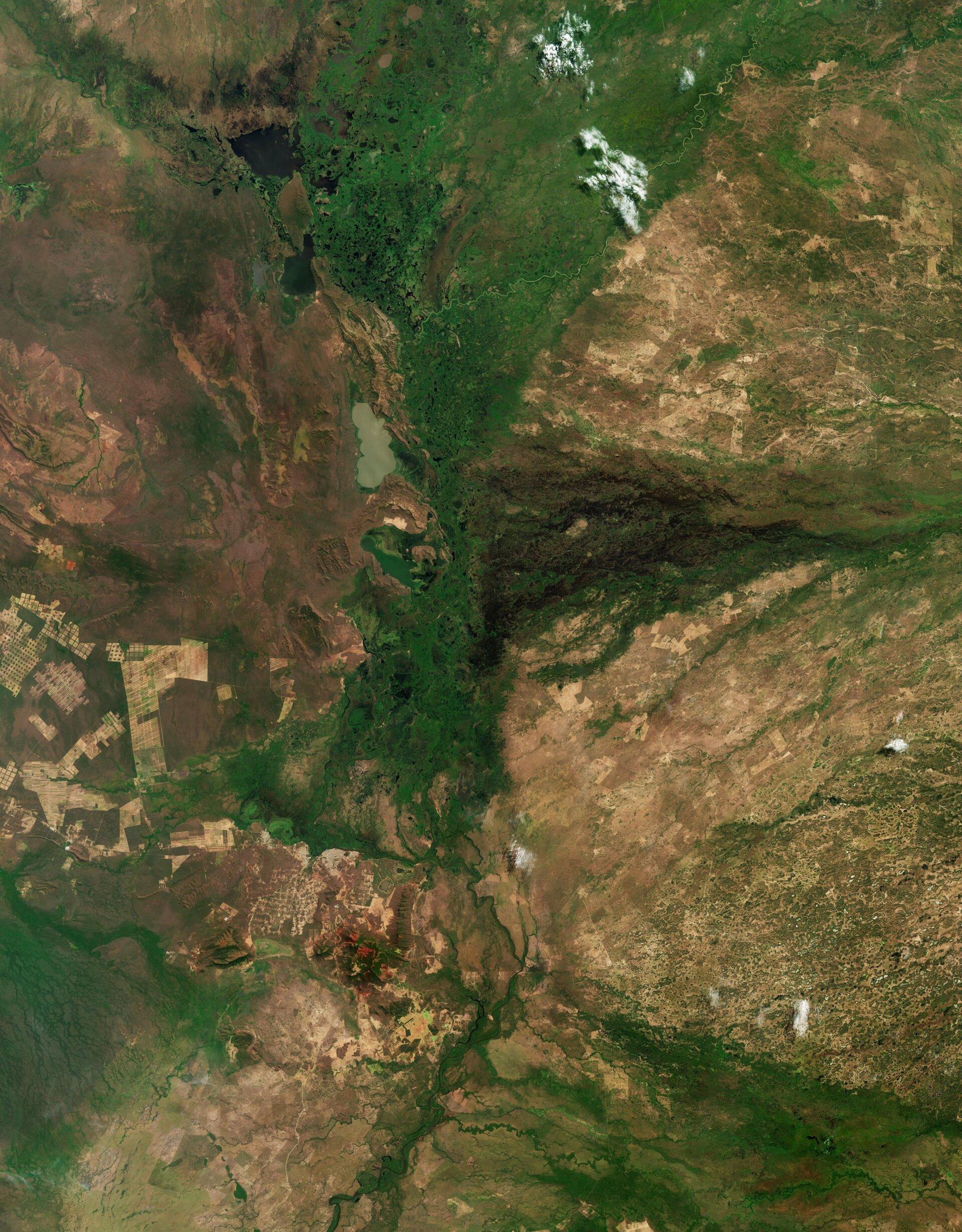

The Copernicus Sentinel-2 mission takes us at the Brazilian-Bolivian border over part of the Pantanal region, a unique ecosystem, home to an impressive variety of plants and wildlife.
Zoom in or click on the circles to explore this image at its full resolution.
Covering an area of up to 200 000 sq km, the Pantanal is the largest floodplain in the world and a wetland of international importance. It is mainly located within the Brazilian states of Mato Grosso and Mato Grosso do Sul, but it also extends into Bolivia and Paraguay.
This image from September 2025 captures a small fraction of the Pantanal, which straddles the border between Bolivia to the west, and the Brazilian states of Mato Grosso to the north and Mato Grosso do Sul to the east. A complex mosaic of flooded grasslands, savannas, tropical forests, rivers and human settlements are visible in the image.
The dark green corridor slicing vertically through the centre is dense, ‘riparian’ vegetation – which is found along the floodplain channels and permanent wetlands. In contrast, the surrounding savannas are visible in brown.
The Pantanal acts as an enormous internal delta, where several rivers merge, feeding the vast network of wetlands. The Rio Paraguay, seen meandering across the green lush band, is the most important river in Pantanal as its natural flood cycle creates the region’s unique environment and supports its diverse fauna.
Following the riverbed southwards, we can see some urban structures. The largest to the west is the Brazilian city of Corumbá, which serves as a gateway to Pantanal. Its rectangular grid is surrounded to the south by a patchwork of fields and brownish pastures.
The reddish-brown areas are expanses of cracked clay soil, which are exposed during the dry season. These areas, barren in September when this image was acquired, become green during the wet season from November to April.
The two conurbations visible west of Corumbá are the inland ports of Puerto Suarez and Puerto Quijarro, on the Bolivian side of the border. The light brown patches on the left represent savanna and forest cleared for cattle pastures and ranches. The thin strips of land are most likely cultivated soybean fields.
This region has undergone significant deforestation in recent years, with some areas transformed from dense forest into a mosaic of fields.


Related Posts

Stay Informed With the Latest & Most Important News
Previous Post
Next Post
Previous Post
Next Post


Advertisement
-
 01Two Black Holes Observed Circling Each Other for the First Time
 -
 02From Polymerization-Enabled Folding and Assembly to Chemical Evolution: Key Processes for Emergence of Functional Polymers in the Origin of Life
 -
 03Astronomy 101: From the Sun and Moon to Wormholes and Warp Drive, Key Theories, Discoveries, and Facts about the Universe (The Adams 101 Series)
 -
 04True Anomaly hires former York Space executive as chief operating officer
 -
 05Φsat-2 begins science phase for AI Earth images
 -
 06Hurricane forecasters are losing 3 key satellites ahead of peak storm season − a meteorologist explains why it matters
 -
 07Binary star systems are complex astronomical objects − a new AI approach could pin down their properties quickly