
Now Reading: Earth from Space: Giza, Egypt
-
01
Earth from Space: Giza, Egypt

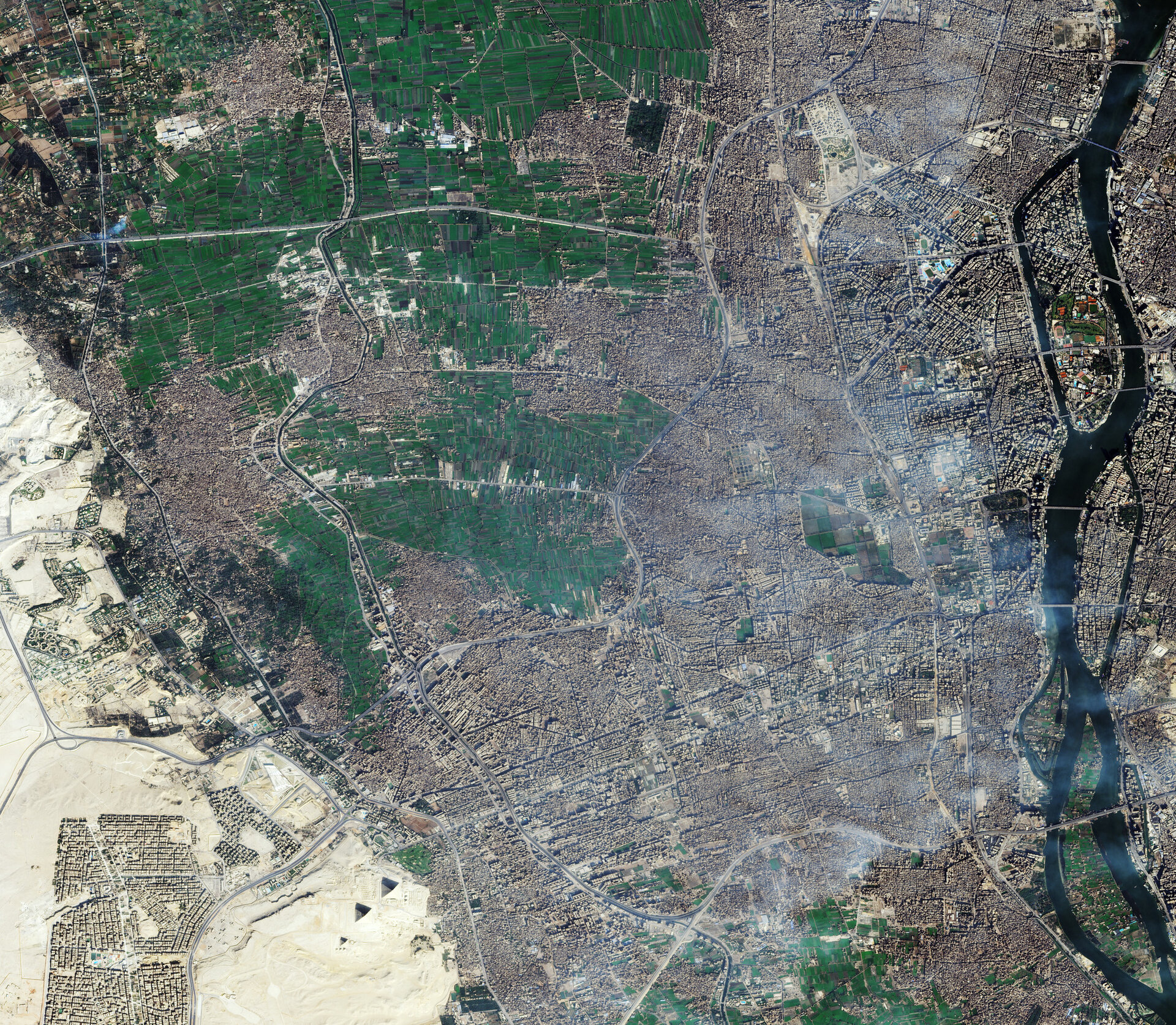

This very high-resolution image captures the Egyptian city of Giza and its surrounding area, including the world-famous Giza Pyramid Complex.
Zoom in to explore this image at its full resolution or click on the circles to learn more.
The third largest city in Egypt by area, Giza is on the west bank of the Nile River, which flows north on the right of the image, separating Giza on the west from the capital Cairo to the east. A number of bridges can be seen connecting the two cities.
Known as the father of African rivers, the Nile is the longest river in the world. The fertile land near its banks has always allowed the Egyptians to grow produce and thrive in the arid desert.
In this image, the green agricultural fields stand out against the grey of Giza’s dense conurbation. To the southwestern edge of the city, yellow and ochre denote the dry sand of the desert and the Giza Plateau, hosting some of the most impressive ancient monuments in the world.
The distinctive shape of the Great Pyramids of Giza can be observed in the lower part of the image, half lit by the Sun and casting distinctive shadows. The northernmost and largest pyramid seen here is that of Khufu, or Cheops, and is also the oldest of the three, built in around 2600 BC. The middle pyramid was built for the pharaoh Khafre and the southernmost and smallest of the three monuments is that of Menkaure, built in around 2510 BC.
Zooming in, smaller pyramids can be seen adjacent to the Cheops and the Menkaure pyramids. These were burial sites for other members of the royal family. The square structures of mortuary temples are also visible near each pyramid. East of the Khafre pyramid, the Great Sphinx can be recognised, one of Egypt’s most famous landmarks.
About 2 km northwest of the pyramids lies the Grand Egyptian Museum, visible as a white, rhomboid structure surrounded by large plazas filled with date palms. Occupying a 50-hectare plot of land, the museum is the largest archaeological museum in the world.
This image was acquired by the Vision-1 mission, which provides images with a resolution of up to 0.87 m. Vision-1 is part of ESA’s Third Party Missions programme, which means ESA uses its multi-mission ground systems and expertise to acquire, process, distribute and archive data from a wide range of satellite missions developed and operated by other agencies.


Related Posts


Stay Informed With the Latest & Most Important News
Previous Post
Next Post


Advertisement
-
 01Two Black Holes Observed Circling Each Other for the First Time
 -
 02From Polymerization-Enabled Folding and Assembly to Chemical Evolution: Key Processes for Emergence of Functional Polymers in the Origin of Life
 -
 03Astronomy 101: From the Sun and Moon to Wormholes and Warp Drive, Key Theories, Discoveries, and Facts about the Universe (The Adams 101 Series)
 -
 04True Anomaly hires former York Space executive as chief operating officer
 -
 05Φsat-2 begins science phase for AI Earth images
 -
 06Hurricane forecasters are losing 3 key satellites ahead of peak storm season − a meteorologist explains why it matters
 -
 07Binary star systems are complex astronomical objects − a new AI approach could pin down their properties quickly