
Now Reading: FireSat adds orbit-visualization software to help firefighters plan around satellite passes
-
01
FireSat adds orbit-visualization software to help firefighters plan around satellite passes

FireSat adds orbit-visualization software to help firefighters plan around satellite passes
WASHINGTON — Developers of wildfire-detection satellites are moving beyond raw data delivery, adding tools that show firefighters and researchers when satellites will actually pass over the areas they are watching.
The nonprofit Earth Fire Alliance, which is funding the FireSat constellation, last month awarded a contract of undisclosed value to ExoAnalytic Solutions to build software that visualizes satellite orbits and sensor coverage. The goal is to help fire response managers and scientists understand when space-based sensors will collect data over specific regions, and how that timing should shape operational decisions.
“Visualization tools that make data accessible and actionable to any organization, regardless of their scale, geography or resources” are critical to making fire-detection satellites usable, the Earth Fire Alliance said.
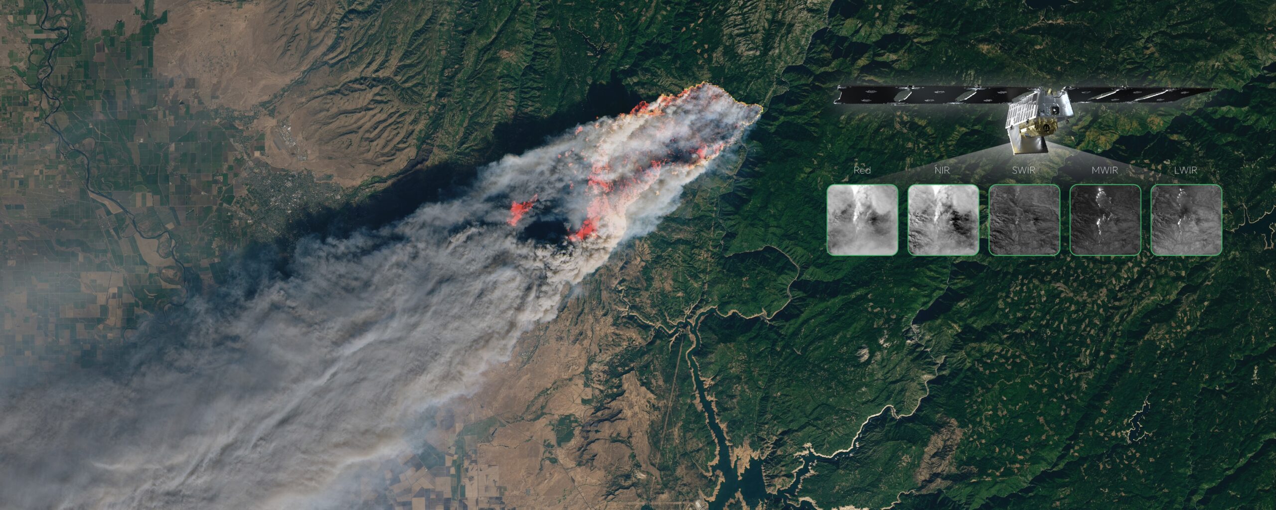
FireSat is designed to detect, monitor and characterize wildfires anywhere on Earth using a constellation of low orbit satellites equipped with multispectral infrared sensors. While such sensors can spot small ignitions and track fire behavior, their value depends heavily on timing. Without clear insight into when satellites will observe a given area, responders may misjudge whether fresh data is imminent or hours away.
ExoAnalytic, which operates a commercial network of optical telescopes used to track satellites and debris, describes the effort as applying space situational awareness to disaster response. The company will build software that depicts satellite orbits and FireSat’s wide, roughly 1,500-kilometer sensor swaths, allowing users to see real-time and upcoming satellite tracks, observation footprints, and areas of interest.
The software is being developed as containerized web applications, allowing it to be deployed across different environments and user groups. ExoAnalytic is building two versions of the interface: a public-facing tool intended for the broader wildfire and policy community, and a secure interface for operational users who need more detailed information.
Data from FireSat is expected to serve several audiences. First responders and fire managers would gain earlier and more precise awareness of ignitions and fire behavior, while researchers could build richer historical datasets to refine models of fire spread and climate interactions.
Need to know ‘when’ satellites collect data
Sean Triplett, director of data integration and operations at Earth Fire Alliance, said the lack of a shared interface remains a major gap in wildfire monitoring from space. “Including FireSat, there are numerous satellites in orbit that can detect, characterize and monitor fire events globally,” he said. “However, there is no collective interface that allows firefighters, fire managers, and scientists to see when these satellites will cross over the areas where they are working or which they are monitoring. This visualization tool will support their operations by showing when satellites will collect data of certain areas. This will assist them in planning and managing wildfire response.”
According to Triplett, the public interface will display the orbits of FireSat and other Earth observation satellites, while the secure interface will initially be limited to Earth Fire Alliance early adopters. The secure version will allow users to upload information such as active fire perimeters and receive both upcoming and historical satellite pass data.
That capability can influence how fires are managed, Triplett said. He cited an example of a wildfire burning in Kobuk Valley National Park that does not threaten communities or critical infrastructure. In such cases, managers may choose to support natural fire processes with limited resources. Using the secure interface, planners could see when satellite coverage is available and decide whether conditions warrant aircraft monitoring or whether satellite data alone is sufficient.
The FireSat constellation is still a work in progress. A prototype satellite built by Muon Space launched in March 2025, and the company released the first thermal infrared images from the spacecraft in June. A deployment of three FireSat satellites is planned for 2026, which Muon Space says will provide twice-daily global coverage.
The longer-term plan is to deploy 50 or more satellites by around 2030, compressing revisit times to roughly 20 minutes or less over many fire-prone regions.


Related Posts

Stay Informed With the Latest & Most Important News
Previous Post
Next Post


Advertisement
-
 01Two Black Holes Observed Circling Each Other for the First Time
 -
 02From Polymerization-Enabled Folding and Assembly to Chemical Evolution: Key Processes for Emergence of Functional Polymers in the Origin of Life
 -
 03Astronomy 101: From the Sun and Moon to Wormholes and Warp Drive, Key Theories, Discoveries, and Facts about the Universe (The Adams 101 Series)
 -
 04True Anomaly hires former York Space executive as chief operating officer
 -
 05Φsat-2 begins science phase for AI Earth images
 -
 06Hurricane forecasters are losing 3 key satellites ahead of peak storm season − a meteorologist explains why it matters
 -
 07Binary star systems are complex astronomical objects − a new AI approach could pin down their properties quickly