
Now Reading: Italy’s 2026 Winter Olympic venues from space | Space photo of the day for Feb. 10, 2026
-
01
Italy’s 2026 Winter Olympic venues from space | Space photo of the day for Feb. 10, 2026

Italy’s 2026 Winter Olympic venues from space | Space photo of the day for Feb. 10, 2026
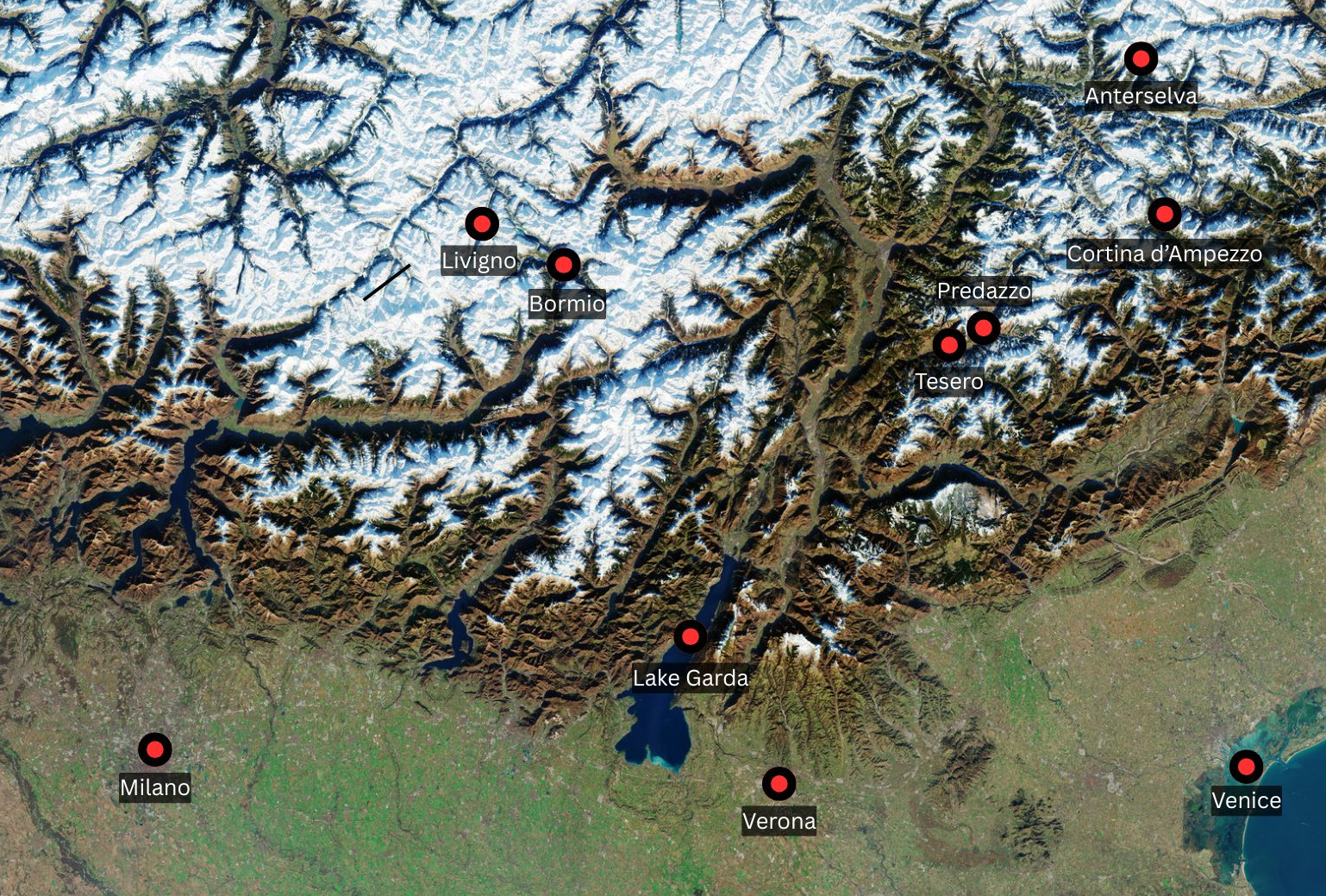
The European Space Agency has released a breathtaking view of northern Italy captured by its Copernicus Sentinel-2 mission. The images celebrate the opening day of the 2026 Milano-Cortina Winter Olympics on Feb. 6, as thousands of world-class athletes gather to seek gold among the mountains.
ESA‘s Copernicus-2 mission captured the scene from a sun-synchronous orbit 488 miles (786 kilometers) above Earth. The high-resolution imagery reveals a stunningly diverse landscape of snowy valleys threaded with a vein-like network of mountain peaks, around which sit the venues of the 2026 Winter Olympic Games.

To the bottom left is the urban sprawl of Milano — the second most populous city in Italy, while historic Verona sits to its right, close to the azure expanse of Lake Garda. The great lagoon containing the city of Venice is visible to the right, on the Adriatic coast.
Nestled among the alpine terrain to the north is the Italian town of Cortina d’Ampezzo, for which the 2026 Olympics is named. The orbital close-up featured below was captured by a satellite from the Italian IRIDE Hawk for Earth Observation (HEO) constellation on Feb. 1.

Often known as the “Pearl of the Dolomites” after the towering mountain range that surrounds it, Cortina d’Ampezzo will play host to a number of Olympic events over the coming weeks, including curling, alpine skiing and the sliding sports of bobsleigh, skeleton and luge.
What is it?
ESA’s Copernicus-2 mission is comprised of three satellites — Sentinel-2A, Sentinel-2B and Sentinel-2C — which systematically observe Earth’s landmasses and oceans using multispectral imager (MSI) instruments with a spatial resolution of up to 10 meters (32 feet)
Together, they are tasked with monitoring our planet’s forests, agriculture, land use, coastal waters and more, while also mapping disaster areas to aid emergency services during major flood, forest fire and earthquake events.
Check out our Copernicus Program explainer to find out more!


Related Posts


Stay Informed With the Latest & Most Important News
Previous Post
Next Post


Advertisement
-
 01Two Black Holes Observed Circling Each Other for the First Time
 -
 02From Polymerization-Enabled Folding and Assembly to Chemical Evolution: Key Processes for Emergence of Functional Polymers in the Origin of Life
 -
 03Astronomy 101: From the Sun and Moon to Wormholes and Warp Drive, Key Theories, Discoveries, and Facts about the Universe (The Adams 101 Series)
 -
 04True Anomaly hires former York Space executive as chief operating officer
 -
 05Φsat-2 begins science phase for AI Earth images
 -
 06Hurricane forecasters are losing 3 key satellites ahead of peak storm season − a meteorologist explains why it matters
 -
 07Binary star systems are complex astronomical objects − a new AI approach could pin down their properties quickly