
Now Reading: Engineering Behind EarthDaily: Solving for Global Daily Coverage, Scientific Quality, and High-Spectral Diversity
-
01
Engineering Behind EarthDaily: Solving for Global Daily Coverage, Scientific Quality, and High-Spectral Diversity

Engineering Behind EarthDaily: Solving for Global Daily Coverage, Scientific Quality, and High-Spectral Diversity
Broad-area change detection only matters if the measurement behind it is stable. In Earth observation, frequency without calibration creates volatility, and imagery without consistency erodes trust over time. EarthDaily was designed around a simple principle: global daily coverage must be paired with scientific rigor, spectral depth, and long-term measurement integrity. What follows is the engineering discipline required to make that standard a reality.
From conception to first launch in 2025, EarthDaily made a deliberate choice to invest the time required to build a mission people can trust, not just one that they can see.
Most commercial optical satellites are built around a single or limited number of primary imaging assemblies: a small number of optical paths delivering multispectral or hyperspectral data through a unified instrument.
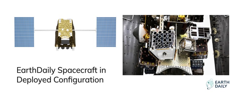
Our architecture required solving for sixteen imagers per spacecraft. This allows maintaining a consistent imaging geometry and consistent operating environment for the imagers which is important to maintain high data quality.
Each satellite integrates sixteen independent imaging assemblies operating in coordination. Sixteen focal planes. Sixteen alignment geometries. Sixteen thermal profiles. Sixteen radiometric responses operating under constant motion and changing illumination.
That architecture enables achieving the wide swath per satellite and limiting the number of satellites to 10 for the constellation to achieve global daily coverage where each must have very high pointing control and stability performance and precise orbit control performance. It also multiplies calibration complexity, particularly in thermal bands where performance must be continuously characterized to maintain measurement integrity.
Sixteen optical instruments do not behave identically. Thermal shifts, detector variability, and atmospheric effects introduce small differences that must be observed, modeled, and constrained until the system performs as a single coherent measurement system.
Across the planned ten-spacecraft constellation, that complexity scales to 160 coordinated imaging assemblies — effectively 160 single-instruments aligned into one integrated measurement system.
On the ground, those streams are aligned, calibrated, and harmonized into a single unified dataset.
Rigorous laboratory testing can only reveal so much. The true test comes on orbit, when hardware is pushed to its limits and external variables come into play.
The Origin: Built to Fill a Gap
To understand what has been built, it is necessary to understand the gap it was designed to solve.
Agriculture companies needed something that doesn’t exist: daily, scientifically reliable imagery with stable radiometry and geometry. They needed data they could trust at scale to support farmers and agronomic decisions.
That same gap is being felt across other industries: the geospatial market lacked a system capable of delivering daily, broad-area coverage with science-grade radiometric and geometric stability and relatively high resolution (e.g., 5 m). No commercial provider can deliver that combination of frequency, coverage, resolution, and scientific measurement rigor.
That requirement is the foundation of the EarthDaily Constellation — trust over time.
Our first concept focused on five core VNIR spectral bands at 5 m GSD with daily global land mass coverage aimed at agricultural monitoring. Our objective was repeatable, calibrated measurement across vast land areas and across seasons.
From that starting point, the spacecraft evolved into the 16 imager and 22-band design, covering a very broad spectral range that includes VNIR, SWIR and Thermal. The band selection was driven by measurement quality, atmospheric characterization, water vapor correction, improved cloud masking, and reliable separation of cloud from snow and the ability to accurately cross-calibrate to other ultra-high quality science satellites.
This spectral band combination provides for much improved image product quality and information richness important to many applications. Many of the bands are used to improve the ability to compensate for the atmosphere and to provide superior cloud masks.

A longer design life, higher quality, and continuously maintained orbit at the same time every day became crucial to achieving the core tenet of our mission: providing a consistent, science-grade foundation for long term change detection.

Agriculture was the forcing function that shaped the architecture; the philosophy scaled far beyond agriculture into many other applications.
A Launch is the Starting Gun, Not the Finish Line
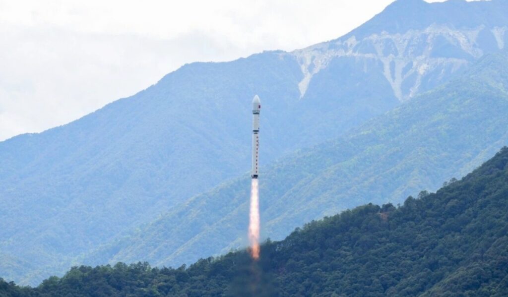
We launched our first satellite in June 2025. For a science-class mission, launch is not the milestone many assume. It is the starting gun for commissioning, calibration, validation, and processing pipeline hardening. We have been using this satellite to optimize our automated data processing and calibration pipelines and also our largely automated satellite operations architecture. A high level of autonomy is required since the constellation will be imaging at an enterprise scale with roughly one hundred terabytes per day acquired across tens of thousands of acquisitions.
Satellite bus and payload control, onboard data management, downlink, our ground systems and the global image acquisition coordination must function as a highly automated integrated system.

We launched the first satellite EDC-01 early to provide the opportunity to thoroughly check-out the satellite and optimize the onboard and ground automation software, characterize the imagers and prepare for high volume extensive calibration campaigns and to refine all operating procedures before our next batch of 6 satellites are launched (scheduled for May 2026).
Since the launch of EDC-01, we have undertaken the following:
- Thoroughly checked out all bus and payload subsystems and imagers
- Validated the constellation control and constellation management software and the ground processing technology stack
- Demonstrated sustained imaging operations for different imaging modes and satellite control modes
- Characterized the satellite imagery and optimizing the processing algorithms
- Optimizing the spacecraft and payload software and ground software to validate and improve our automation capability

Producing pixels is not the bar. Meeting scientific measurement quality — consistently and repeatedly — is. That is the standard we are focused on delivering to our data customers.
What Does an SLA Mean for Scientific Quality?
We designed EarthDaily to operate as a trusted digital infrastructure like other satellite technologies such as GPS and weather data, but for Earth observation — consistent, reliable, frequent, and repeatable. To do this requires achieving Sentinel-2 and Landsat-like scientific quality with a daily global revisit. In practical terms, that means operating under a defined Service Level Agreement (SLA) committing us to measurable thresholds for scientific performance.
In science missions, quality requirements are specific and backed by rigor: radiometric accuracy better than 5 percent, geometric quality better than 10 meters, and signal-to-noise ratios above 100 for most types of ground cover.
At EarthDaily, we set the bar high and design to these same measures:
- Radiometric accuracy: Better than 5 percent. This comes down to sensor design, pre-launch calibration, and in-orbit calibration, with satellite-to-satellite consistency better than half that. Every day we image the Earth’s landmass at the same time of day as many science missions, meaning their imagery becomes continual reference for our ongoing calibration and validation.
- Geolocation accuracy: Better than 10 meters (expect less than 5m in most situations). This is driven by focal plane and optical distortion calibration, basemap quality, and physics-based processing (not rubber sheeting) with AI-assisted ground control to inform our satellite and sensor model. We also create our own basemaps using rigorous global bundle adjustment to minimize errors and tie our maps with extreme precision.
- Signal-to-noise ratio (SNR): Better than 100 for most types of ground cover. We use a pushbroom sensor with Time Delayed Integration (TDI) to integrate signals across multiple lines (versus one), enabling high SNR and accurate measurement of subtle signals on the ground. This is the same sensor technology approach used by Sentinel-2 and Landsat and is well suited for scientific measurements.
Maintaining an SLA for scientific quality is not a one-time check. It requires continuous calibration and validation, with regular reporting that builds trust with customers.
Calibration isn’t a Checkbox
For EarthDaily, pre-launch characterization is not a single lab session with a broadband light source. It is a carefully designed campaign to map the response at every wavelength using tunable lasers conducted alongside instrument development, with NIST-traceable instrumentation.
That requires:
- Tunable laser systems
- Specialist physicists
- Controlled calibration facilities
- Detailed uncertainty modeling
We chose to work with world-class calibration partner L1 Technology because this level of rigor — truly understanding sensor performance at a fundamental level — is what makes data comparable across time, satellites, and geography. Their experience includes trusted scientific missions at NASA and NOAA, and that rigor is necessary to meet our customer requirements.

The result is analytics that do not quietly degrade as sensors drift, viewing angles vary, imaging time shifts, or the constellation evolves. Calibration is not overhead. It is the foundation of trust.
Thermal: Where Physics is Unforgiving
Thermal imaging adds another layer of complexity.
In thermal, everything is temperature dependent until characterized. Everything is stray light until proven otherwise. Every deviation between model and reality must be measured and reconciled.
Detecting a thermal signal is easy. Measuring it accurately — in a stable fashion and consistently across environments — is not.
We have worked closely with our partners such as ABB and INO to deeply characterize the imager’s behavior, supported by the Canadian Space Agency and using innovative in-orbit calibration efforts.
We have analyzed millions of global calibration sites to maintain stability over time. We cross-calibrate our system daily against eight science missions. Any drift, no matter how small, is monitored continuously and corrected.
Thermal performance is not about producing dramatic images. It is about ensuring that a temperature change measured today means the same thing six months, or ten years, from now.


Manufacturing: ‘Good Enough’ isn’t Good Enough
Space hardware rarely behaves exactly as expected. Bonding tolerances, structural stress, alignment deviations, subtle deformations — these are the realities of building precision systems.
In one instance, rigorous testing identified excess stress in part of the optical system, causing minute deformation and a measurable impact on image sharpness. To detect even the smallest anomalies in resolution, we developed automated validation processes with ABB to precisely measure sensor performance.
The degradation would have been subtle. It may have been difficult for many users to notice. It would have been faster to keep moving forward and launch.
Instead, we stopped, redesigned, and requalified as necessary.
That is the difference between iteration-driven missions and measurement-driven missions. In a fail-fast world, you fly and fix later. In a science-class mission, you fix before flight, because reliability defines value. In other missions, the strategy is to launch satellites over time and improve as you go.
For EarthDaily, it is the global daily coverage that brings the full value from the beginning of the mission and the spacecraft must be designed right the first time to ensure the high quality over the full lifetime. Hence, it is imperative that the design and manufacturing and calibration process produces the quality that we need to meet our customers requirements.

For many commercial systems, ground sampling distance and true spatial resolution are not the same thing. A nominal five-meter system does not always deliver five-meter performance. Our system meets specification as a true five-meter system.
For some visual applications, optional physics-based point spread function (PSF) sharpening can be applied, trading some signal-to-noise ratio for increased apparent sharpness. At native five meters, the data is already optimized for analytical stability and AI applications.
The Ground Segment is Half the Mission
Space hardware gets the headlines. Ground systems determine whether the mission actually works.
Orbit is only half the problem. The other half is transforming raw pixels into stable, analysis-ready measurements at scale. Many commercial space companies focus primarily on the spacecraft, while the ground segment becomes an afterthought.
EarthDaily is not a hardware manufacturer. We partner with industry leaders for spacecraft and payload systems. Our focus has been building the ground segment as a first-class product. Our ground segment innovation includes:
- Automated calibration pipelines
- Atmospheric correction
- Cloud, shadow, and haze masking
- Analysis Ready Data (ARD) compliance
- Quality assurance automation at scale
- Archiving and distribution systems built for enterprise workloads
We have already demonstrated this discipline using public satellite data, including Sentinel-2 and Landsat, producing AI-ready mosaics and building processing systems that will carry forward to EarthDaily data. As we build our scientific mission, we stand on the shoulders of those giants — their open data enabled calibration and validation of our processing architecture.
Because our processing system is aligned with major science missions from the start, interoperability and consistency are built in rather than added later.
The goal is not to release static images that look impressive. The goal is to deliver a continuously reliable, stable data infrastructure for change detection and forecasting.


Releasing Data as a Quality Milestone
If customers build models, analytics, or operational systems on data that later shifts — due to recalibration, processing changes, or stability improvements — the downstream cost is significant.
Archives must be reprocessed; models retrained; analytics revalidated; and baselines adjusted. Those costs compound.
We are treating data release as a quality milestone, not simply a “we have pixels” milestone. The objective is to address the 80/20 reality most data scientists face: too much time correcting, normalizing, masking clouds, and transforming imagery, and too little time building applications.
We know this problem because we have experienced it.
Cloud masking illustrates the point. Even with high-quality public missions such as Sentinel-2, subtle clouds and haze can escape detection, leading to false positives in change detection.
We have developed an AI-based cloud masking solution using Sentinel-2 and Landsat-8/9 that will be applied directly to EarthDaily data to label cloud, shadow, and haze more precisely.


The objective is not incremental improvement over time. It is to deliver stable, analysis-ready measurement from the start.
What You’ll Get When We Press ‘Publish’
When EarthDaily data becomes fully operational, it will deliver:
- Daily global land coverage
- Visible, near-infrared, short-wave infrared, and thermal bands (beginning with VNIR)
- Nadir, consistent viewing geometry and accurate geolocation
- Stable time-of-day acquisition
- Identical, scientifically calibrated sensors across the constellation
- A ten-year design life built for long-term continuity
There is no tasking required over land; coverage is continuous.
Over oceans, we maintain tens of millions of square kilometers of additional daily capacity for maritime tasking. Demand for persistent data is clear, and customers are already securing coverage.

The objective is not to produce isolated, spectacular images. It is to provide a continuous, stable measurement system — a data infrastructure for change detection, forecasting, risk management, environmental monitoring, and AI-driven insight. Infrastructure, not simply imagery.
Built for Measurement, Not Moments
There are different ways to build in space. Some missions are designed to build, launch, learn, and iterate. Others obsess over traceability, uncertainty budgets, calibration campaigns, and long-term measurement stability.
From the beginning, EarthDaily chose the latter.
When customers build analytics, risk models, and automated decisions on your data, you don’t get to “ship it and patch it later.” The payload, calibration, algorithms, and ground segment must align from Day 1 — and they must hold steady.
That philosophy takes time.


Related Posts
Stay Informed With the Latest & Most Important News
Previous Post
Next Post


Advertisement
-
 01Two Black Holes Observed Circling Each Other for the First Time
 -
 02From Polymerization-Enabled Folding and Assembly to Chemical Evolution: Key Processes for Emergence of Functional Polymers in the Origin of Life
 -
 03Astronomy 101: From the Sun and Moon to Wormholes and Warp Drive, Key Theories, Discoveries, and Facts about the Universe (The Adams 101 Series)
 -
 04True Anomaly hires former York Space executive as chief operating officer
 -
 05Φsat-2 begins science phase for AI Earth images
 -
 06Hurricane forecasters are losing 3 key satellites ahead of peak storm season − a meteorologist explains why it matters
 -
 07Binary star systems are complex astronomical objects − a new AI approach could pin down their properties quickly