
Now Reading: Earth from Space: Jostedalsbreen, Norway
-
01
Earth from Space: Jostedalsbreen, Norway

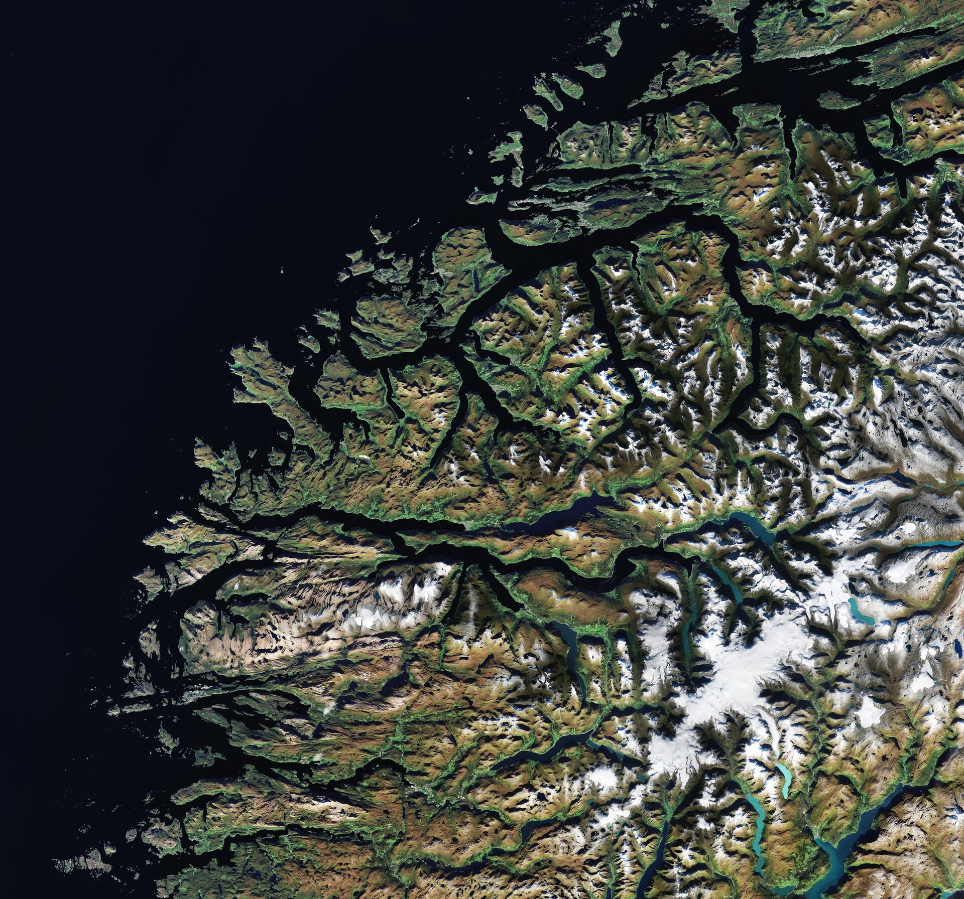

Ahead of the World Day for Glaciers, Copernicus Sentinel-2 captures the diverse landscape of western Norway with its jagged fjords, fertile valleys, mountain plateaus and Jostedalsbreen, the largest glacier in continental Europe.
Zoom in to explore this image at its full 10 m resolution.
On the western half of the Scandinavian Peninsula, Norway is famed for its pristine fjords. In this image, these long narrow marine inlets are visible as deeply indented dark lines stretching inland from the coastline.
The fjords, bordered by steep cliffs, were created by glacial erosion during previous ice ages, when ice and rivers carved deep valleys in the mountains. As the climate changed, most of the ice melted and the valleys were gradually filled with sea water.
After the last ice age, not all the ice melted and parts of the mountains maintained their ice coverage, creating glaciers. The large white expanse visible on the right side of the image is the Jostedalsbreen National Park, one of the largest in Norway. Approximately half of the national park’s area consists of glaciers and Jostedalsbreen is the largest, spanning between 450 and 480 sq km.
Jostedalsbreen is a plateau glacier, or an ice cap, that sits on top of a high-altitude plateau and covers a series of mountain peaks, the highest of which is the Lodalskåpa at an elevation of 2083 m above sea level. Jostedalsbreen feeds numerous outlet glaciers in all directions that then flow down into the valleys.
Glaciers and ice caps are essential to Earth’s ecosystem, providing freshwater resources and supporting agriculture, industry and biodiversity. Climate change is causing glaciers and ice sheets around the world to melt and shrink. As temperatures rise, melting depletes regional freshwater supplies and drives global sea levels to rise at ever-faster rates, with potentially devastating consequences in the long term.
The World Day for Glaciers aims to raise awareness of the crucial role of glaciers around the world and to encourage everyone to act to preserve these vital resources.Observations from satellites orbiting Earth can greatly contribute to the precise monitoring of glacier change to support informed adaptation decisions for the future.


Related Posts
Stay Informed With the Latest & Most Important News
Previous Post
Next Post


Advertisement
-
 01Two Black Holes Observed Circling Each Other for the First Time
 -
 02From Polymerization-Enabled Folding and Assembly to Chemical Evolution: Key Processes for Emergence of Functional Polymers in the Origin of Life
 -
 03Astronomy 101: From the Sun and Moon to Wormholes and Warp Drive, Key Theories, Discoveries, and Facts about the Universe (The Adams 101 Series)
 -
 04True Anomaly hires former York Space executive as chief operating officer
 -
 05Φsat-2 begins science phase for AI Earth images
 -
 06Hurricane forecasters are losing 3 key satellites ahead of peak storm season − a meteorologist explains why it matters
 -
 07Binary star systems are complex astronomical objects − a new AI approach could pin down their properties quickly