
Now Reading: Revealing the Internal Structure of Mars-Analog Glaciers From Drone-Based Radar Sounding
-
01
Revealing the Internal Structure of Mars-Analog Glaciers From Drone-Based Radar Sounding

Revealing the Internal Structure of Mars-Analog Glaciers From Drone-Based Radar Sounding

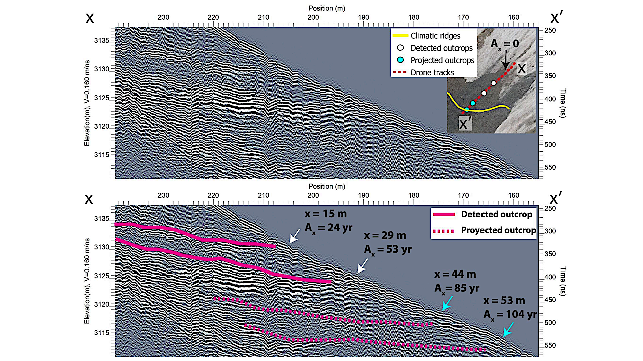
Terrain corrected DGPR profile at Galena Creek Rock Glacier. Location of the profile is shown in Fig. 3A. Uninterpreted data (top) and interpreted internal debris layers (bottom), with detected and projected outcrops, and their corresponding distance to the snowfield (x) and age of formation (Ax). The map shown in the top panel contains the drone-derived orthomosaic from 2022 (5 cm/px), underlying the outcropping location of internal debris layers and climatic ridge 56th LPSC (2025)
Debris-covered glaciers (DCGs) at the mid latitudes of Mars preserve ice accumulated in multiple episodes of high obliquity during the Amazonian age. The englacial debris layers formed during interglacials are of interest for astrobiological and paleoclimate studies. However, retrieving detailed internal stratigraphy with NASA’s Shallow Radar (SHARAD, 15-25 MHz remains challenging.
Following the success of the Ingenuity Mars helicopter, drones have emerged as a promising platform for future geophysical surveys on Mars. In prior work on terrestrial analogs for Martian DCGs, we showed that a drone-based ground penetrating radar (DGPR) can effectively resolve glacier bulk depth and supraglacial debris thickness—a critical parameter for in-situ resource utilization (ISRU) of water].
In this study, we evaluated the DGPR’s capability to map the near-surface layering in the cirque of Galena Creek Rock Glacier, a terrestrial DCG previously surveyed with surface-based GPR. By combining the DGPR subsurface mapping with repeated drone photogrammetry, we calculated the age of englacial debris layers and analyzed the relationship of their outcropping locations with traverse-flow surface ridges.
Revealing the Internal Structure of Mars-Analog Glaciers From Drone-Based Radar Sounding, Roberto J. Aguilar et al., 56th LPSC (2025)
Astrobiology, Astrogeology,


Related Posts
Stay Informed With the Latest & Most Important News
Previous Post
Next Post


Advertisement
-
 01Two Black Holes Observed Circling Each Other for the First Time
 -
 02From Polymerization-Enabled Folding and Assembly to Chemical Evolution: Key Processes for Emergence of Functional Polymers in the Origin of Life
 -
 03Astronomy 101: From the Sun and Moon to Wormholes and Warp Drive, Key Theories, Discoveries, and Facts about the Universe (The Adams 101 Series)
 -
 04True Anomaly hires former York Space executive as chief operating officer
 -
 05Φsat-2 begins science phase for AI Earth images
 -
 06Hurricane forecasters are losing 3 key satellites ahead of peak storm season − a meteorologist explains why it matters
 -
 07Binary star systems are complex astronomical objects − a new AI approach could pin down their properties quickly