
Now Reading: A satellite just captured images of a tsunami being born. Here’s why that’s a big deal
-
01
A satellite just captured images of a tsunami being born. Here’s why that’s a big deal

A satellite just captured images of a tsunami being born. Here’s why that’s a big deal
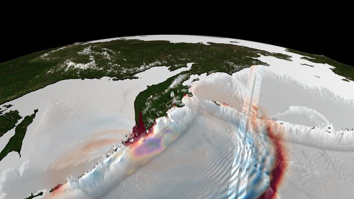
Late on July 29, 2025, the Earth’s crust off of Russia’s Kamchatka Peninsula ruptured. Deep beneath the Pacific, along a subduction zone where one tectonic plate dives beneath another, a strain that had built up over decades was released in seconds. That rupture, a powerful magnitude 8.8 earthquake, displaced the seafloor and the water column above it, resulting in a tsunami. The tsunami radiated outward across the Pacific, racing across the open ocean as fast as an airplane and eventually surging onto the shore, reaching heights exceeding 55 feet (17 meters).
Scientists have long understood this chain reaction, but a detailed look at how an earthquake-tsunami event unfolds at the source — a subduction-zone trench — has remained difficult to achieve. There aren’t enough tsunami-monitoring sensors near the trenches to get a clear look.
Rather than relying on purpose-built tsunami detection systems alone, researchers are increasingly turning to existing satellite missions and finding novel ways to use them. NASA and the French Space Agency’s Surface Water and Ocean Topography (SWOT) satellite, originally designed to study global water levels and ocean circulation, is now proving to be a powerful tool for tsunami science as well.
A team of researchers led by Ignacio Sepúlveda of San Diego State University, used SWOT to observe the Kamchatka tsunami, and their resulting work gives an unusually clear view into tsunamigenesis, or the birth of a tsunami. Using satellite data, tsunami and earthquake researchers can better model — and hopefully better forecast — these extreme ocean events.
Sepúlveda, who leads the SDSU Coastal Engineering Lab, has long used satellites to study ocean events. Because previous tsunami research tapped into SWOT for observations, Sepúlveda and his researchers knew they could use the satellite to see the Kamchatka event — and they had something of a lucky break.
Just 70 minutes after the earthquake, SWOT passed over the Pacific roughly 375 miles (600 km) from the epicenter, imaging in high detail not only the tsunami’s leading wave, but also a train of smaller waves trailing behind it.
As the team attempted to simulate the 2025 Kamchatka event, they ran into a problem. “When we reproduced the tsunami using our simplest model, the long-wave model that everybody uses extensively, we saw that the model was not reproducing all the properties that were observed by SWOT,” Sepúlveda told Space.com.
The issue was those trailing waves, called dispersive waves. The long-wave model simply doesn’t account for them, since dispersive waves are not easily observed with existing technology.
Traditional tsunami monitoring relies heavily on Deep-ocean Assessment and Reporting of Tsunamis (DART) buoys, which measure pressure changes at the seafloor. While crucial for tsunami warnings, these sensors are limited in what they can detect. DART buoys provide measurements at single points, so it’s impossible to “see” the full structure of a tsunami.
By contrast, SWOT offers a wide, two-dimensional view of the ocean surface, capturing wave direction, spacing, and curvature with centimeter-level precision. “Here, we have extra information coming from the satellite that we are not commonly getting from other types of instruments,” said Sepúlveda. “With that 2D image, you are able to characterize very well what happened with the tsunami’s leading wave and the trailing waves.”

Sepúlveda and his team realized they needed to use a different model — the more sophisticated Boussinesq-type model — to correctly reproduce the SWOT observations of the Kamchatka tsunami. That broader perspective allowed researchers to identify a key insight: the dispersive waves carry information about where the tsunami originated. Now, the team was able to pinpoint tsunamigenesis to within about six miles (10 km) of the trench, marking such a close-up view for the first time ever.
The findings mark a turning point in tsunami science. For the first time, scientists have direct, high-resolution, two-dimensional observations linking a tsunami’s structure in the open ocean to the details of the earthquake that created it. “In the long term, we will improve our models because we will start to know much better what is going on in that near-trench area,” said Sepúlveda.
By improving how scientists model tsunami generation — particularly the elusive near-trench processes, which produce some of the most dangerous tsunamis — these observations can help refine forecasting systems. Better models mean more accurate predictions of wave height, timing, and impact at coastlines. And when used in conjunction with other monitoring tools like DART buoys, that could translate into faster warnings, better evacuations and lives saved when the next major tsunami strikes.


Related Posts


Stay Informed With the Latest & Most Important News
Previous Post
Next Post


Advertisement
-
 01Two Black Holes Observed Circling Each Other for the First Time
 -
 02From Polymerization-Enabled Folding and Assembly to Chemical Evolution: Key Processes for Emergence of Functional Polymers in the Origin of Life
 -
 03Astronomy 101: From the Sun and Moon to Wormholes and Warp Drive, Key Theories, Discoveries, and Facts about the Universe (The Adams 101 Series)
 -
 04True Anomaly hires former York Space executive as chief operating officer
 -
 05Φsat-2 begins science phase for AI Earth images
 -
 06Hurricane forecasters are losing 3 key satellites ahead of peak storm season − a meteorologist explains why it matters
 -
 07Binary star systems are complex astronomical objects − a new AI approach could pin down their properties quickly