
Now Reading: Satellite Image Reveals Significant Eruption of Piton de la Fournaise Volcano on Réunion Island
-
01
Satellite Image Reveals Significant Eruption of Piton de la Fournaise Volcano on Réunion Island

Satellite Image Reveals Significant Eruption of Piton de la Fournaise Volcano on Réunion Island
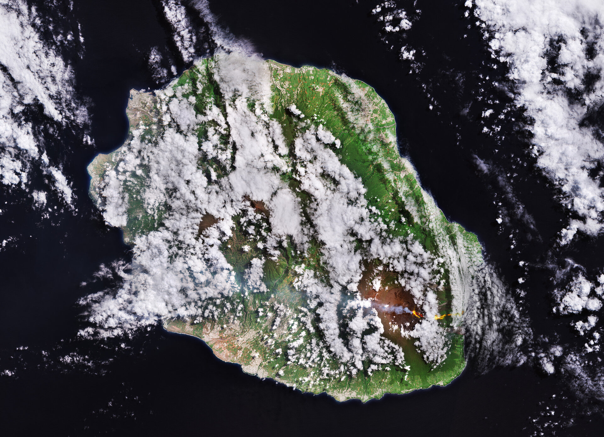

A striking satellite image from the Copernicus Sentinel-2 mission has captured the ongoing eruption of the Piton de la Fournaise volcano on Réunion Island, enhancing our understanding of volcanic activity in this remote region. Situated in the western Indian Ocean, approximately 680 kilometers east of Madagascar, Réunion is a French overseas department known for its dramatic volcanic landscape, characterized by steep terrain and lush greenery interspersed with settlements and farmland concentrated in its coastal areas. The island’s capital, Saint-Denis, is situated on the northern coast but is mostly obscured by cloud cover in the image.
At the heart of the island lies the Piton des Neiges, the highest peak at 3,069 meters, which is part of a dormant shield volcano system formed by extensive geological collapses known as calderas. Although Réunion is home to several volcanoes, the Piton de la Fournaise remains its only active one, notable for its frequent eruptions that significantly impact the local landscape. The recent eruption, which commenced in mid-February, is highlighted in an image dated March 21, 2026, showcasing a vivid flow of lava cascading down its western slopes.
This eruption marks a significant moment, as lava has reached the ocean for the first time in nearly twenty years, visible in the image as it flows toward the coastline and ultimately spills into the Indian Ocean. The vibrant hues of yellow and red in the image denote the active lava, while additional plumes of ash and smoke rise from the crater, drifting westward. The darker patches of solidified lava on the volcano’s flanks testify to previous eruptions, underscoring the active geological history of the site.
Satellite imagery plays an important role in monitoring volcanic eruptions, providing timely updates on lava flows and ash clouds, which can be essential for assessing threats to nearby communities. The Copernicus Sentinel-2, equipped with both optical and shortwave infrared channels, serves as a vital tool in this effort, capturing detailed information about the ongoing volcanic activity. Furthermore, supplementary radar instruments and atmospheric sensors enhance this capability, enabling the detection of ground fissures, potential seismic activity, and the measurement of gas emissions, which together inform assessments of the eruption’s environmental impacts and risks to air travel. As scientists and local authorities closely monitor this stunning yet perilous natural phenomenon, the technology harnessed in these satellite observations continues to play an indispensable role in understanding and mitigating the effects of volcanic eruptions.


Related Posts
Stay Informed With the Latest & Most Important News


Advertisement
-
 01Two Black Holes Observed Circling Each Other for the First Time
 -
 02From Polymerization-Enabled Folding and Assembly to Chemical Evolution: Key Processes for Emergence of Functional Polymers in the Origin of Life
 -
 03Astronomy 101: From the Sun and Moon to Wormholes and Warp Drive, Key Theories, Discoveries, and Facts about the Universe (The Adams 101 Series)
 -
 04True Anomaly hires former York Space executive as chief operating officer
 -
 05Φsat-2 begins science phase for AI Earth images
 -
 06Hurricane forecasters are losing 3 key satellites ahead of peak storm season − a meteorologist explains why it matters
 -
 07Binary star systems are complex astronomical objects − a new AI approach could pin down their properties quickly