
Now Reading: Smoke Shrouds Northern Thailand
-
01
Smoke Shrouds Northern Thailand


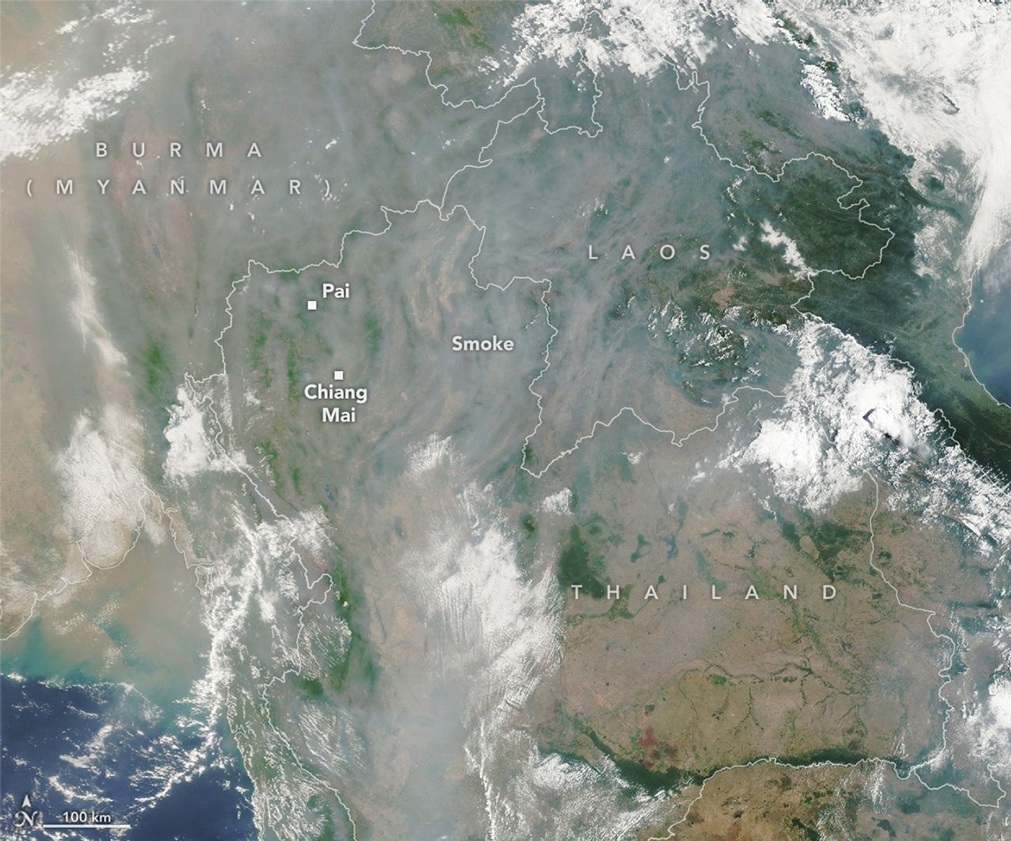
Chiang Mai, Thailand’s second-largest city, lies within a network of narrow valleys in the country’s northern highlands. Though the historic city is known for panoramic views of the surrounding mountains, clear skies have become less common. In recent decades, smoke has increasingly darkened the skies during the dry season, particularly in March and April.
A NASA satellite captured this smoky view of the city and the surrounding region on April 22, 2026, when haze partially obscured valleys and ridges typically visible under clearer conditions. Most of the smoke likely comes from small agricultural and forest fires lit to burn off crop debris or maintain forest ecosystems. In 2026, satellite sensors detected small numbers of fires throughout January, but fire detections became more numerous and widespread in February, March, and April. Fire activity typically peaks in March and fades by May as seasonal rains increase.
Research indicates that smoke from biomass burning is one of the largest contributors to poor air quality in northern Thailand during the dry season. By one estimate, about 70 percent of fine particulate matter (PM2.5) in Chiang Mai in April comes from biomass burning. Smaller contributors to the region’s hazy skies include vehicles, power plants and industry, and charcoal burning for cooking and heating. Geography also plays a key role; the surrounding mountains block air flow and encourage temperature inversions that trap both local pollution and haze from the broader region in the valleys.
On the same day the satellite image was captured, air quality sensors on the ground recorded “unhealthy” and “very unhealthy” levels of PM2.5 air pollution throughout Chiang Mai and the region, according to data from the World Air Quality Index project. Prolonged exposure to high levels of air pollution can contribute to respiratory and cardiovascular diseases and other health problems.
News reports suggest that the haze is affecting the tourism industry and has contributed to a decrease in the number of international travelers coming to Chiang Mai. After more than a month of persistent haze, the number of tourists arriving in the town of Pai, a popular destination for backpackers northwest of Chiang Mai, was down 90 percent, according to one local newspaper.
Unusually warm and dry conditions have gripped the region in recent weeks, according to meteorologists with the ASEAN Specialised Meteorological Centre (ASMC). On March 27, the group advised that there was a “high risk” of severe transboundary haze in the region and elevated its alert level to three, the highest on the scale.
In late March, the group noted that dry conditions were forecast to persist over most parts of the Mekong sub-region, with prevailing winds expected to blow mostly from the south or southwest. “Under these conditions,” ASMC noted, “the hotspot and smoke haze situation could escalate further.”
NASA Earth Observatory image by Lauren Dauphin, using MODIS data from NASA EOSDIS LANCE and GIBS/Worldview. Story by Adam Voiland.

References & Resources
- ASMC (2026) Regional Haze Situation. Accessed April 22, 2026.
- Bangkok Post (2026, April 17) Pai tourism suffers as haze grips North. Accessed April 22, 2026.
- NASA Earthdata (2026, April 10) Stagnant Skies in Southeast Asia. Accessed April 22, 2026.
- NASA Earth Observatory (2024, April 8) Hazy Skies in a Growing City. Accessed April 22, 2026.
- NASA Earth Observatory (2024, April 1) Grappling with Thailand’s Seasonal Haze. Accessed April 22, 2026.
- The Nation (2026, April 18) Northern wildfire surge pushes Thailand hotspots to 2026 high. Accessed April 22, 2026.
- Pani, S., et al. (2020) Black carbon over an urban atmosphere in northern peninsular Southeast Asia: Characteristics, source apportionment, and associated health risks. Environmental Pollution, 259, 113871.
- Pirard, C. & Charoenpanwutikul, A. (2023) Comprehensive review of the annual haze episode in Northern Thailand. Earth ArXiv preprint.
- Orion (2025, February 12) Where There is Smoke. Accessed April 22, 2026.
You may also be interested in:
Stay up-to-date with the latest content from NASA as we explore the universe and discover more about our home planet.

Scientists say the seasonal crop fires are burning later in the day than in previous years.

Villages and farmland were swamped after unusually heavy early-February rains pushed the Sinú River over its banks.

Satellite-based maps show northern wildland fires becoming more frequent and widespread as temperatures rise and lightning reaches higher latitudes.


Related Posts

Stay Informed With the Latest & Most Important News
Previous Post
Next Post


Advertisement
-
 01Two Black Holes Observed Circling Each Other for the First Time
 -
 02From Polymerization-Enabled Folding and Assembly to Chemical Evolution: Key Processes for Emergence of Functional Polymers in the Origin of Life
 -
 03Astronomy 101: From the Sun and Moon to Wormholes and Warp Drive, Key Theories, Discoveries, and Facts about the Universe (The Adams 101 Series)
 -
 04True Anomaly hires former York Space executive as chief operating officer
 -
 05Φsat-2 begins science phase for AI Earth images
 -
 06Hurricane forecasters are losing 3 key satellites ahead of peak storm season − a meteorologist explains why it matters
 -
 07Binary star systems are complex astronomical objects − a new AI approach could pin down their properties quickly