
Now Reading: A Computer Vision Framework For Estimating Surface Habitability From Mars Using Convolutional Analysis
-
01
A Computer Vision Framework For Estimating Surface Habitability From Mars Using Convolutional Analysis

A Computer Vision Framework For Estimating Surface Habitability From Mars Using Convolutional Analysis
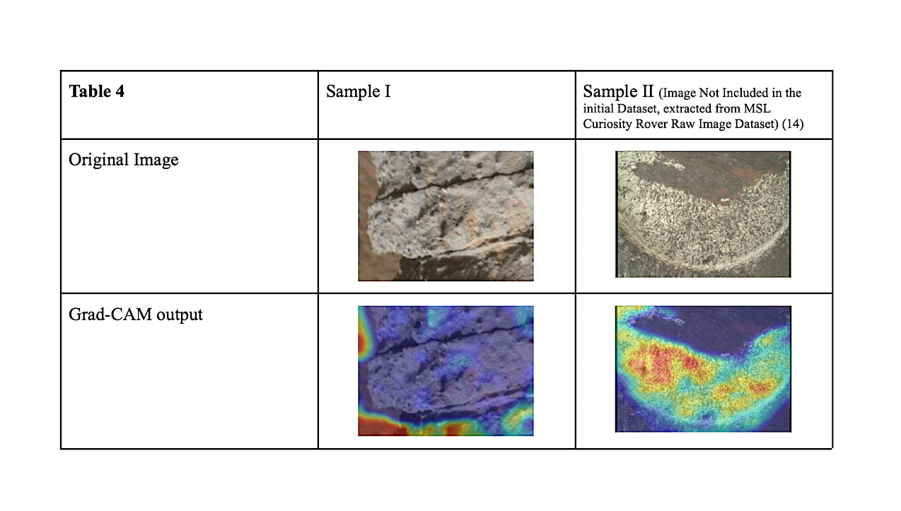

For the second stage of our analysis pipeline, outputs were further evaluated using a livability index L (scaled between 0 and 1). Among the 51 Mars-positive samples, the mean livability index was 0.417, with scores clustering at a midrange band of 0.31-0.48 (Table 5). These results suggest that most images were neutrally classified with the model neither stating high nor low livability rates across the tested data. Dust warnings were found to be common, with twenty-four samples flagged as “Warning” , twenty-five as “Caution” , and two as “Severe” (Table 6). — eartharxiv.org
Identifying signs of life in extraterrestrial environments is one of the growing challenges in planetary science. Conventional approaches of detecting habitability rely heavily on direct contact with biosignatures or geological analyses, but limited data and mission costs hold back such methods.
This work introduces a computer vision-based pipeline that analyzes planetary surface images to determine a livability index that estimates the photographed terrain’s likelihood to support life.
The data is from the Mars Surface Image Dataset (collected by NASA’s Curiosity Rover) and the Mars Handlens Analog Database (archived at the PDS Geosciences Node of Washington University in St. Louis).
Unlike existing binary classifiers that only distinguish between planetary sources, our method utilizes feature extraction to evaluate environments in terms of their habitability. By combining convolutional features with descriptors of texture, hue, and structure, we demonstrate that our model can move beyond simple classification and instead generate interpretable, probabilistic estimates of habitability.
With a livability index, we can focus on key habitability features and use them to guide targeted exploration to better search for life beyond Earth.
A Computer Vision Framework for Estimating Surface Habitability from Mars Using Convolutional Analysis, eartharxiv.org (open access)
Astrobiology,


Related Posts
Stay Informed With the Latest & Most Important News


Advertisement
-
 01Two Black Holes Observed Circling Each Other for the First Time
 -
 02From Polymerization-Enabled Folding and Assembly to Chemical Evolution: Key Processes for Emergence of Functional Polymers in the Origin of Life
 -
 03Astronomy 101: From the Sun and Moon to Wormholes and Warp Drive, Key Theories, Discoveries, and Facts about the Universe (The Adams 101 Series)
 -
 04True Anomaly hires former York Space executive as chief operating officer
 -
 05Φsat-2 begins science phase for AI Earth images
 -
 06Hurricane forecasters are losing 3 key satellites ahead of peak storm season − a meteorologist explains why it matters
 -
 07Binary star systems are complex astronomical objects − a new AI approach could pin down their properties quickly