
Now Reading: A Global High-Resolution Hydrological Model to Simulate the Dynamics of Surface Liquid Reservoirs: Application on Mars
-
01
A Global High-Resolution Hydrological Model to Simulate the Dynamics of Surface Liquid Reservoirs: Application on Mars

A Global High-Resolution Hydrological Model to Simulate the Dynamics of Surface Liquid Reservoirs: Application on Mars
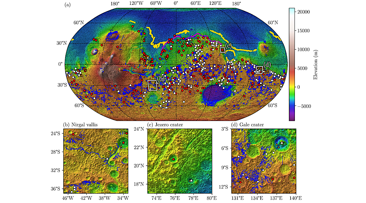

Mars topographic map showing the inventory of observed data relating to water flow effects. (a) Digital Elevation Model (DEM) from the Mars Orbiter Laser Altimeter (MOLA) (Smith et al., 2001; Neumann et al., 2001). The shaded relief is generated from the DEM with a sun angle of 45° from horizontal and a sun azimuth of 315°, as measured clockwise from north. The blue lines represent the valley networks (Hynek et al., 2010). The white and red dots represent open-basin and closed-basin lakes, respectively (Goudge et al., 2016). The orange triangles represent deltas (Di Achille and Hynek, 2010). The magenta and yellow lines represent respectively Arabia (Perron et al., 2007) and Deuteronilus (Ivanov et al., 2017) shorelines. The white squares are zoomed areas on Nirgal Vallis’ watershed (b), Jezero’ watershed (c) and Gale’ watershed (d). The white stars on the zoomed areas indicate the outlets of Nirgal Vallis (b), Jezero Crater (c), and Gale Crater (d). — astro-ph.EP
Surface runoff shapes planetary landscapes, but global hydrological models often lack the resolution and flexibility to simulate dynamic surface water bodies beyond Earth. Recent studies of Mars have revealed abundant geological and mineralogical evidence for past surface water, including valley networks, crater lakes, deltas and possible ocean margins dating from late Noachian to early Hesperian times.
These features suggest that early Mars experienced periods allowing liquid water stability, runoff and sediment transport. To investigate where surface water could accumulate and how it may have been redistributed, we developed a global high-resolution (km-scale) surface hydrological model.
The model uses a pre-computed hydrological database that maps topographic depressions, their spillover points, hierarchical connections between basins, and lake volume-area-elevation relationships. This database approach greatly accelerates simulations by avoiding repeated geomorphic processing.
The model dynamically forms, grows, merges and dries lakes and putative seas without prescribing fixed coastlines, by transferring water volumes between depressions according to their storage capacities and overflow rules.
We explore model behavior over the present-day Mars’ topography measured by MOLA (Mars Orbiter Laser Altimeter) topography for a range of evaporation rates (from 0.1 m/yr to 10 m/yr) and total water inventories expressed as Global Equivalent Layer (from 1 mGEL to 1000 mGEL). 48 Simulations are iterated to reach the steady state.
The model outputs the extent and depth of surface water bodies and identifies main drainage pathways using overflow fluxes as runoff indicators. Results show a transition toward a contiguous northern ocean between low (1-10 m) GEL values and increasing concentration of water in northern lowlands and major impact basins at higher GEL.
Alexandre Gauvain, François Forget, Martin Turbet, Jean-Baptiste Clément, Lucas Lange, Romain Vandemeulebrouck
Subjects: Earth and Planetary Astrophysics (astro-ph.EP)
Cite as: arXiv:2603.04206 [astro-ph.EP] (or arXiv:2603.04206v1 [astro-ph.EP] for this version)
https://doi.org/10.48550/arXiv.2603.04206
Focus to learn more
Related DOI:
https://doi.org/10.5194/egusphere-2025-4992
Focus to learn more
Submission history
From: Alexandre Gauvain
[v1] Wed, 4 Mar 2026 15:50:52 UTC (42,300 KB)
https://arxiv.org/abs/2603.04206
Astrobiology,


Related Posts
Stay Informed With the Latest & Most Important News
Previous Post
Next Post


Advertisement
-
 01Two Black Holes Observed Circling Each Other for the First Time
 -
 02From Polymerization-Enabled Folding and Assembly to Chemical Evolution: Key Processes for Emergence of Functional Polymers in the Origin of Life
 -
 03Astronomy 101: From the Sun and Moon to Wormholes and Warp Drive, Key Theories, Discoveries, and Facts about the Universe (The Adams 101 Series)
 -
 04True Anomaly hires former York Space executive as chief operating officer
 -
 05Φsat-2 begins science phase for AI Earth images
 -
 06Hurricane forecasters are losing 3 key satellites ahead of peak storm season − a meteorologist explains why it matters
 -
 07Binary star systems are complex astronomical objects − a new AI approach could pin down their properties quickly