
Now Reading: A Volcanic Medley Near Mammoth Lakes
-
01
A Volcanic Medley Near Mammoth Lakes


Take a tour through volcanic history on the edge of the Sierra Nevada near Mammoth Lakes, California. Between the tall granite peaks to the west and the Basin and Range province to the east, overlapping volcanic complexes imprint the landscape with a collection of craters, cones, and calderas. The area, still restless today, draws interest from geologists studying Earth’s processes and from planetary scientists exploring its commonalities with volcanic terrain elsewhere in our solar system.
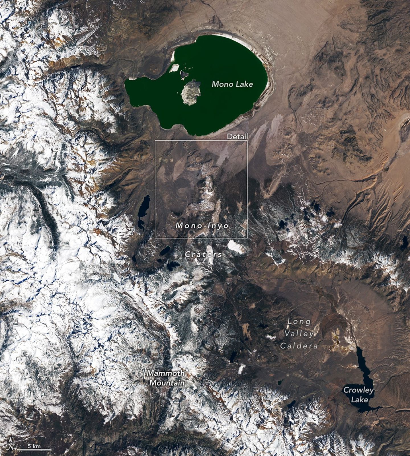
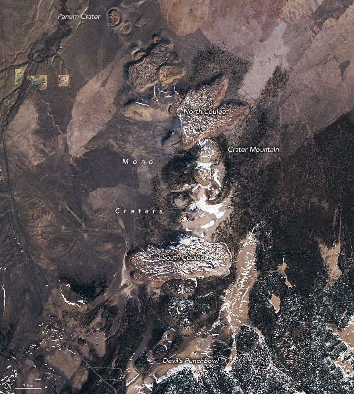
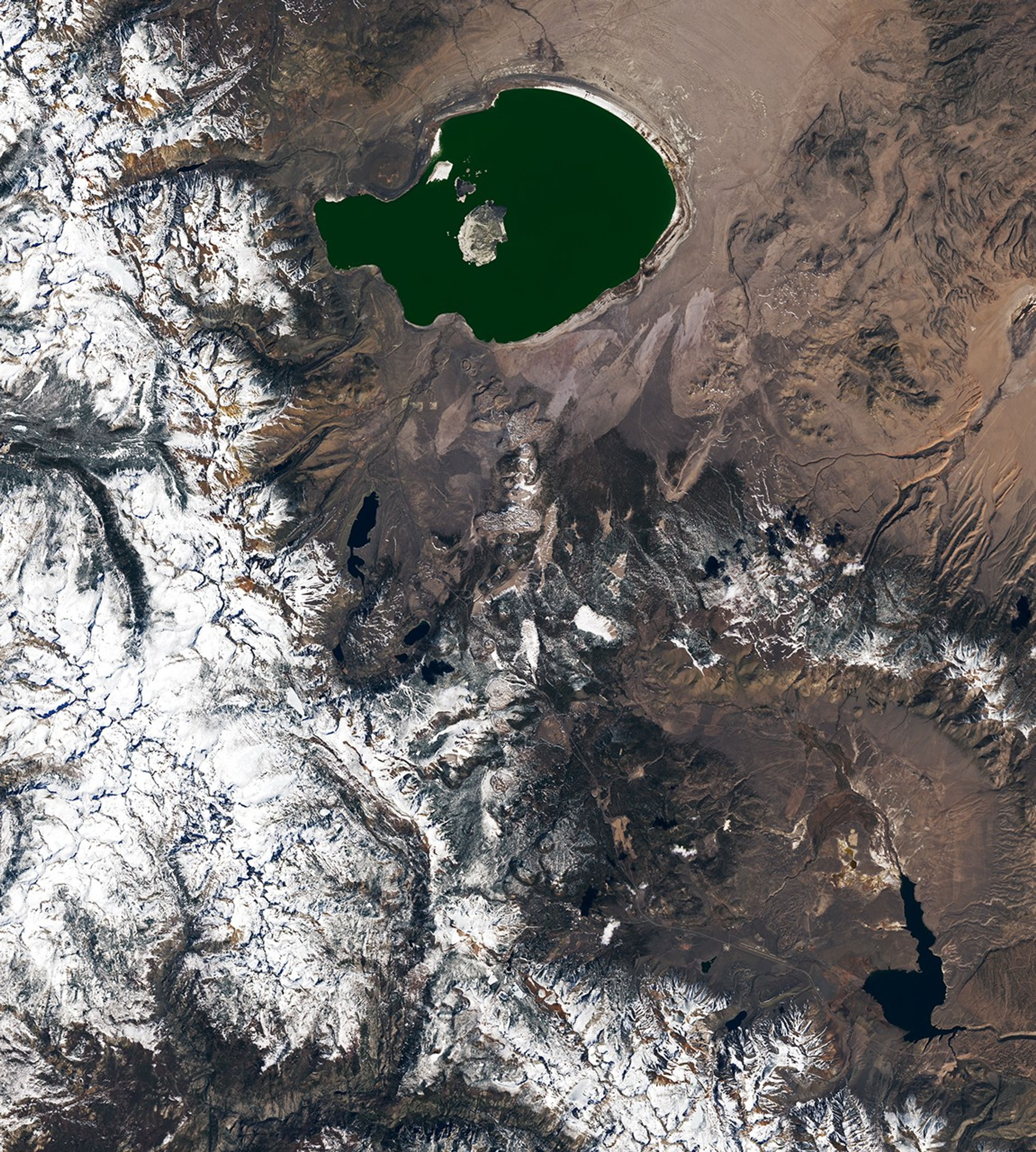
A string of volcanic features between Mono Lake and Mammoth Mountain is visible along the left side of this Landsat image. Known as the Mono-Inyo Craters, this chain of about three dozen lava domes, lava flows, and tephra rings formed within the past 10,000 years. Explosive eruptions in the area date back even further, but evidence of those older events is no longer apparent at the surface.
Among the most recent activity in this chain, explosive eruptions formed Panum Crater near Mono Lake about 700 years ago. A strombolian eruption deposited a ring of pumice, ash, obsidian fragments, and other material around the vent. After that, a lava dome made of pumice and obsidian built up in the center, creating the concentric-circle pattern visible today.
South of the Mono-Inyo Craters, Mammoth Mountain is perhaps best known for its ample skiable terrain, but it has a volcanic side, as well. The mountain is made up of at least 25 overlapping lava domes. Its last magmatic eruptions took place about 57,000 years ago, but steam-driven phreatic eruptions and other unrest have occurred much more recently.
Scientists believe a magma intrusion beneath the mountain in 1989 set off a spate of seismicity and volcanic gas emissions. Venting of carbon dioxide gas has killed trees in the area, and the U.S. Geological Survey continues to monitor the mountain’s CO2 emissions. Researchers have previously worked with NASA airborne remote sensing technology to measure ecosystem responses to elevated volcanic CO2 around Mammoth Mountain. More recent projects have expanded these efforts to other volcanoes and incorporated satellite imagery to detect signs of gas emissions. These methods partly rely on changes observed in vegetation and could aid in earlier warnings of volcanic hazards.
The most dramatic volcanism in the region, however, is far older. A massive eruption 760,000 years ago formed the Long Valley Caldera. This oval-shaped area, measuring 10 by 20 miles (16 by 32 kilometers), is bounded by snowy ridges, with Mammoth Mountain just off its southwest rim. Crowley Lake, a reservoir on the Owens River, drains the area to the southeast.
The caldera was formed during a six-day-long eruption, during which 150 cubic miles (625 cubic kilometers) of material were ejected. (That’s about 20 times the amount that was spewed in the 1912 eruption of Novarupta, the largest on Earth in the 20th century.) As a result, the surface over the magma storage area subsided thousands of feet to create a vast depression. Scientists with NASA’s Goddard Instrument Field Team conducted research in the area in 2023 to better understand how similar massive eruptions on Mars and other planets and moons in our solar system may have altered their environments.
NASA Earth Observatory images by Lauren Dauphin, using Landsat data from the U.S. Geological Survey. Story by Lindsey Doermann.
References & Resources
- Cawse-Nicholson, K., et al. (2018) Ecosystem responses to elevated CO2 using airborne remote sensing at Mammoth Mountain, California. Biogeosciences, 15(24), 7403–7418.
- Global Volcanism Program, Mono-Inyo Craters. Accessed April 7, 2026.
- NASA (2025, May 15) NASA Satellite Images Could Provide Early Volcano Warnings. Accessed April 7, 2026.
- NASA (2023, September) From the Archives: NASA’s Goddard Instrument Field Team at Long Valley Caldera. Accessed April 7, 2026.
- NASA Earth Observatory (2025, February 4) A Network of Dried Lakes. Accessed April 7, 2026.
- Oregon State University, Mono Lake Vol Field. Accessed April 7, 2026.
- U.S. Geological Survey (2023) Long Valley Caldera. Accessed April 7, 2026.
You may also be interested in:
Stay up-to-date with the latest content from NASA as we explore the universe and discover more about our home planet.

The hill-shaped features are a sign of explosive volcanic activity—a rarity on the Red Planet.

The volcano on Russia’s Kamchatka Peninsula continues to erupt after centuries of quiescence.
The volcano in Hawaii is one of the most active in the world, and NASA tech makes it easier for…


Related Posts


Stay Informed With the Latest & Most Important News
Previous Post
Next Post


Advertisement
-
 01Two Black Holes Observed Circling Each Other for the First Time
 -
 02From Polymerization-Enabled Folding and Assembly to Chemical Evolution: Key Processes for Emergence of Functional Polymers in the Origin of Life
 -
 03Astronomy 101: From the Sun and Moon to Wormholes and Warp Drive, Key Theories, Discoveries, and Facts about the Universe (The Adams 101 Series)
 -
 04True Anomaly hires former York Space executive as chief operating officer
 -
 05Φsat-2 begins science phase for AI Earth images
 -
 06Hurricane forecasters are losing 3 key satellites ahead of peak storm season − a meteorologist explains why it matters
 -
 07Binary star systems are complex astronomical objects − a new AI approach could pin down their properties quickly