
Now Reading: AI challenge advances satellite-based disaster mapping
-
01
AI challenge advances satellite-based disaster mapping


29/10/2025
194 views
7 likes
Four teams from different countries have been recognised for their breakthrough work in using artificial intelligence to detect earthquake damage from space, marking the conclusion of a global competition organised by the European Space Agency in collaboration with the International Charter ‘Space and Major Disasters’ – commonly referred to as ‘the Charter’.
The winning teams – TelePIX from the Republic of Korea, Datalayer from Belgium, DisasterM3 from Japan and Thales Services Numériques from France – were honoured recently during a ceremony held at the Charter’s 54th Board Meeting in Strasbourg, as France’s French Space Agency, CNES, took leadership of the Charter for the next six months.
Combining the Charter’s operational experience with ESA Φ-lab’s drive for innovation, the ‘AI for Earthquake Response Challenge’, which is part of the ESA Φ-lab Challenges initiative, brought together 143 participants from 40 countries to explore how far artificial intelligence can go in automating post-disaster damage detection from space.
Competitors trained AI models capable of differentiating between damaged and undamaged buildings using one of the largest Earth observation datasets ever assembled for this purpose – more than 200 high-resolution images of five earthquake events.
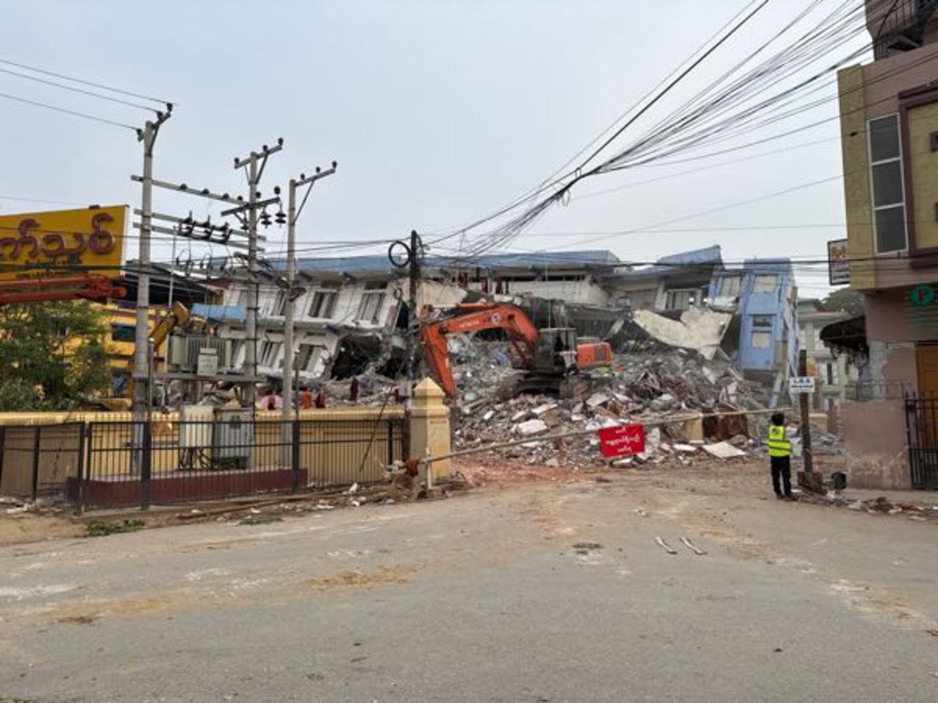
This image above shows the TelePIX team’s winning model prediction over Mandalay, Myanmar, following the earthquake in March 2025. Mandalay was chosen as one of the final test sites in the challenge. Red shapes represent predicted damage. The blue dot indicates the location of the photo also featured below.
Philippe Bally, ESA representative of the Charter, said, “When an earthquake strikes, every minute counts. By accelerating the production of reliable building damage maps from satellite data, these models could one day help rescue teams reach affected communities faster”.
A global collaboration for faster disaster response
Recognising that a single operator or satellite cannot meet the demands of disaster management, ESA and CNES initiated the International Charter Space and Major Disasters in 1999. They were joined by the Canadian Space Agency in 2000. It is now a collaboration between 17 space agencies that provides free satellite imagery to support disaster response worldwide.
Under a six-month rotation system, CNES has now taken over as lead agency, hosting the latest Charter Board meeting and the AI challenge awards ceremony together with ESA.
The AI for Earthquake Response Challenge was designed and implemented by ESA’s Φ-lab together with an industrial team that created the environment, tools and evaluation framework for participants to develop and test their models.
The dataset used in the competition included over 200 high-resolution images from five major earthquakes and 13 sites – a total of 475 GB of data – sourced from the Charter’s operational archives, a global cloud-based platform implemented by ESA and operated by an industrial consortium from Italy and Poland since 2018.
These came from a global virtual constellation of satellites, including Pleiades (CNES/Airbus), WorldView and GeoEye (USGS/Maxar), KOMPSAT-3 (KARI), Global (BlackSky) and Gaofen-2 (CNSA), making it one of the most diverse datasets ever built for AI-driven damage mapping.
Behind the scenes, the effort reflected the Charter’s spirit of international cooperation. The Luxembourg Institute of Science and Technology and ACRI-ST (France) coordinated the competition, providing scientific oversight and ensuring the dataset’s quality and relevance. Terradue (Italy), developer of the ESA Charter Mapper, enabled global access to the data through ESA Φ-lab’s Earth Observation Training Data Lab, giving all teams an equal starting point.
Participants faced challenges similar to real-world emergency operations: multisensor imagery, variable resolutions, complex co-registration, and extreme class imbalance — such as in Mandalay, Myanmar, where only 0.2% of nearly half a million buildings were damaged.
Among the top performers, the European finalists stood out for their cutting-edge approaches. Datalayer leveraged scalable, cloud-based machine learning pipelines to process the massive dataset efficiently, while Thales Services Numériques applied deep-learning and trustworthy-AI techniques from aerospace to pinpoint structural damage with precision.
Next steps
As operator of the Pleiades constellation and current lead agency of the Charter, CNES is now spearheading the post-challenge evaluation to assess how the best-performing AI models can be integrated into operational damage-mapping workflows.
By combining ESA Φ-lab’s spirit of experimentation with the Charter’s humanitarian mission, this initiative has shown how space data and AI can work hand in hand to improve rapid disaster response – a clear example of innovation and international collaboration.


Related Posts
Stay Informed With the Latest & Most Important News
Previous Post
Next Post


Advertisement
-
 01Two Black Holes Observed Circling Each Other for the First Time
 -
 02From Polymerization-Enabled Folding and Assembly to Chemical Evolution: Key Processes for Emergence of Functional Polymers in the Origin of Life
 -
 03Astronomy 101: From the Sun and Moon to Wormholes and Warp Drive, Key Theories, Discoveries, and Facts about the Universe (The Adams 101 Series)
 -
 04True Anomaly hires former York Space executive as chief operating officer
 -
 05Φsat-2 begins science phase for AI Earth images
 -
 06Hurricane forecasters are losing 3 key satellites ahead of peak storm season − a meteorologist explains why it matters
 -
 07Binary star systems are complex astronomical objects − a new AI approach could pin down their properties quickly