
Now Reading: AI Teams Recognized for Innovative Earthquake Damage Assessment Solutions
-
01
AI Teams Recognized for Innovative Earthquake Damage Assessment Solutions


Four innovative teams from various countries have gained recognition for their pioneering efforts in using artificial intelligence to assess earthquake damage from aerial perspectives. This accolade comes as part of a global competition orchestrated by the European Space Agency (ESA) in collaboration with the International Charter on Space and Major Disasters, often referred to simply as ‘the Charter.’
The victorious teams include TelePIX from South Korea, Datalayer from Belgium, DisasterM3 representing Japan, and Thales Services Numériques from France. These groups were celebrated at the Charter’s 54th Board Meeting in Strasbourg, where the French Space Agency, CNES, assumed leadership of the Charter for the upcoming six months. The AI for Earthquake Response Challenge is an initiative within the ESA Φ-lab Challenges framework, merging operational expertise from the Charter with ESA’s innovative spirit. This challenge attracted 143 participants from 40 different nations, all eager to push the boundaries of AI capabilities in automating damage assessments in the aftermath of earthquakes.
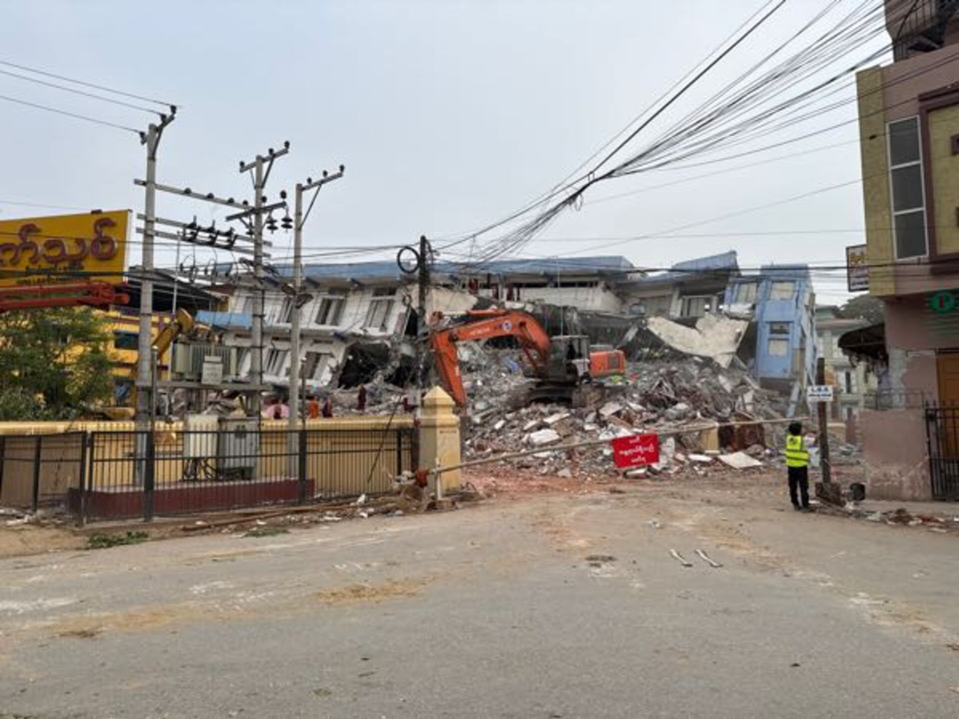
Competitors developed advanced AI models that could distinguish between intact and damaged structures, using a comprehensive dataset comprising over 200 high-resolution images capturing five significant earthquake events. One of these images depicted the TelePIX team’s successful damage estimation in Mandalay, Myanmar, following the March 2025 earthquake. Philippe Bally, an ESA representative from the Charter, emphasized the urgency of rapid responses post-disaster, stating, “When an earthquake strikes, every minute counts. By expediting the creation of accurate damage maps from satellite imagery, these models could significantly enhance how quickly rescue teams are able to reach affected communities.”
The Charter’s inception in 1999 by ESA and CNES recognized the necessity for collaborative efforts in disaster response, establishing a framework that now includes 17 space agencies providing free satellite imagery to aid in emergency situations. Under a rotating six-month leadership system, CNES has now concluded a successful hosting of both the recent Charter Board meeting and the awards ceremony for the AI challenge, alongside ESA’s involvement.
Participants in this AI challenge were confronted with challenges akin to real-world emergencies, such as multisensor imagery issues, varied resolutions, and a complex need for accurate co-registration. These difficulties were exemplified in Mandalay, where only a minuscule fraction—0.2%—of nearly half a million buildings experienced damage from the earthquake. Among the standout finalists were European teams, including Datalayer, which used cloud-based machine-learning strategies for efficient processing of the large dataset, and Thales Services Numériques, which applied deep learning and trusted AI methods from the aerospace sector to accurately identify structural damage.
Looking ahead, CNES, as the operator of the Pleiades satellite constellation and leading agency of the Charter, is initiating a post-challenge evaluation to determine how the winning AI models can be integrated into real-time damage mapping operations. This initiative illustrates a powerful synergy between space technology and artificial intelligence, demonstrating how collaborative efforts can significantly enhance emergency response capabilities in the face of natural disasters.


Related Posts
Stay Informed With the Latest & Most Important News

Advertisement
-
 01Two Black Holes Observed Circling Each Other for the First Time
 -
 02From Polymerization-Enabled Folding and Assembly to Chemical Evolution: Key Processes for Emergence of Functional Polymers in the Origin of Life
 -
 03Astronomy 101: From the Sun and Moon to Wormholes and Warp Drive, Key Theories, Discoveries, and Facts about the Universe (The Adams 101 Series)
 -
 04True Anomaly hires former York Space executive as chief operating officer
 -
 05Φsat-2 begins science phase for AI Earth images
 -
 06Hurricane forecasters are losing 3 key satellites ahead of peak storm season − a meteorologist explains why it matters
 -
 07Binary star systems are complex astronomical objects − a new AI approach could pin down their properties quickly