
Now Reading: BlackSky and Iceye join group creating Earth’s digital twin
-
01
BlackSky and Iceye join group creating Earth’s digital twin

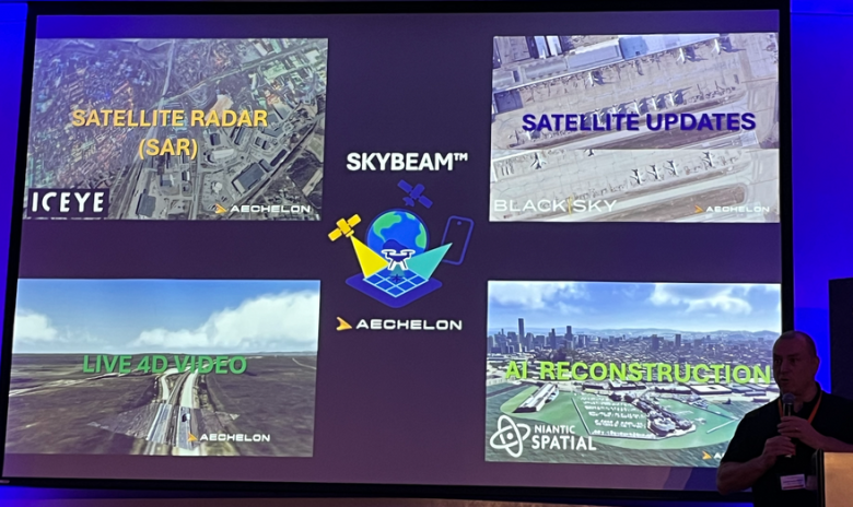
SAN FRANCISCO – Blacksky and Iceye have joined forces with AI-visualization specialists Aechelon Technology and Niantic Spatial to create a digital twin of Earth.
The joint campaign to create a planetary-scale geospatial model that can be frequently refreshed with satellite observations is called Project Orbion.
BlackSky high-resolution visual imagery and Iceye synthetic aperture radar data will feed into Skybeam, Aechelon’s three-dimensional global database.
“Our job is to make the data available for either human users or algorithms,” Nacho Sanz-Pastor, Aechelon co-founder and CEO, said during a Sept. 8 press briefing here. “Machine-learning algorithms are hungry for current data. Frequent satellite observations allow Aechelon to provide those updates.”
BlackSky provides Project Orbion with access to its application programming interface, which allows users to task satellites and pull imagery already acquired along with analytics.
Project Orbion is addressing the challenge of merging various sources of imagery and data in an enterprise environment, Scot Currie, Blacksky vice president of geospatial solutions, told SpaceNews.
Applications ranging from wildfire monitoring to military targeting require background global models with accurate coordinates. Through Project Orbion, the companies are working together to establishing standards for sharing and communicating geospatial data, said Pekka Laurila Iceye co-founder and chief strategy officer.

First Use Case
Niantic and Aechelon also announced that the first test for Project Orbion will be providing 3D scanning and simulation technology to the United States Coast Guard Aviation Training Center.
Aechelon’s flight simulator image generators will integrate Niantic Spatial’s technology to peform tasks like scanning and evaluating helicopter landing zones.
“Aechelon has spent decades creating the most realistic synthetic environments for mission-critical training,” Sanz-Pastor said in a statement. “The challenge has always been keeping pace with changes in the physical world. Niantic Spatial’s technology plays a crucial role in addressing specific use cases, and when combined with our own AI-driven, world-wide multi-sensor baseline, it becomes a powerful solution.”


Related Posts

Stay Informed With the Latest & Most Important News


Advertisement
-
 01Two Black Holes Observed Circling Each Other for the First Time
 -
 02From Polymerization-Enabled Folding and Assembly to Chemical Evolution: Key Processes for Emergence of Functional Polymers in the Origin of Life
 -
 03Astronomy 101: From the Sun and Moon to Wormholes and Warp Drive, Key Theories, Discoveries, and Facts about the Universe (The Adams 101 Series)
 -
 04True Anomaly hires former York Space executive as chief operating officer
 -
 05Φsat-2 begins science phase for AI Earth images
 -
 06Hurricane forecasters are losing 3 key satellites ahead of peak storm season − a meteorologist explains why it matters
 -
 07Binary star systems are complex astronomical objects − a new AI approach could pin down their properties quickly