
Now Reading: Brazil gears up to harness ESA’s Biomass data
-
01
Brazil gears up to harness ESA’s Biomass data

13/11/2025
358 views
13 likes
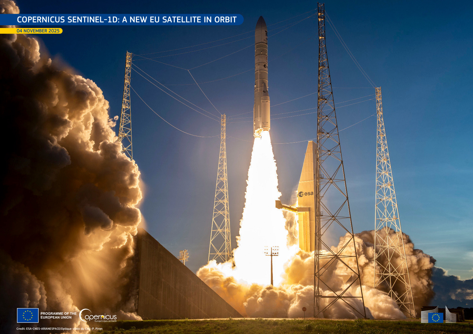
As the COP30 climate conference gets underway in Brazil, the world’s attention is once again drawn to the plight of the Amazon – the planet’s largest and most vital rainforest. With the European Space Agency’s Earth Explorer Biomass satellite now in orbit, ESA is helping Brazil prepare to transform this new mission’s groundbreaking data into actionable knowledge for protecting the rainforest and confronting climate change.
Launched earlier this year, the Biomass mission is designed to unlock novel insights into how forests are changing and their pivotal role in regulating Earth’s carbon cycle.
It is the first satellite to carry a P-band synthetic aperture radar – its signal capable of penetrating forest canopies to measure woody biomass: trunks, branches and stems. These measurements serve as a proxy for carbon storage, the assessment of which is the mission’s primary objective.
The delivery of these novel measurements is, without doubt remarkable, but it is important that users are equipped with the know-how to exploit them to their full potential.
To this end, ESA, the Brazilian National Institute for Space Research (INPE) and the Brazilian Space Agency (AEB) recently joined forces in Belém to assess how best to exploit Biomass’ data.
ESA’s Head of Green Solutions Division, Inge Jonckheere, said, “We’re working to bridge the gap between available satellite data and their practical application in Brazil’s national monitoring efforts, including reporting to international climate frameworks.
“Collaborating closely with our Brazilian partners is essential to ensure that Biomass and other satellite data are fully integrated into their data processing systems, supporting the creation of local, national and regional data products.”
ESA’s Biomass Processor Development Manager, Muriel Pinheiro, noted, “Biomass is the first P-band synthetic aperture radar mission in space, and its data are expected to bring unprecedented insight into forest structure.
“Preparing the Brazilian forestry community for using all the Biomass data products is fundamental, not only to ensure the early uptake of the data, but also to promote independent validation, which is fully aligned to the mission’s open-science oriented strategy.”
Alessandra Gomes from INPE, added, “The INPE–ESA collaboration will allow scientists to evaluate how the ESA Biomass mission can provide new and unprecedented insights into global forest carbon dynamics, especially in the Amazon where cloud cover and dense canopy conditions make monitoring particularly challenging.”


Thanks to the long wavelength of P-band, the radar signal, depending on the polarisation, emitted by the Biomass satellite penetrates the whole forest layer and the signal is scattered back by the individual elements of the forest canopy.
In this way, the measured signal carries information about the forest structure and can be used to infer parameters such as forest biomass and forest height.
A note on the images
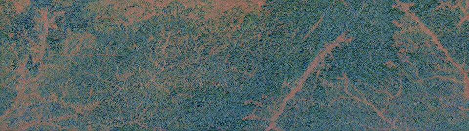
The first image, within the text above, is a map for reference and a strip displaying Biomass data which depicts forest height in a section of rainforest that stretches from northern Brazil to Suriname. This capture also includes a corner of the Tumucumaque Mountains National Park.
Then the two side-by-side images above reveal the forest at different heights. The image on the left shows the forest floor, while the image on the right captures the canopy about 30 metres above the ground.
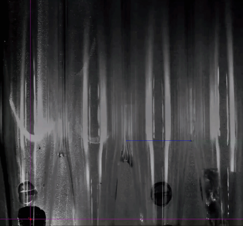
The vertical profile below is a section of forest in the Tumucumaque Mountains National Park, deep in the Amazon rainforest – it offers a glimpse into how forest structure varies across the landscape.
Stefano Tebaldini, Associate Professor at the Politecnico di Milano and who leads the science for Biomass, said, “The Biomass satellite carries a fully polarimetric synthetic aperture radar, meaning it can transmit and receive signals in two orthogonal linear polarisations – horizontal and vertical.
“Each polarisation channel provides different types of information about the forest. But to capture details such as forest height and the structure beneath the canopy, the satellite must pass over the same area multiple times – a technique known as synthetic aperture radar interferometry. Biomass is also the first radar mission in space to include a dedicated tomographic phase, allowing us to build vertical cross-sections of forested regions.
“In short, interpreting and applying the eventual data – Biomass is still in its commissioning phase – is a complex process, but ESA is helping to make sure that users can fully harness this information for science and environmental management.”
It’s important to note that the Biomass satellite is still in its commissioning phase, so these data are not yet suitable for scientific use. However, with ESA’s guidance, examples like these are already helping Brazil’s scientific community prepare for the wealth of information the mission will soon deliver.
Meanwhile, at COP30, ESA’s Head of Actionable Climate Information Section, Clement Albergel, said, “Policymakers from nations around the globe are here assessing progress under the Paris Agreement.
“ESA’s role, in this respect, is to provide transparent and reliable data that enables countries to track their progress and strengthen national climate action – our main effort here is carried out through our Climate Change Initiative, to which the Biomass mission will contribute once it is fully commissioned.
“However, the value of efforts made to help nations use specific data for their own needs cannot be underestimated, particularly when it comes to assessing the health of forests and how they are being altered, which will be tackled as part of the overall Earth Action element of ESA’s FutureEO programme.”


Related Posts

Stay Informed With the Latest & Most Important News
Previous Post
Next Post

Advertisement
-
 01Two Black Holes Observed Circling Each Other for the First Time
 -
 02From Polymerization-Enabled Folding and Assembly to Chemical Evolution: Key Processes for Emergence of Functional Polymers in the Origin of Life
 -
 03Astronomy 101: From the Sun and Moon to Wormholes and Warp Drive, Key Theories, Discoveries, and Facts about the Universe (The Adams 101 Series)
 -
 04True Anomaly hires former York Space executive as chief operating officer
 -
 05Φsat-2 begins science phase for AI Earth images
 -
 06Hurricane forecasters are losing 3 key satellites ahead of peak storm season − a meteorologist explains why it matters
 -
 07Binary star systems are complex astronomical objects − a new AI approach could pin down their properties quickly