
Now Reading: Central Brazil Cerrado
1
-
01
Central Brazil Cerrado


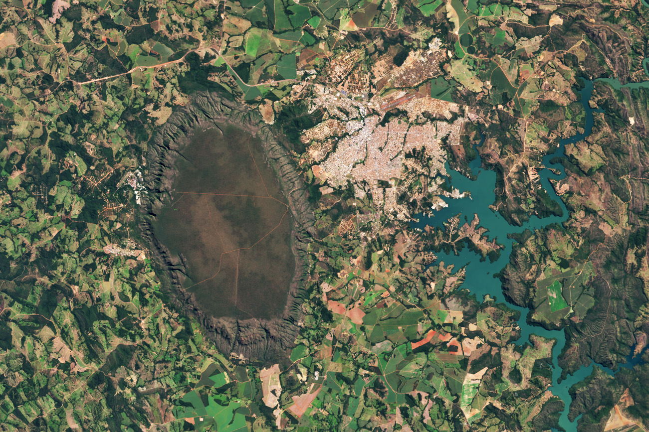
Amid a patchwork of fields, towns, and winding rivers and roads in central Brazil stands a monolithic oval-shaped plateau. This conspicuous feature, the Serra de Caldas (also known as the Caldas Novas dome and Caldas Ridge), is perched about 300 meters (1,000 feet) above the surrounding landscape in the state of Goiás.
NASA/Wanmei Liang; Landsat data: USGS
On May 19, 2025, Landsat 9 captured this image of the Serra de Caldas in the state of Goiás, Brazil. The oval plateau is covered by a biologically rich savanna and grassland ecosystem called Cerrado. The Cerrado covers about one-fifth of Brazil’s land area and represents the second-largest biome in South America behind the Amazon. These lands are home to thousands of plant, bird, reptile, and mammal species, many of which are found nowhere else on the planet.
Learn more about this area sometimes referred to as the “cradle of waters.”
Text credit: Lindsey Doermann
Image credit: NASA/Wanmei Liang; Landsat data: USGS


Related Posts

Stay Informed With the Latest & Most Important News
[mc4wp_form id=314]
Previous Post
Next Post


Advertisement
Loading Next Post...
Popular Now
-
 01Two Black Holes Observed Circling Each Other for the First Time
 -
 02From Polymerization-Enabled Folding and Assembly to Chemical Evolution: Key Processes for Emergence of Functional Polymers in the Origin of Life
 -
 03Astronomy 101: From the Sun and Moon to Wormholes and Warp Drive, Key Theories, Discoveries, and Facts about the Universe (The Adams 101 Series)
 -
 04True Anomaly hires former York Space executive as chief operating officer
 -
 05Φsat-2 begins science phase for AI Earth images
 -
 06Hurricane forecasters are losing 3 key satellites ahead of peak storm season − a meteorologist explains why it matters
 -
 07Binary star systems are complex astronomical objects − a new AI approach could pin down their properties quickly
Scroll to Top