
Now Reading: CSDA Program Announces Eight New Data Agreements
-
01
CSDA Program Announces Eight New Data Agreements


CSDA Program Announces Eight New Data Agreements

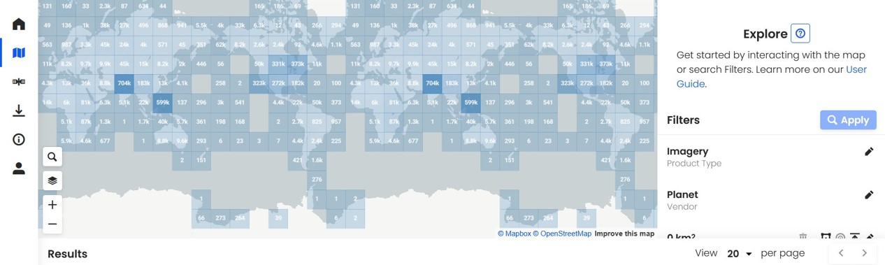
NASA’s Commercial Satellite Data Acquisition (CSDA) Program announced eight new agreements with seven of its commercial partners— Airbus Defense and Space GEO Inc (Airbus U.S.), Capella Space Corporation, ICEYE US, MDA Space, Planet Labs, Umbra, and Vantor (formerly Maxar)—to give users more access to near‑global multispectral and synthetic aperture radar (SAR) data. With these agreements, the CSDA program further advances its mission to acquire data from commercial providers that supports NASA’s Earth science research and applications, and expands the quality, coverage, and range of Earth observation data NASA offers to the scientific community.
“These new agreements will provide users with a range of high-quality multispectral and SAR data that can be used in a variety of applications from environmental monitoring to surface deformation,” said CSDA Project Manager Dana Ostrenga. “In addition, they exemplify the CSDA Program’s commitment to acquiring data that enhances and supports the agency’s application and research objectives.”
New Near-Global, Multispectral Imagery
In support of NASA programs and stakeholders, the CSDA program enacted three agreements with Planet, Airbus, and Vantor (formerly Maxar) to provide near‑global multispectral and pan‑sharpened electro‑optical satellite imagery of nearly all global land and coastal surfaces. This imagery has a spatial resolution of approximately 30 centimeters, 1 meters, and up to 10 meters (depending on the product) and is suitable for applications including environmental monitoring, agriculture, and urban applications. Data products will include Top of Atmosphere radiances and surface reflectance across the visible and near‑infrared spectrum.
New SAR Data
In response to NASA’s and users’ needs for SAR data, and following rigorous technical and programmatic evaluation, CSDA executed five agreements for high‑resolution SAR imagery, including tasked Spotlight, StripMap, Scan, Wide/Extended Spotlight, and Long‑Dwell modes, with Capella, ICEYE, MDA, Umbra, and Airbus. These SAR capabilities provide all‑weather, day‑night imaging that complements the electro‑optical agreements and enhances NASA’s ability to monitor dynamic processes such as flooding, land deformation, sea‑ice motion, and infrastructure impacts. Further, under these agreements, each commercial partner will provide specific data requirements consistent with their respective sensor capabilities and performance, as well as tasking and archive access.
Increased Access and User Eligibility
The data acquired under these agreements will be made available to authorized commercial satellite data users in accordance with the CSDA Program’s End User License Agreements (EULAs). EULAs generally pertain to NASA‑funded investigators and designated collaborators and outline established mechanisms for accessing CSDA data, such as the CSDA Satellite Data Explorer (SDX) and related portals. Users can contact the CSDA Program at csda-support@nasa.gov to obtain additional information about user agreements, detailed product specifications, and procedures for requesting and accessing these commercial datasets for their research and application activities.
About the CSDA Program
NASA’s Earth Science Division (ESD) established the CSDA Program to identify, evaluate, and acquire data from commercial providers that to support NASA’s Earth science research and applications. NASA recognizes the potential of commercial satellite constellations to advance Earth System Science and applications for societal benefit and believes commercially acquired data may also can augment the Earth observations acquired by NASA, and other U.S. government agencies, and NASA’s international partners.
All data from CSDA contract-awarded vendors are evaluated by the investigator-led CSDA project teams that assess the value of adding a vendor’s data to CSDA’s data holdings based on their quality and how they might benefit in the context of NASA Earth science research and applications. To learn more about the program, its commercial partners, data evaluation process, and more, visit the CSDA website.


Related Posts

Stay Informed With the Latest & Most Important News
Previous Post
Next Post


Advertisement
-
 01Two Black Holes Observed Circling Each Other for the First Time
 -
 02From Polymerization-Enabled Folding and Assembly to Chemical Evolution: Key Processes for Emergence of Functional Polymers in the Origin of Life
 -
 03Astronomy 101: From the Sun and Moon to Wormholes and Warp Drive, Key Theories, Discoveries, and Facts about the Universe (The Adams 101 Series)
 -
 04True Anomaly hires former York Space executive as chief operating officer
 -
 05Φsat-2 begins science phase for AI Earth images
 -
 06Hurricane forecasters are losing 3 key satellites ahead of peak storm season − a meteorologist explains why it matters
 -
 07Binary star systems are complex astronomical objects − a new AI approach could pin down their properties quickly