
Now Reading: Earth from Space: French Guiana
-
01
Earth from Space: French Guiana

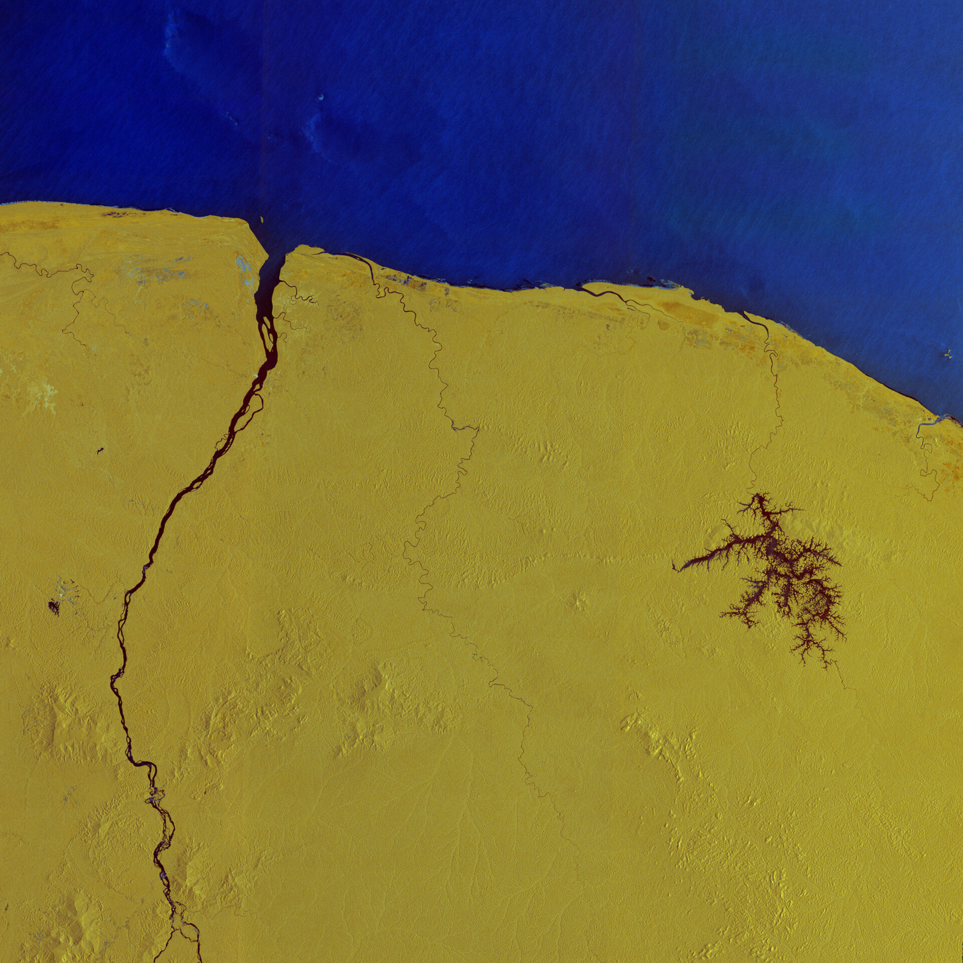

Copernicus Sentinel-1 captured this radar image over French Guiana – home to Europe’s Spaceport in Kourou, where ESA’s Biomass mission is being prepared for liftoff on 29 April onboard a Vega-C rocket.
Zoom in to explore this image at its full resolution or click on the circles to learn more.
This false-colour view shows part of the northeast coast of South America, stretching from the estuary of the Kourou River in French Guiana in the east, to Suriname, west of the Maroni River. The latter is visible as a dark line, snaking its way across the image and marking the border between the two countries.
The colours in this image come from the combination of two polarisations from the Copernicus Sentinel-1 mission, which have been assigned a colour and converted into a single composite. This processing technique helps to distinguish different types of surface, thereby providing detailed information.
Here, water is clearly reflected in dark shades of blue. Distinct wave patterns can be seen in the Atlantic Ocean since the radar signal is highly sensitive to changes in the roughness on the water: calm waters appear darker, while rough seas appear brighter.
The dark, branching waterways of the Petit Saut Reservoir stand out in the centre-right of the image. The water body was formed by a hydroelectric dam built on the Sinnamary River. The river can be seen winding its way north to eventually drain into the Atlantic Ocean.
Most of the land is shown in vibrant shades of yellow, indicating tropical rainforests and other areas of vegetation, where radar signal interacts and bounces from the complex structure of the canopy, including tree trunks, branches and leaves. Built-up areas appear more colourful than the surroundings.
With over 90% of land covered by forest, French Guiana is the territory with the most trees per inhabitant in the world. Since it is an overseas department of France, it is also the only part of the Amazonian forest in the EU.
Northeast of the Petit Saut Reservoir, on the coast between the estuary of the Sinnamary River and the Kourou River, lies Europe’s Spaceport. This is home to the ESA-developed Ariane and Vega rocket families and allows for independent, reliable access to space for Europe.
From here, ESA’s Biomass mission is scheduled to launch on a Vega-C rocket on 29 April.
Once in orbit, this latest Earth Explorer mission will provide vital insights into the health and dynamics of the world’s forests, revealing how they are changing over time and, critically, enhancing our understanding of their role in the global carbon cycle, and hence in the climate system.


Related Posts
Stay Informed With the Latest & Most Important News
Previous Post
Next Post


Advertisement
-
 01Two Black Holes Observed Circling Each Other for the First Time
 -
 02From Polymerization-Enabled Folding and Assembly to Chemical Evolution: Key Processes for Emergence of Functional Polymers in the Origin of Life
 -
 03Astronomy 101: From the Sun and Moon to Wormholes and Warp Drive, Key Theories, Discoveries, and Facts about the Universe (The Adams 101 Series)
 -
 04True Anomaly hires former York Space executive as chief operating officer
 -
 05Φsat-2 begins science phase for AI Earth images
 -
 06Hurricane forecasters are losing 3 key satellites ahead of peak storm season − a meteorologist explains why it matters
 -
 07Binary star systems are complex astronomical objects − a new AI approach could pin down their properties quickly