
Now Reading: Earth from Space: Kilauea lava lake, Hawaii
-
01
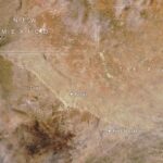
Earth from Space: Kilauea lava lake, Hawaii

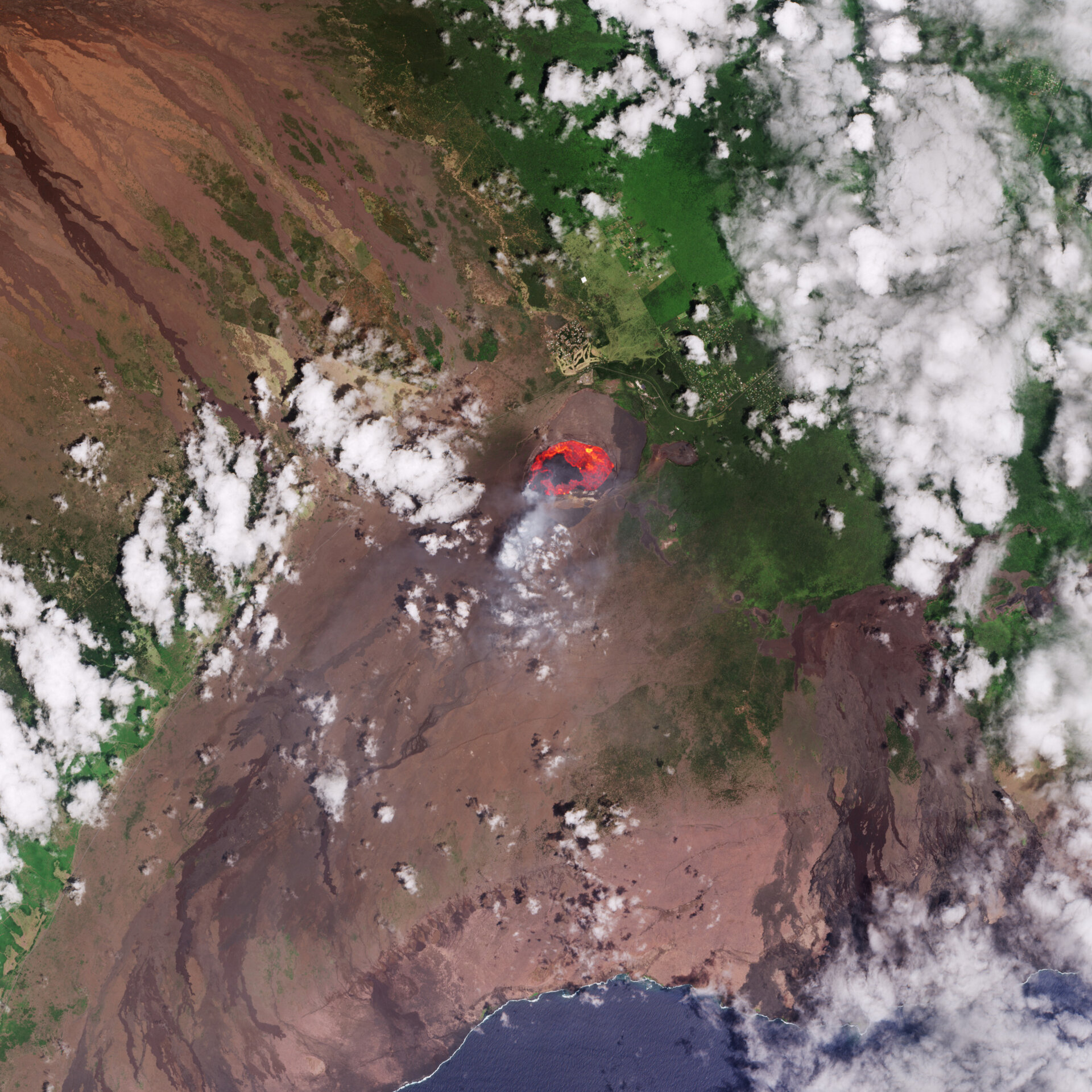

This Copernicus Sentinel-2 image captures an active lava lake on the Kilauea volcano on Hawaii’s Big Island.
Zoom in or click on the circles to explore this image at its full 10 m resolution.
Located in the central Pacific Ocean, Big Island is the southeastern-most island in the US state of Hawaii and, as its name suggests, the largest in the archipelago. Having formed above a magma hotspot in the Pacific plate, Hawaii has some of the world’s largest active volcanoes. One of these is Kilauea on the southeastern side of Big Island.
This Copernicus Sentinel-2 image from 3 September 2025 shows a lava lake approximately 2.5 km in length, inside the main crater of Kilauea. Following an eruptive episode on 2 September, lava fountains reached about 100 m high and lava flowed from multiple vents in the main crater.
Although the image has been processed in natural colour, the mission’s shortwave infrared channels, which detect heat sources, were also used to highlight the fiery lava flowing from the crater in orange and red. Plumes of smoke can also be seen leaking from the crater.
The current eruptive phase began on 23 December 2024 and continued into 2025 with repeated episodes of lava spewing into the air and flowing down the volcano. Signs of older eruptions are visible on the southern flanks of the crater as dark brown flows of solidified lava towards the coast.
Unlike the event pictured here, which was confined within the summit’s crater and posed little threat to the nearby communities, the eruption that began in May 2018 was one of the most destructive in Kilauea’s recorded history. It destroyed more than 600 homes and produced about 320 000 Olympic-sized swimming pools’ worth of lava that reshaped the landscape.
As we see in the image, the volcanic rock creates a rugged terrain, which contrasts with the surrounding lush vegetation and fields. In particular, light green and yellow areas north of the main crater correspond to human settlements, roads and plantations.
Big Island, like the other Hawaiian islands, has tropical forests from the combination of fertile volcanic soil and heavy rainfall. The clouds, visible throughout the image, form when the Pacific trade winds blow across the mountains in the middle of the ocean.
Satellite missions such as Copernicus Sentinel-2 are an excellent way to monitor volcanic eruptions, as they can image smoke plumes, lava flows, mudslides and ground fissures and can be used to help assess damage.


Related Posts

Stay Informed With the Latest & Most Important News


Advertisement
-
 01Two Black Holes Observed Circling Each Other for the First Time
 -
 02From Polymerization-Enabled Folding and Assembly to Chemical Evolution: Key Processes for Emergence of Functional Polymers in the Origin of Life
 -
 03Astronomy 101: From the Sun and Moon to Wormholes and Warp Drive, Key Theories, Discoveries, and Facts about the Universe (The Adams 101 Series)
 -
 04True Anomaly hires former York Space executive as chief operating officer
 -
 05Φsat-2 begins science phase for AI Earth images
 -
 06Hurricane forecasters are losing 3 key satellites ahead of peak storm season − a meteorologist explains why it matters
 -
 07Binary star systems are complex astronomical objects − a new AI approach could pin down their properties quickly