
Now Reading: Earth from Space: Maritime highways in the Øresund Strait
-
01
Earth from Space: Maritime highways in the Øresund Strait

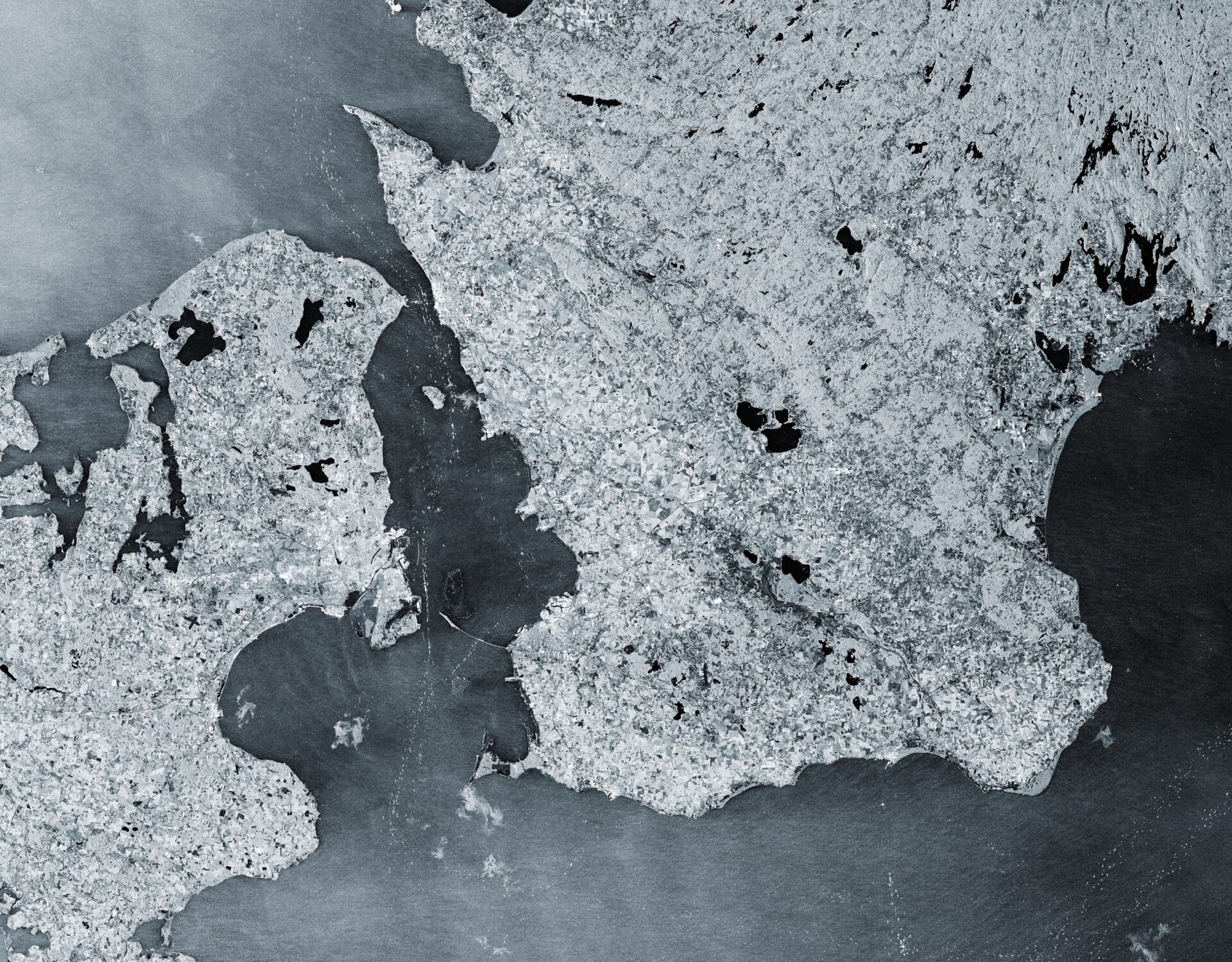

This image from the Copernicus Sentinel-1 mission shows us the maritime traffic passing through theØresund Strait in 2025.
Zoom in or click on the circles to explore this image at its full 10 m resolution.
The 118-km-long Øresund Strait (also known as the Sound) separates Denmark to the west from Sweden to the east and links the Baltic Sea to the North Sea, which makes it one of the busiest waterways in the world.
Sentinel-1 satellites carry radar instruments to provide an all-weather, day-and-night supply of imagery of Earth’s surface, making it ideal to monitor ship traffic. Here, more than 50 radar images over the same area, acquired every six days throughout 2025, have been compressed into a single image.
Radar data are interpreted by studying the intensity of the backscattered radar signal. Areas where the radar signal is reflected away from the satellite, such as water bodies and smooth surfaces, appear darker, while areas where the signal is reflected back to the satellite, such as urban areas, metal objects or hard infrastructure, appear lighter.
In this image, ships appear as bright, sparkly dots in the dark waters of the strait. The routes of marine traffic are clear to see in the channel with the main shipping lanes highlighted by the concentration of ships.
Most notable are the high-density clusters of bright points near the ports of Copenhagen and Malmö. These are ‘waiting areas’ where ships remain stationary for longer periods, increasing the probability of being captured across multiple satellite passes.
Copenhagen, Denmark’s capital, is near the centre of the strait on the eastern side of the islands of Zealand and Amager. Copenhagen Airport is visible as a cross-shaped, black structure on the eastern side of Amager.
The bright, elongated feature in the strait in front of the airport is the artificial island of Peberholm. It is part of the Øresund Bridge, a combined bridge-tunnel across the strait that connects Copenhagen with the city of Malmö on the Swedish coast. Peberholm serves as a crossover point between the bridge, visible as a thin, white line to its eastern end, and the Drogden underwater tunnel on the Danish side.
The geometric patterns of dots, visible south of the bridge about 10 km off the Swedish coast, are the turbines of the Lillgrund Wind Farm, which is Sweden’s largest offshore wind farm. Another group of wind turbines can be seen off the coast of Copenhagen harbour: the 20 turbines of the Middelgrunden offshore wind farm appear as a 3.4-km-long string of pearls in the dark water of the strait.


Related Posts


Stay Informed With the Latest & Most Important News
Previous Post
Next Post


Advertisement
-
 01Two Black Holes Observed Circling Each Other for the First Time
 -
 02From Polymerization-Enabled Folding and Assembly to Chemical Evolution: Key Processes for Emergence of Functional Polymers in the Origin of Life
 -
 03Astronomy 101: From the Sun and Moon to Wormholes and Warp Drive, Key Theories, Discoveries, and Facts about the Universe (The Adams 101 Series)
 -
 04True Anomaly hires former York Space executive as chief operating officer
 -
 05Φsat-2 begins science phase for AI Earth images
 -
 06Hurricane forecasters are losing 3 key satellites ahead of peak storm season − a meteorologist explains why it matters
 -
 07Binary star systems are complex astronomical objects − a new AI approach could pin down their properties quickly