
Now Reading: Earth from Space: World’s biggest iceberg
-
01
Earth from Space: World’s biggest iceberg

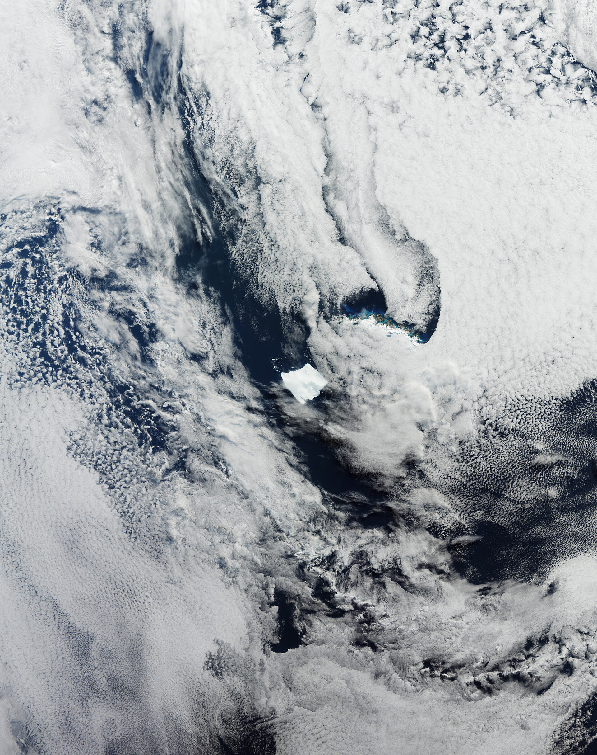

The Ocean and Land Colour Instrument on Copernicus Sentinel-3 captured this image of Earth’s biggest iceberg, A23a, on 5 April 2025.
Zoom in to explore this image at its full resolution.
The ice mass is currently lodged on the seabed 73 km from the remote island of South Georgia, which can be seen just poking out from beneath the cloud cover.
Although the size of the island is not clearly visible in this image, it is only marginally bigger than the iceberg. The A23a is estimated to cover an area of 3460 sq km – twice the size of Greater London in the UK. In comparison, the island of South Georgia is 3528 sq km.
An image of the berg was also featured by ESA in December 2023 when it was dislodged from the ocean floor and was pushed by currents away from the Antarctic. It initially calved from Filchner Ice Shelf in 1986. Since then, it has travelled more than 2000 km.
A23a has started to disintegrate and many smaller blocks of ice are visible in the dark blue ocean, particularly to the north of the berg. The disintegration is typical of icebergs that reach this far north and is caused by the warmer sea temperatures and weather conditions.
South Georgia is a mountainous island 170 km in length, with a central ridge that reaches a height of 2935 m. It lies in the South Atlantic Ocean, about 1400 km east of the Falkland Islands (Las Malvinas) and northeast of the tip of the Antarctic Peninsula.
It is the largest of the South Georgia and South Sandwich archipelago, a British overseas territory and is home to a range of biodiversity, including penguins and seals, as well a British Antarctic Survey research station.


Related Posts

Stay Informed With the Latest & Most Important News
Previous Post
Next Post

Advertisement
-
 01Two Black Holes Observed Circling Each Other for the First Time
 -
 02From Polymerization-Enabled Folding and Assembly to Chemical Evolution: Key Processes for Emergence of Functional Polymers in the Origin of Life
 -
 03Astronomy 101: From the Sun and Moon to Wormholes and Warp Drive, Key Theories, Discoveries, and Facts about the Universe (The Adams 101 Series)
 -
 04True Anomaly hires former York Space executive as chief operating officer
 -
 05Φsat-2 begins science phase for AI Earth images
 -
 06Hurricane forecasters are losing 3 key satellites ahead of peak storm season − a meteorologist explains why it matters
 -
 07Binary star systems are complex astronomical objects − a new AI approach could pin down their properties quickly