
Now Reading: EarthCARE lifts the clouds on climate models
-
01
EarthCARE lifts the clouds on climate models


03/12/2025
377 views
14 likes
True to its promise, the European Space Agency’s EarthCARE satellite is now being used to calculate directly how clouds and aerosols influence Earth’s energy balance – the all-important balance that regulates our climate. In doing so, EarthCARE is poised to sharpen the accuracy of climate models, the very tools that guide global climate policy and action.
Although clouds and aerosols are currently known to have an overall cooling effect, their interactions with incoming energy from the Sun and with thermal radiation that Earth emits back out to space are highly complex, and not fully understood.
As greenhouse gas emissions continue to warm the planet, it remains unclear how clouds will respond. A reduction in cloud cover, for instance, would allow more sunlight to reach the surface, amplifying warming.
Aerosols add yet another layer of uncertainty. They tend to cool the climate by reflecting sunlight and also by making clouds more reflective and longer-lived. But recent shifts – from sharp declines in industrial pollution to huge plumes of wildfire smoke – could significantly alter their overriding role in the climate system. However, the full impact of these changes remains unclear.
Predictions of future climate change rely on computer models that simulate the atmosphere, oceans and the wider Earth system under different scenarios. Climate model representations of clouds, aerosols and their interactions with sunlight and infrared radiation are based on simplified mathematical descriptions of their behaviour, often relying on measurements and numerous assumptions.
Launched in May 2024, EarthCARE – an ESA Earth Explorer mission developed in partnership with the Japan Aerospace Exploration Agency (JAXA) – carries four specialised instruments designed to take different measurements of clouds and aerosols simultaneously.
This synergy is key: by combining these observations, EarthCARE can work out important cloud properties such as how much water they contain and the size of the cloud particles. This, in turn, can be used to improve how these aspects are represented in climate models, paving the way for more reliable climate projections.
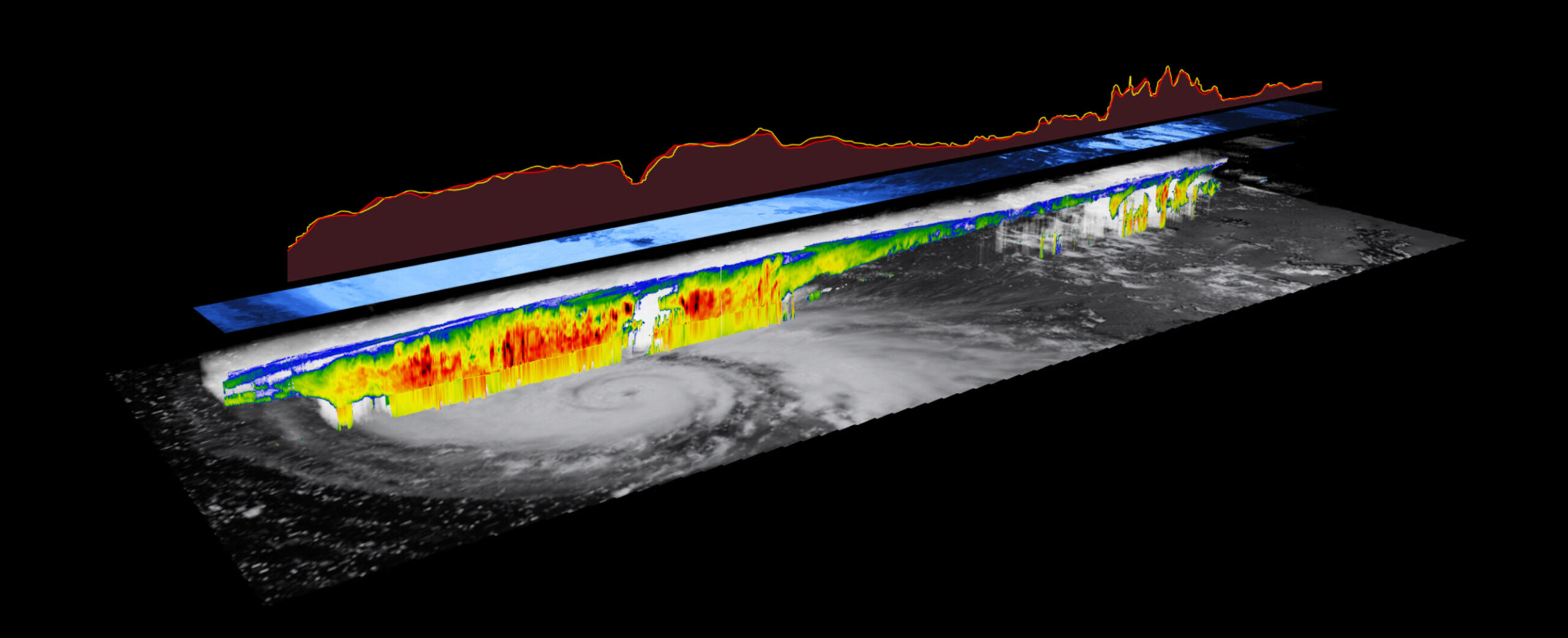
The animation below presents a sequence of measurements acquired by EarthCARE over Typhoon Ragasa near the Philippines on 20 September 2025, and illustrates ‘radiative closure’ – one of the mission’s key science goals.
The animation first shows how data from EarthCARE’s cloud profiling radar (CPR), atmospheric lidar (ATLID) and multispectral imager (MSI) are combined to derive vertical slices of properties such as cloud and precipitation water content – that is, water in liquid droplets, ice crystals, rain and snow.
Next, information from MSI’s horizontal imagery is used to extrapolate these vertical cloud profiles across the satellite’s track. By identifying pixels with similar optical properties, the system reconstructs the 3D cloud structure.
Using a computational technique known as radiative transfer modelling, this 3D cloud representation is then used to estimate how incoming sunlight is scattered by cloud particles and Earth’s surface, and consequently how much is reflected back to space.
In the animation, this calculated reflected sunlight appears as the blue-shaded shaded horizontal strip and the red line at the top. This is then compared against independent measurements by EarthCARE’s broadband radiometer (BBR), shown by the yellow line at the top, and the agreement is very good.
Robin Hogan, Principal Scientist at the European Centre for Medium-Range Weather Forecasts (ECMWF), said, “We always expected EarthCARE to deliver on its promise, and these results surely demonstrate that it is doing just that.
“Here we see that EarthCARE is able to work out the detailed properties of clouds and aerosols in the atmosphere, and then immediately check that their projected radiative impacts are consistent with solar and infrared energy flows that are also measured by the satellite. This onboard validation of the data from EarthCARE gives extra confidence in the use of the cloud and aerosol properties for testing and improving climate models.”
As an ESA Earth Explorer, EarthCARE is a research mission, but its data are so reliable that they are also going to be used in daily weather forecasts.
Prof. Hogan explained, “At ECMWF we want to assimilate EarthCARE data into our model in real time: by providing a more accurate picture of cloud locations at the start of a forecast, these data will help the model better capture the evolution of weather systems and deliver more reliable predictions.
“Work to integrate EarthCARE’s data streams is progressing rapidly, and the system is on track to become operational very soon. EarthCARE is therefore not only advancing our understanding of our climate, but also delivering immediate benefits for day-to-day forecasting and climate services.”
ESA’s EarthCARE Mission Manager, Bjoern Frommknecht, added, “On 1 December, during the second joint workshop bringing together European, Canadian and Japanese scientists, the complete suite of EarthCARE Level-2 data products was released to the public for the first time. This follows the release of Level-1 data back in January and some of the Level-2 data in March.
“This new release includes the much-anticipated ‘radiative closure’ product, which directly links measurements of clouds and aerosols with observed energy fluxes – offering an unprecedented window into the processes that shape Earth’s climate.”
Making the full dataset openly available means that researchers worldwide can now begin testing new hypotheses, validating climate and weather models, and exploring how recent atmospheric changes –from wildfire smoke to shifts in pollution – are affecting the planet’s energy balance. It also strengthens international cooperation: by sharing tools and expertise across agencies and continents, the EarthCARE community is accelerating scientific progress and expanding the mission’s reach.
The data are available from the EarthCARE Online Dissemination Service.
Also read news from JAXA: All observation data now publicly available.


Related Posts

Stay Informed With the Latest & Most Important News
Previous Post
Next Post


Advertisement
-
 01Two Black Holes Observed Circling Each Other for the First Time
 -
 02From Polymerization-Enabled Folding and Assembly to Chemical Evolution: Key Processes for Emergence of Functional Polymers in the Origin of Life
 -
 03Astronomy 101: From the Sun and Moon to Wormholes and Warp Drive, Key Theories, Discoveries, and Facts about the Universe (The Adams 101 Series)
 -
 04True Anomaly hires former York Space executive as chief operating officer
 -
 05Φsat-2 begins science phase for AI Earth images
 -
 06Hurricane forecasters are losing 3 key satellites ahead of peak storm season − a meteorologist explains why it matters
 -
 07Binary star systems are complex astronomical objects − a new AI approach could pin down their properties quickly