
Now Reading: Entrepreneurs Challenge Winner PRISM is Using AI to Enable Insights from Geospatial Data
-
01
Entrepreneurs Challenge Winner PRISM is Using AI to Enable Insights from Geospatial Data

4 min read
Entrepreneurs Challenge Winner PRISM is Using AI to Enable Insights from Geospatial Data

NASA sponsored Entrepreneurs Challenge events in 2020, 2021, and 2023 to invite small business start-ups to showcase innovative ideas and technologies with the potential to advance the agency’s science goals. To potentially leverage external funding sources for the development of innovative technologies of interest to NASA, SMD involved the venture capital community in Entrepreneurs Challenge events. Challenge winners were awarded prize money, and in 2023 the total Entrepreneurs Challenge prize value was $1M. Numerous challenge winners have subsequently refined their products and/or received funding from NASA and external sources (e.g., other government agencies or the venture capital community) to further develop their technologies.
One 2023 Entrepreneurs Challenge winner, PRISM Intelligence (formerly known as Pegasus Intelligence and Space), is using artificial intelligence (AI) and other advances in computer vision to create a new platform that could provide geospatial insights to a broad community.
Every day, vast amounts of remote sensing data are collected through satellites, drones, and aerial imagery, but for most businesses and individuals, accessing and extracting meaningful insights from this data is nearly impossible.
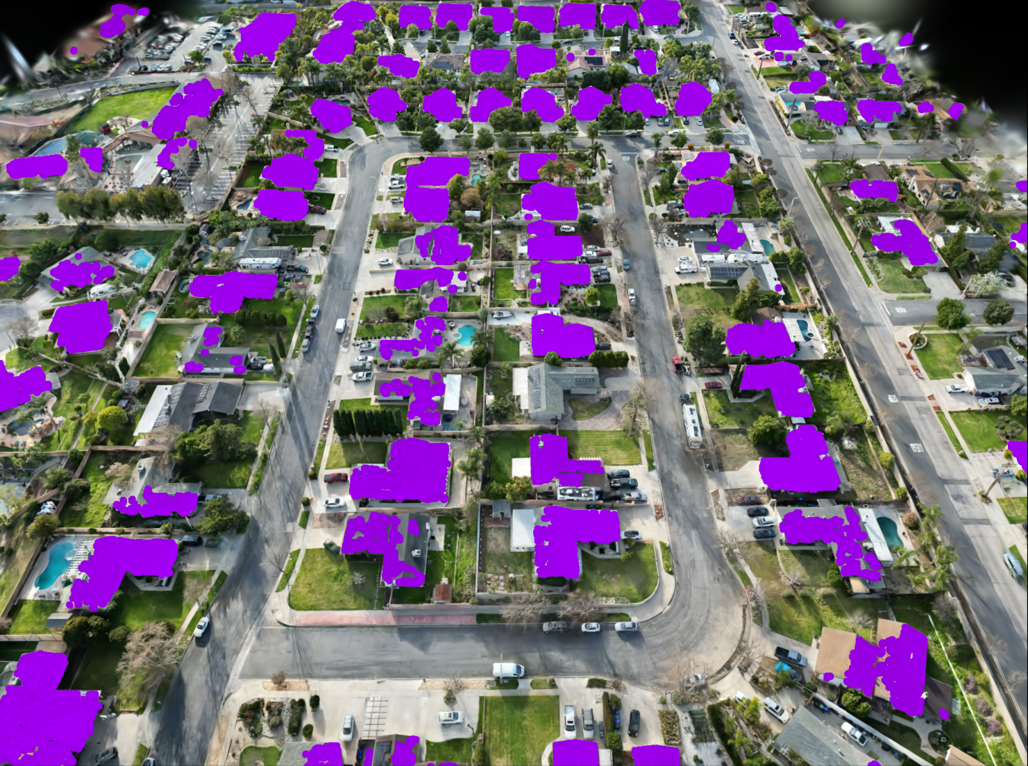
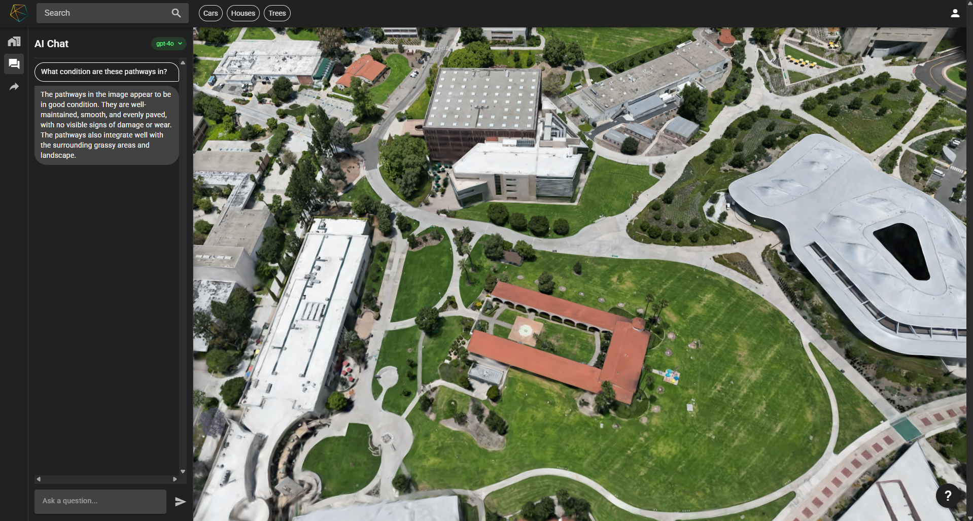
The company’s product—Personal Real-time Insight from Spatial Maps, a.k.a. PRISM—is transforming geospatial data into an easy-to-navigate, queryable world. By leveraging 3D computer vision, geospatial analytics, and AI-driven insights, PRISM creates photorealistic, up-to-date digital environments that anyone can interact with. Users can simply log in and ask natural-language questions to instantly retrieve insights—no advanced Geographic Information System (GIS) expertise is required.
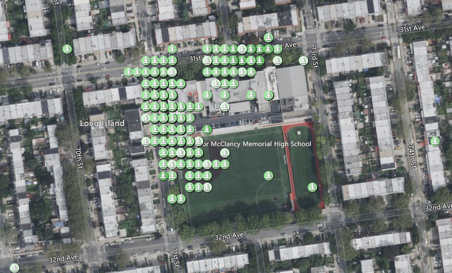
For example, a pool cleaner looking for business could use PRISM to search for all residential pools in a five-mile radius. A gardener could identify overgrown trees in a community. City officials could search for potholes in their jurisdiction to prioritize repairs, enhance public safety, and mitigate liability risks. This broad level of accessibility brings geospatial intelligence out of the hands of a few and into everyday decision making.
The core of PRISM’s platform uses radiance fields to convert raw 2D imagery into high-fidelity, dynamic 3D visualizations. These models are then enhanced with AI-powered segmentation, which autonomously identifies and labels objects in the environment—such as roads, vehicles, buildings, and natural features—allowing for seamless search and analysis. The integration of machine learning enables PRISM to refine its reconstructions continuously, improving precision with each dataset. This advanced processing ensures that the platform remains scalable, efficient, and adaptable to various data sources, making it possible to produce large-scale, real-time digital twins of the physical world.
“It’s great being able to push the state of the art in this relatively new domain of radiance fields, evolving it from research to applications that can impact common tasks. From large sets of images, PRISM creates detailed 3D captures that embed more information than the source pictures.” — Maximum Wilder-Smith, Chief Technology Officer, PRISM Intelligence
Currently the PRISM platform uses proprietary data gathered from aerial imagery over selected areas. PRISM then generates high-resolution digital twins of cities in select regions. The team is aiming to eventually expand the platform to use NASA Earth science data and commercial data, which will enable high-resolution data capture over larger areas, significantly increasing efficiency, coverage, and update frequency. PRISM aims to use the detailed multiband imagery that NASA provides and the high-frequency data that commercial companies provide to make geospatial intelligence more accessible by providing fast, reliable, and up-to-date insights that can be used across multiple industries.
What sets PRISM apart is its focus on usability. While traditional GIS platforms require specialized training to use, PRISM eliminates these barriers by allowing users to interact with geospatial data through a frictionless, conversational interface.
The impact of this technology could extend across multiple industries. Professionals in the insurance and appraisal industries have informed the company how the ability to generate precise, 3D assessments of properties could streamline risk evaluations, reduce costs, and improve accuracy—replacing outdated or manual site visits. Similarly, local governments have indicated they could potentially use PRISM to better manage infrastructure, track zoning compliance, and allocate resources based on real-time, high-resolution urban insights. Additionally, scientists could use the consistent updates and layers of three-dimensional data that PRISM can provide to better understand changes to ecosystems and vegetation.
As PRISM moves forward, the team’s focus remains on scaling its capabilities and expanding its applications. Currently, the team is working to enhance the technical performance of the platform while also adding data sources to enable coverage of more regions. Future iterations will further improve automation of data processing, increasing the speed and efficiency of real-time 3D reconstructions. The team’s goal is to expand access to geospatial insights, ensuring that anyone—from city planners to business owners—can make informed decisions using the best possible data.

Share
Details
Related Terms


Related Posts


Stay Informed With the Latest & Most Important News
Previous Post
Next Post


Advertisement
-
 01Two Black Holes Observed Circling Each Other for the First Time
 -
 02From Polymerization-Enabled Folding and Assembly to Chemical Evolution: Key Processes for Emergence of Functional Polymers in the Origin of Life
 -
 03Astronomy 101: From the Sun and Moon to Wormholes and Warp Drive, Key Theories, Discoveries, and Facts about the Universe (The Adams 101 Series)
 -
 04True Anomaly hires former York Space executive as chief operating officer
 -
 05Φsat-2 begins science phase for AI Earth images
 -
 06Hurricane forecasters are losing 3 key satellites ahead of peak storm season − a meteorologist explains why it matters
 -
 07Binary star systems are complex astronomical objects − a new AI approach could pin down their properties quickly