
Now Reading: Erie Canal seen from space, is now 200 years old | Space photo of the day for Oct 1. 2025
-
01
Erie Canal seen from space, is now 200 years old | Space photo of the day for Oct 1. 2025

Erie Canal seen from space, is now 200 years old | Space photo of the day for Oct 1. 2025
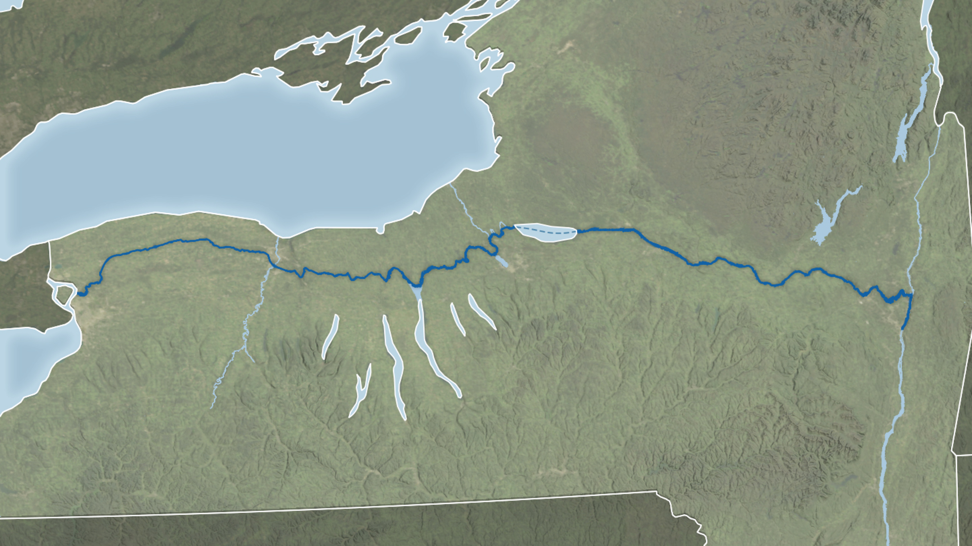
2025 marks the bicentennial of the Erie Canal, and NASA’s Earth Observatory commemorated the milestone with a satellite-based image tracing the canal’s historic route across New York State.
What is it?
According to NASA’s Earth Observatory, the image combines shoreline data with the “Blue Marble: Next Generation” base map, which is constructed from imagery collected by NASA’s Moderate Resolution Imaging Spectroradiometer (MODIS) aboard Earth-scanning satellites.
Where is it?
This image was taken from orbit above the Erie Canal.

Why is it amazing?
The Erie Canal was one of the defining projects of early America. Construction was completed in 1825, despite the lack of trained engineers at the time. Builders, often self-taught and guided by trial and error, created what was dubbed the “Erie School of Engineering.” They devised solutions to challenges such as the Niagara Escarpment near Lockport, where 83 locks were needed to manage the elevation changes, and they built aqueducts to carry the canal over rivers and streams.
Beyond its engineering feats, the canal spurred growth and settlement along its route. Cities like Rochester, Syracuse and Buffalo flourished, transforming from small towns into the industrial and commercial hubs they are today.
Want to learn more?
You can read more about NASA’s Earth-scanning satellites and waterways across our globe.


Related Posts

Stay Informed With the Latest & Most Important News
Previous Post
Next Post


Advertisement
-
 01Two Black Holes Observed Circling Each Other for the First Time
 -
 02From Polymerization-Enabled Folding and Assembly to Chemical Evolution: Key Processes for Emergence of Functional Polymers in the Origin of Life
 -
 03Astronomy 101: From the Sun and Moon to Wormholes and Warp Drive, Key Theories, Discoveries, and Facts about the Universe (The Adams 101 Series)
 -
 04True Anomaly hires former York Space executive as chief operating officer
 -
 05Φsat-2 begins science phase for AI Earth images
 -
 06Hurricane forecasters are losing 3 key satellites ahead of peak storm season − a meteorologist explains why it matters
 -
 07Binary star systems are complex astronomical objects − a new AI approach could pin down their properties quickly