
Now Reading: Habitable Planet Orbital Assay: Biomass Mission Views Our Home World
-
01
Habitable Planet Orbital Assay: Biomass Mission Views Our Home World


Today, at the Living Planet Symposium, ESA revealed the first stunning images from its groundbreaking Biomass satellite mission – marking a major leap forward in our ability to understand how Earth’s forests are changing and exactly how they contribute to the global carbon cycle. But these inaugural glimpses go beyond forests. Remarkably, the satellite is already showing potential to unlock new insights into some of Earth’s most extreme environments.
Biomass – an Earth Explorer research mission developed within ESA’s FutureEO programme – was launch less than two months ago. This new mission is, therefore, still in the process of being commissioned, but its first set of images are stunning none the less.
ESA’s Biomass Project Manager, Michael Fehringer, commented, “As is routine, we’re still in the commissioning phase, fine-tuning the satellite to ensure it delivers the highest quality data for scientists to accurately determine how much carbon is stored in the world’s forests.
“Biomass is equipped with novel space technology, so we’ve been closely monitoring its performance in orbit, and we’re very pleased to report that everything is functioning smoothly and its first images are nothing short of spectacular – and they’re only a mere glimpse of what is still to come.”
Biomass is the first satellite to carry a P-band synthetic aperture radar, its signal capable of penetrating forest canopies to measure woody biomass – trunks, branches and stems. These measurements serve as a proxy for carbon storage, the assessment of which is the mission’s primary objective.
While it settles into its life in orbit, ESA’s pioneering Biomass mission is already returning data. The satellite, its instrument and systems are still being calibrated so these first data cannot yet be used to quantify carbon or support scientific advances, but they do show that Biomass is well on track to achieving its goals.
ESA’s Director of Earth Observation Programmes, Simonetta Cheli, said, “Looking at these first images, it’s clear to see that our Earth Explorer Biomass satellite is set to deliver on its promise.
“We fully expect that this new mission will provide a groundbreaking leap in our ability to understand Earth’s forests – combining cutting-edge radar technology with the scientific excellence that will unlock vital insights into carbon storage, climate change, and the health of our planet’s precious forest ecosystems.”
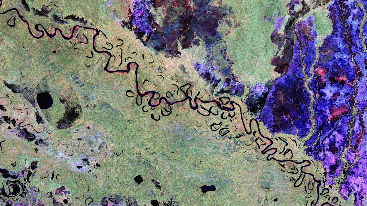
Biomass’ first image showcased here above features part of Bolivia. Bolivia has experienced significant deforestation, ranking among the highest globally for primary forest loss. Although there are complex reasons at play, this is primarily driven by forest clearance for agricultural expansion.
This vibrant image was created using the radar instrument’s different polarisation channels, with each colour revealing distinct characteristics of the landscape. For instance, green hues mainly represent rainforest, red hues forested floodplains and wetlands, and blue–purple is indicative of grasslands, while black areas are rivers and lakes.
In the Amazon Basin, some rivers run wild – unhindered by dams, they are free to meander, but some more dramatically than others. The image captures one such wanderer, the Beni River, which flows from the Andes Mountains across the Bolivian lowlands northeast towards Brazil.
The true strength of the Biomass mission lies not in identifying features from a single image, but in its unique sampling technique and ability to combine multiple observations of the same area to reveal forest height and biomass. This enables scientists to accurately quantify forest carbon stocks and better understand the role of tropical forests in the global carbon cycle.
Additional imagery, ESA
Astrobiology,


Related Posts
Stay Informed With the Latest & Most Important News


Advertisement
-
 01Two Black Holes Observed Circling Each Other for the First Time
 -
 02From Polymerization-Enabled Folding and Assembly to Chemical Evolution: Key Processes for Emergence of Functional Polymers in the Origin of Life
 -
 03Astronomy 101: From the Sun and Moon to Wormholes and Warp Drive, Key Theories, Discoveries, and Facts about the Universe (The Adams 101 Series)
 -
 04True Anomaly hires former York Space executive as chief operating officer
 -
 05Φsat-2 begins science phase for AI Earth images
 -
 06Hurricane forecasters are losing 3 key satellites ahead of peak storm season − a meteorologist explains why it matters
 -
 07Binary star systems are complex astronomical objects − a new AI approach could pin down their properties quickly