
Now Reading: ‘It probably will start a precedent’: Why satellite company’s withholding of Iran imagery has this expert worried
-
01
‘It probably will start a precedent’: Why satellite company’s withholding of Iran imagery has this expert worried

‘It probably will start a precedent’: Why satellite company’s withholding of Iran imagery has this expert worried
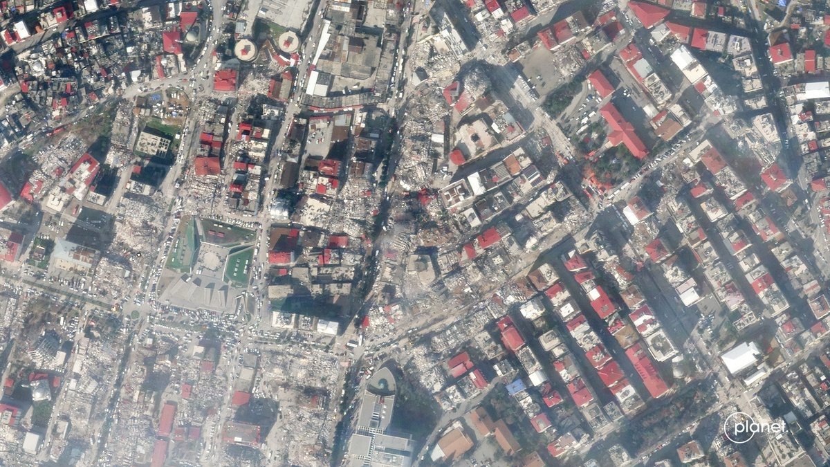
The Earth-observation company Planet Labs is withholding its satellite imagery of Iran indefinitely.
In response to a request from the U.S. government, Planet Labs made a decision not to share photos of Iran as well as the larger conflict region in the Middle East indefinitely, the California company shared in an April 5 statement emailed to customers. The decision follows a 14-day delay in imagery of the Middle East that the company initiated last month in an effort to prevent attacks on the U.S. and its allies, according to Reuters.

“It seems that it’s a way to impact the American public’s ability to understand what’s happening as opposed to having an impact on the battlefield,” Victoria Samson, chief director of space security and stability for the nonprofit Secure World Foundation, told Space.com.
Planet Labs operates a large fleet of satellites in low Earth orbit that capture images of our planet, which are then sold to government agencies, or companiesWhile the U.S. government is one of the company’s largest customers, it is not the only one, and Planet Labs has a history of working internationally. The company even describes itself as being a “mission-led public benefit corporation whose founding purpose is to use space to help life on Earth.”
Indeed, satellite imagery like that captured by Planet Labs is used for a variety of purposes, not just defense planning.
“It’s unfortunate given the extent that their work is used, not just by militaries but by other actors trying to follow refugee flow and seeing where there’s damage, and for agricultural reasons,” Samson said, adding that withholding images sparks concerns from a public safety perspective.
In addition to the many non-military purposes that satellite imagery serves, it also allows the public to see with their own eyes what is happening in a given region and the true extent of damages inflicted during wartime, as well as the consequences of other actions.
Samson cited one specific instance from earlier in the war in which satellite imagery — specifically, photos from Planet Labs — played an important role. In early March, there was initial confusion about the extent of the strikes that took place on an Iranian school. Satellite imagery from Planet Labs revealed the extent of the damage and shed light on how many lives were lost in the attack.
In its history, Planet Labs has previously freely shared important imagery. For instance, the company has released photos that have helped first responders deal with natural disasters, as well as imagery revealing details about Russia’s ongoing invasion of Ukraine.
This is not the first time that satellite imagery has been restricted from public view. For example, photos of sensitive military locations or government facilities are often blurred on applications like Google Maps. However, Samson said, Planet Labs’ decision appears to be the first time that such a large region has been restricted from satellite view.
“It probably will start a precedent that I don’t think will be good for overall transparency,” she said.
Planet Labs also shared in the April 5 statement that it will be holding back all imagery dating back to March 9, and that this withholding will continue until the conflict has ended. There is one small exception to this ban, however. Planet Labs will release images on a case-by-case basis if an urgent need presents itself, the company shared in the statement. These decisions follow the official start of the war, which began on Feb. 28 when the U.S. and Israel attacked Iran.
Planet Labs is among a variety of companies that provide satellite imaging services, and some of the others may be making similar decisions. For example, the companyVantor, formerly known as Maxar Intelligence, told Space.com that it has put “controls in place over parts of the Middle East,” though the company added that these controls “were not put in place in response to a specific U.S. government request.” At this time, it is unclear what other companies are also restricting access to satellite imagery.
Space.com reached out to Planet Labs for comment, but the company did not respond before the publication deadline.


Related Posts


Stay Informed With the Latest & Most Important News
Previous Post
Next Post
Previous Post
Next Post


Advertisement
-
 01Two Black Holes Observed Circling Each Other for the First Time
 -
 02From Polymerization-Enabled Folding and Assembly to Chemical Evolution: Key Processes for Emergence of Functional Polymers in the Origin of Life
 -
 03Astronomy 101: From the Sun and Moon to Wormholes and Warp Drive, Key Theories, Discoveries, and Facts about the Universe (The Adams 101 Series)
 -
 04True Anomaly hires former York Space executive as chief operating officer
 -
 05Φsat-2 begins science phase for AI Earth images
 -
 06Hurricane forecasters are losing 3 key satellites ahead of peak storm season − a meteorologist explains why it matters
 -
 07Binary star systems are complex astronomical objects − a new AI approach could pin down their properties quickly