
Now Reading: Maxar and Ecopia roll out AI-powered Earth mapping system
-
01
Maxar and Ecopia roll out AI-powered Earth mapping system

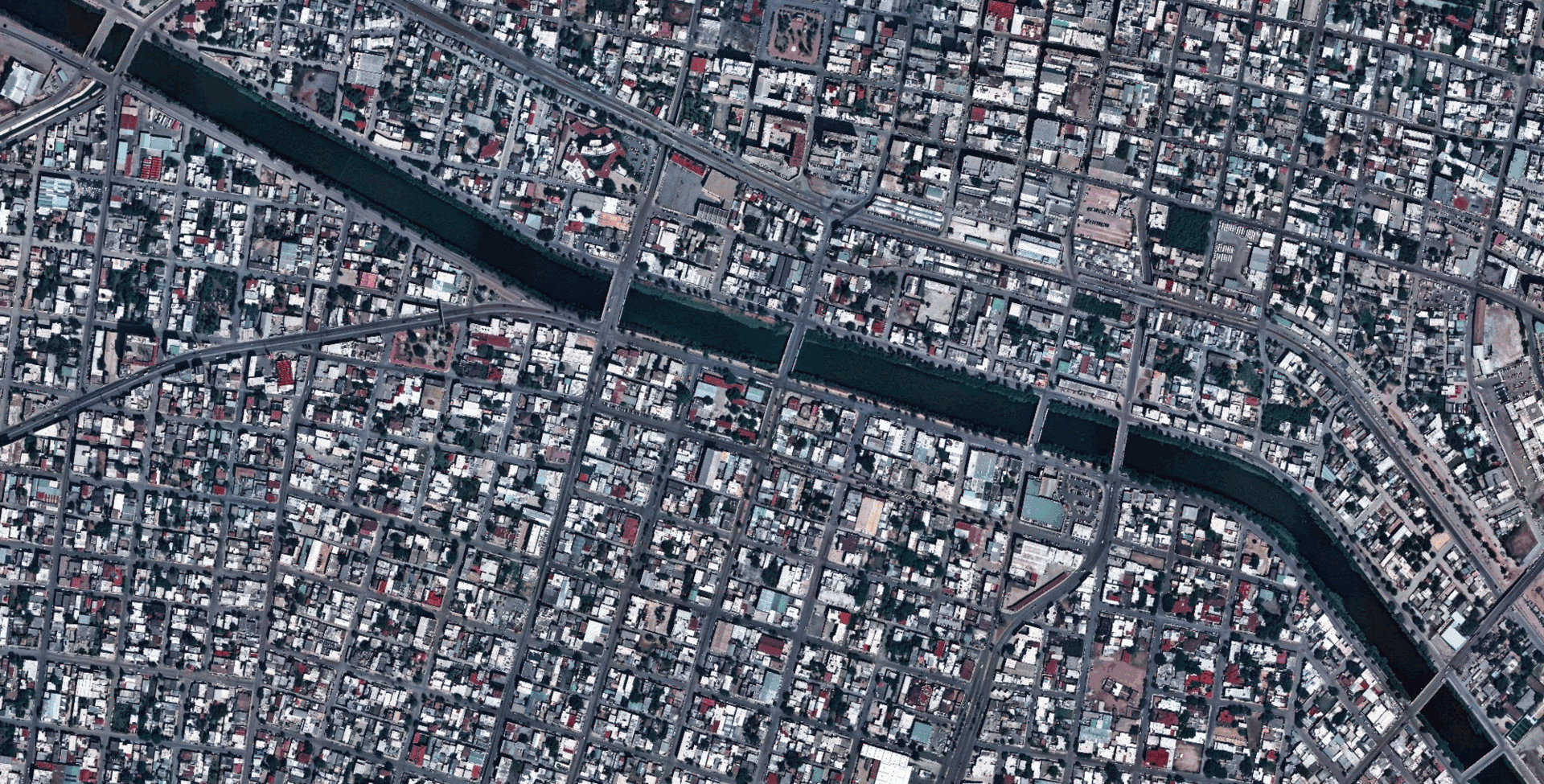

WASHINGTON — Maxar Intelligence released a new mapping product developed with Ecopia AI that converts satellite imagery into detailed 2D and 3D maps. The product, called Vivid Features, combines Maxar’s satellite imagery archive with Ecopia’s artificial intelligence software to automatically identify and outline buildings, roads, vegetation, water bodies and other features.
Vector maps, unlike traditional raster images, represent the world using geometric shapes — points, lines and polygons — instead of pixels. They store location data as mathematical equations, making them more precise and easier to update. That precision is critical for everything from urban planning to defense operations, but keeping vector datasets current has historically been labor-intensive and slow.
Maxar and Ecopia say the partnership is focused on reducing those delays and inconsistencies.
“Mapmakers are stuck with laborious processes to update vector maps that reflect the ground truth, a process that takes days and misses critical developments,” Maxar said in a Sept. 17 release. “Maxar and Ecopia’s new Vivid Features product changes that completely by delivering precisely aligned vector maps that mapping systems and AI models can trust. Vivid Features maintains 3-meter accuracy across time, so when your AI flags a new building or road, you know it’s there.”
AI automation
Ecopia, founded in 2013, specializes in using artificial intelligence to extract features from high-resolution satellite imagery and build what it calls a “digital twin of the Earth.” Its machine learning models can pick out and outline buildings, roads, vegetation, waterways and more with minimal human intervention.
By combining those algorithms with Maxar’s global satellite archive, the companies say they can automatically generate vector maps that update as the real world changes.
“Vivid Features, powered by Ecopia, solves one of the most persistent challenges in digital mapping — the time-consuming process of producing consistent vector map data of every place on Earth,” said Peter Wilczynski, Maxar’s chief product officer. “Together, we’ve created a product that eliminates the thousands of hours customers typically spend manually creating and aligning vectors, providing a dynamic basemap suite that maintains fidelity as the world changes.”
Commercial and defense demand
The potential use cases include government agencies that rely on accurate geospatial data for emergency planning, disaster response and infrastructure management. Commercial players use it for risk modeling in insurance, planning telecom networks and tracking population growth.
For military users, the companies said, vector maps could serve as a backbone of geospatial intelligence feeding into mission planning and decision making.
“Gaining an up-to-date, three-dimensional understanding of our planet and how it is changing is one of the most complex challenges our customers face,” said Jon Lipinski, Ecopia’s president and co-founder. “While millions of square kilometers of satellite images are captured each day, many organizations struggle to develop corresponding 3D vector maps and keep them current to reflect real-world change. This partnership with Maxar will enable unprecedented access to up-to-date 3D vector maps across the globe.”
Maxar, based in Westminster, Colorado, operates a fleet of high-resolution imaging satellites and has long provided imagery to both commercial customers and the U.S. government. Toronto-based Ecopia AI has carved out a niche by applying artificial intelligence and machine learning to geospatial challenges and has already partnered with major players in the sector.


Related Posts


Stay Informed With the Latest & Most Important News
Previous Post
Next Post
Previous Post
Next Post


Advertisement
-
 01Two Black Holes Observed Circling Each Other for the First Time
 -
 02From Polymerization-Enabled Folding and Assembly to Chemical Evolution: Key Processes for Emergence of Functional Polymers in the Origin of Life
 -
 03Astronomy 101: From the Sun and Moon to Wormholes and Warp Drive, Key Theories, Discoveries, and Facts about the Universe (The Adams 101 Series)
 -
 04True Anomaly hires former York Space executive as chief operating officer
 -
 05Φsat-2 begins science phase for AI Earth images
 -
 06Hurricane forecasters are losing 3 key satellites ahead of peak storm season − a meteorologist explains why it matters
 -
 07Binary star systems are complex astronomical objects − a new AI approach could pin down their properties quickly