
Now Reading: NASA Data Helps Maine Oyster Farmers Choose Where to Grow
-
01
NASA Data Helps Maine Oyster Farmers Choose Where to Grow


NASA Data Helps Maine Oyster Farmers Choose Where to Grow
NASA/Ross Walter and Allison Nussbaum
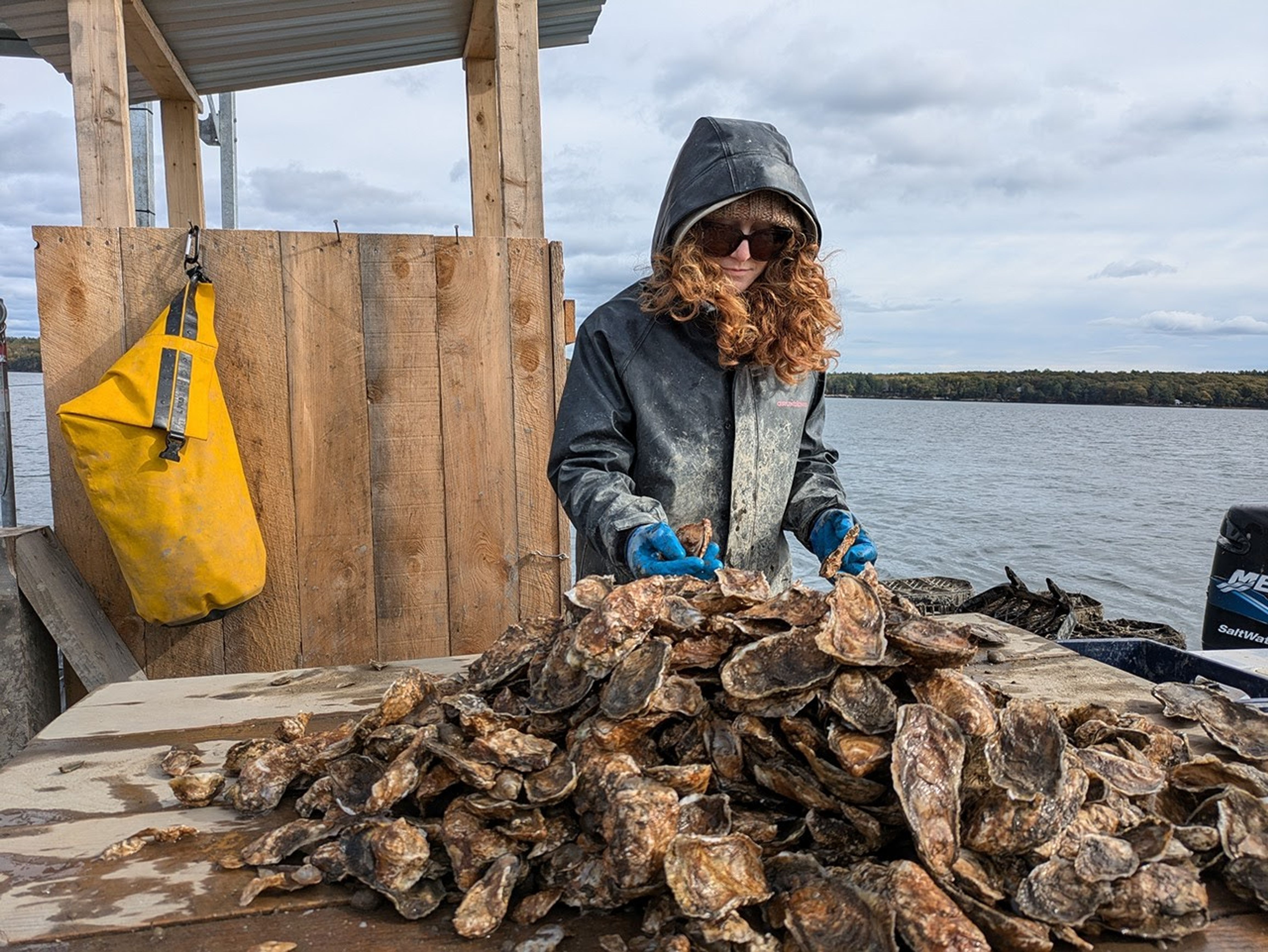
When oyster farmer Luke Saindon went looking for a place to grow shellfish in Maine, he knew that picking the wrong patch of water could sink the farm before it began. So Saindon did something oyster farmers couldn’t have done a generation ago: He used NASA satellite data to view the coastline from space.
“Starting a farm is a big venture,” said Saindon, the director for The World Is Your Oyster farm in Wiscasset, Maine. “If you choose the wrong spot, you can blow through a lot of money without ever bringing oysters to market.”
NASA satellites had been passing over these waters for years, recording temperatures and other conditions. Using a site-selection tool created by University of Maine researchers, Saindon examined satellite maps showing where water temperatures and food levels might be best for growing oysters. The maps pointed him toward a wide, shallow bay near his home. Four years later, the farm is still there — and the oysters are thriving.

Saindon believes that using the satellite data to select his oyster farm site resulted in faster-than-average growth rates.
“This is an example of how NASA’s Earth science program supports our nation,” said Chris Neigh, the Landsat 8 and 9 project scientist at NASA’s Goddard Space Flight Center in Greenbelt, Maryland. “We collect global data, but its value grows when it’s used locally to help communities work smarter and make their livelihoods more sustainable.”
From orbit to oyster
That same satellite-based approach is now the foundation of a study published Jan. 15 in the journal Aquaculture. Led by University of Maine scientists Thomas Kiffney and Damian Brady, the research demonstrates how temperature data from Landsat — the joint NASA and U.S. Geological Survey mission — combined with European Sentinel-2 satellite estimates of oyster food availability, namely plankton, can predict how quickly eastern oysters (Crassostrea virginica) reach market size.
The team built a satellite data–driven model of how oysters divide their energy among growth, survival, and reproduction. Feed the model sea surface temperature and satellite estimates of chlorophyll and particulate organic matter — signals of how much plankton and other edible particles are in the water — and it predicts how fast oysters will grow, a big step beyond just spotting good or bad sites for farms.
“By showing where oysters grow faster, the model can help farmers plan ahead,” Kiffney said. “That could mean better decisions about when to seed, when to harvest, and how much product to expect, all of which reduces financial risk.”
That kind of insight is increasingly valuable in Maine, where oyster farming has grown rapidly over the last decade. From 2011 to 2021, the industry’s value increased 78%, rising from about $2.5 million to more than $10 million. As the sector scales up, understanding the finer details of Maine’s coastal waters has become essential — and that’s where NASA satellites come in.
The stakes are considerable. “It takes two to three years of scoping in order to get your permit to grow, and then it can take two years for those oysters to reach market,” Brady said. “So if you’ve chosen the wrong site, you’re four years in the hole right off the bat.”
Sharper eyes on coast
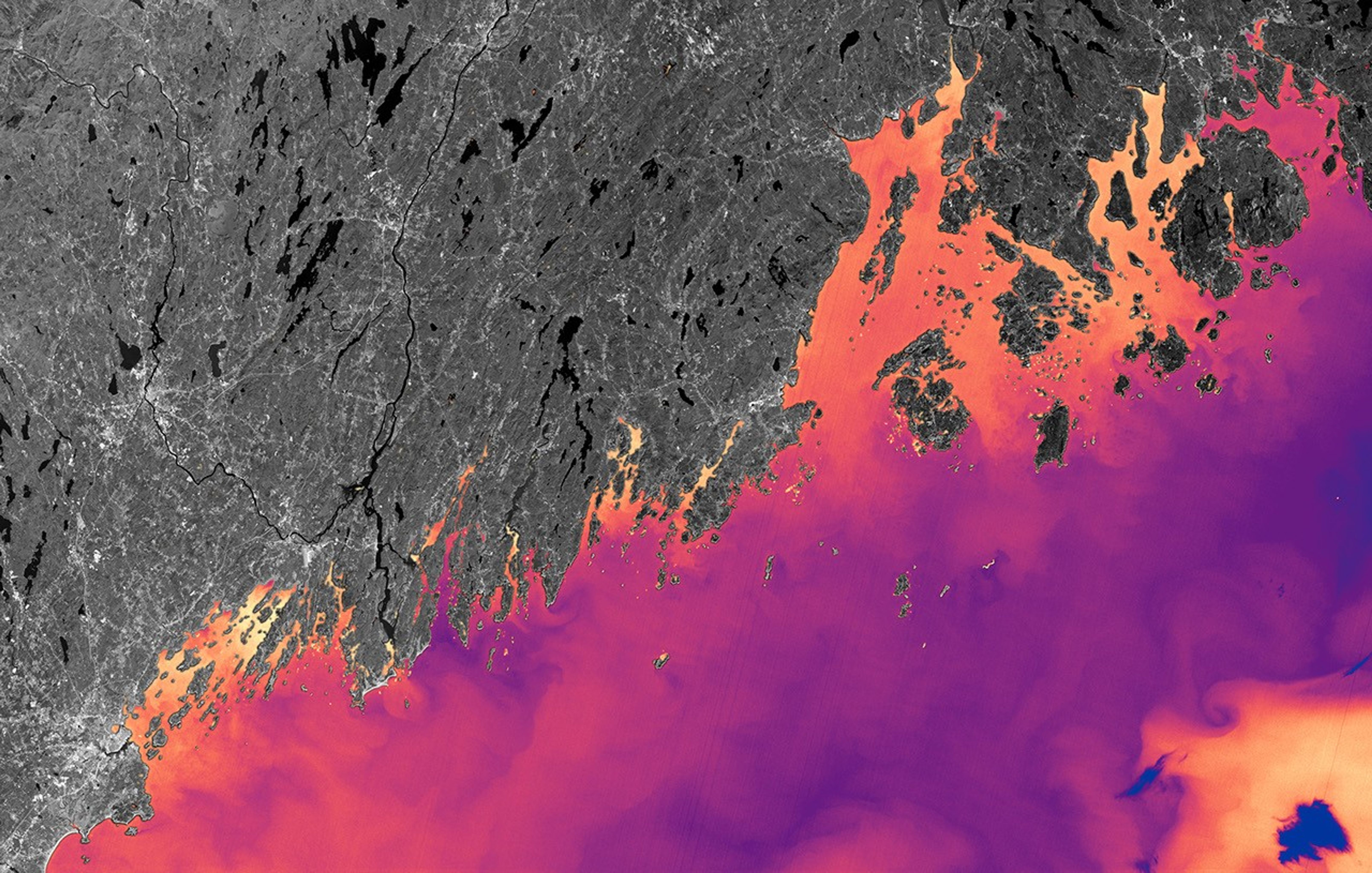
Maine’s coastline measures about 3,400 miles (5,500 kilometers) if you follow the tide line. It is a coast of drowned valleys and glacier-scoured granite. Water depth, temperature, and circulation can shift dramatically within a few miles. This complexity makes oyster site selection notoriously difficult, and some satellites that see the coast in broad strokes miss the small, patchy places where oysters live.
“What makes Landsat so powerful for aquaculture is its ability to see finer-scale patterns along the coast,” where farmers put oyster cages in the water, Neigh said.
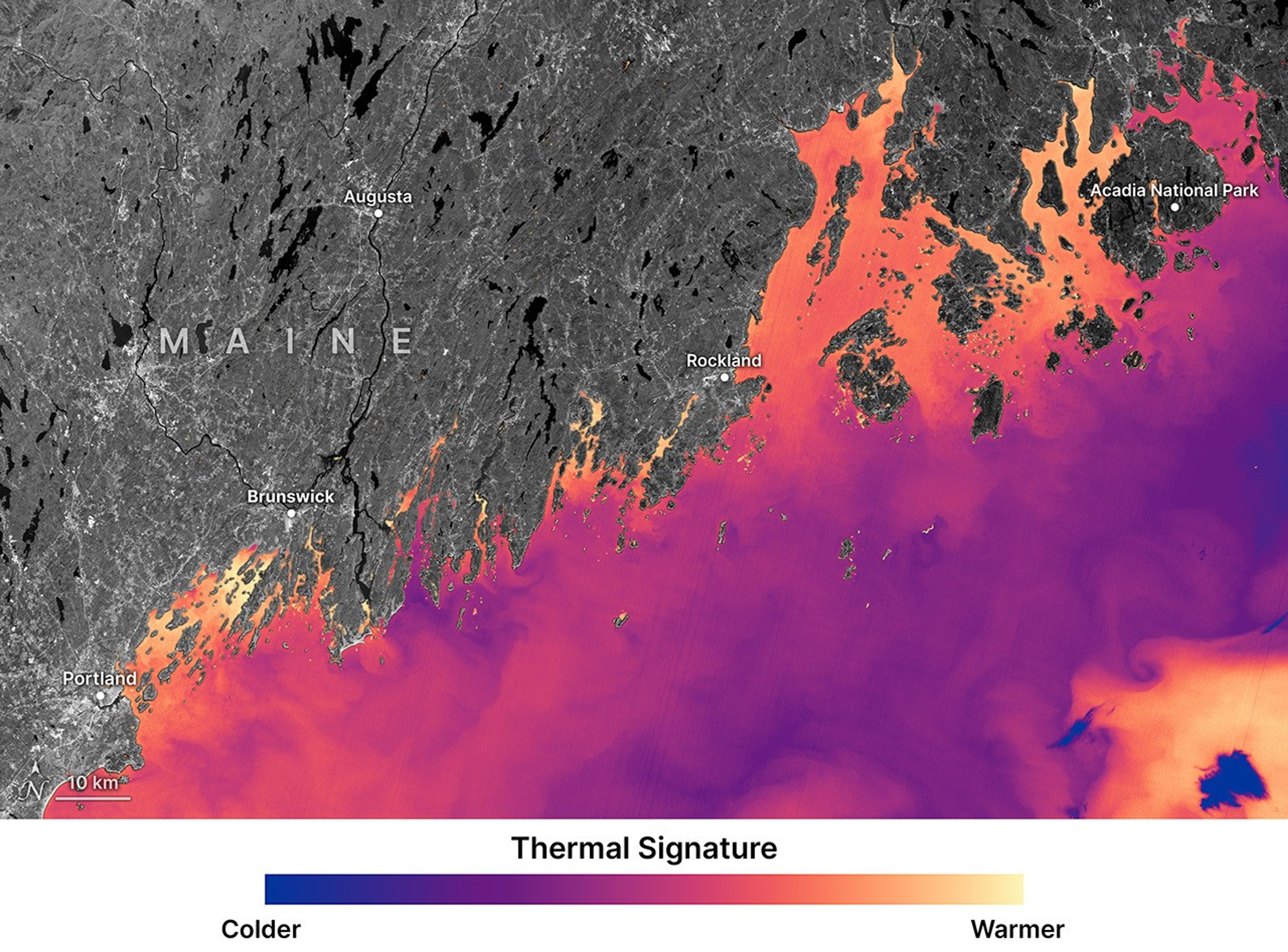
Landsat 8 and 9’s pixels — 98 to 328 feet (30 to 100 meters) across — are able to distinguish more subtle temperature differences between neighboring coves. For a cold-blooded oyster, those distinctions can translate into months of growth. Warm water accelerates feeding and shell development. Cold water slows both.
A challenge for satellites is clouds. Maine’s sky is frequently overcast, and together Landsat 8 and 9 pass over any given point only every eight days. To work around this, the research team analyzed 10 years of Landsat data (2013–2023) and built seasonal “climatologies,” or average temperature patterns for every 98-foot (30-meter) pixel along the coast. Sentinel-2 imagery added estimates of chlorophyll and particulate organic matter, the drifting microscopic food that oysters pull from the water column with rhythmic contractions of their gills.
Field tests at multiple sites showed the technique’s accuracy. “We validated the model against seven years of field data,” Brady said. “It’s a strong indication that these remotely sensed products can inform not just where to grow, but how long it will take to harvest.”
Turning satellite science into tools for growers
The University of Maine team is now developing an online tool to put this model into practice. A grower will be able to click on a coastal location and receive an estimate for time-to-market.
The researchers also assist with workshops through Maine’s Aquaculture in Shared Waters program, teaching farmers how to interpret temperature and water clarity data and apply them to their own sites.
For farmers like Saindon, that translates into something simpler: confidence and efficiency. “Having these kinds of tools lowers the barrier for new people to get into aquaculture,” he said. “It gives you peace of mind that you’re not just guessing.”
The Maine project is helping pave the way for other NASA missions. The PACE satellite (Plankton, Aerosol, Cloud, ocean Ecosystem) launched in 2024 and is now delivering hyperspectral observations of coastal waters. Where earlier sensors could estimate how much plankton was present, PACE can begin to identify the different plankton species themselves. For oysters, mussels, and other filter feeders, that specificity matters. Not all plankton are equal food: Different kinds offer different nutrition, and some plankton are harmful to oysters.
A next step will be turning that richer picture of coastal life into forecasts people working on the water can use, helping farmers trade some of the coast’s mystery for evidence they can apply to their harvest.
By Emily DeMarco
NASA’s Goddard Space Flight Center, Greenbelt, Md.
Share
Details
Related Terms


Related Posts
Stay Informed With the Latest & Most Important News
Previous Post
Next Post


Advertisement
-
 01Two Black Holes Observed Circling Each Other for the First Time
 -
 02From Polymerization-Enabled Folding and Assembly to Chemical Evolution: Key Processes for Emergence of Functional Polymers in the Origin of Life
 -
 03Astronomy 101: From the Sun and Moon to Wormholes and Warp Drive, Key Theories, Discoveries, and Facts about the Universe (The Adams 101 Series)
 -
 04True Anomaly hires former York Space executive as chief operating officer
 -
 05Φsat-2 begins science phase for AI Earth images
 -
 06Hurricane forecasters are losing 3 key satellites ahead of peak storm season − a meteorologist explains why it matters
 -
 07Binary star systems are complex astronomical objects − a new AI approach could pin down their properties quickly