
Now Reading: New MetOp Second Generation weather satellite returns first data
-
01
New MetOp Second Generation weather satellite returns first data


02/09/2025
1304 views
19 likes
Less than three weeks since the first MetOp Second Generation weather satellite, MetOp-SG-A1, was launched, this remarkable new satellite has already started transmitting data from two of its cutting-edge instruments, offering a tantalising glimpse of what’s to come.
The MetOp Second Generation (MetOp-SG) mission builds on the proven success of the first-generation MetOp satellites, securing the flow of vital data for global weather forecasting and climate monitoring – while introducing major advancements in performance and resolution.
As extreme and unpredictable weather events become more frequent, precise and timely forecasting has never been more critical. Operating from polar orbit, the MetOp-SG satellites will provide the essential data needed to strengthen weather prediction models and deepen our understanding of Earth’s changing climate.
The mission consists of three successive pairs of satellites, each pair made up of an A-type and a B-type satellite carrying complementary instruments to capture a wide range of observations.
This mission is the result of long-standing collaboration between ESA and Eumetsat. ESA is responsible for the design and development of the satellites, while Eumetsat manages the launch services, ground segment development, satellite operations and distribution of data to the meteorological community.
Launched on 13 August, aboard an Ariane 6 rocket from the European Spaceport in French Guiana, Eumetsat is currently putting MetOp-SG-A1 through a rigorous commissioning phase.
Despite this new satellite only being in orbit for three weeks and the commissioning is at a very early stage, its Microwave Sounder (MWS) and Radio Occultation (RO) sounder are already returning early ‘first glimpse’ data, marking a significant milestone in a new era of European weather and climate monitoring.
The MWS provides temperature and humidity profiles. It combines MetOp’s original Advanced Microwave Sounding Unit-A (AMSU-A1 and AMSU-A2) and Microwave Humidity Sound (MHS) into a single antenna instrument with new channels for temperature, humidity sounding and ice-cloud detection. The horizontal resolution of the temperature sounding channels has improved from around 48 km to 20 km at nadir.
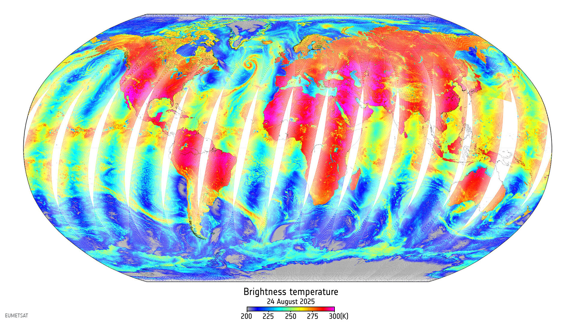
The instrument began sensing just one week after launch – and the striking image presented above is a 24-hour capture from 24 August from its Channel 17. Besides Earth’s surface properties, this channel is also sensitive to convective clouds, shown as various filaments and banding structures over the oceans. For instance, the red swirl visible in the North Atlantic reflects the deep convective cloud system of ex-hurricane Erin.
The next image, from MWS Channel 2, clearly shows a swath of summer ‘brightness temperatures’ (in Kelvin) over land and ocean over Europe.
In reality, information from MWS’s 24 different channels will not be used in isolation, they will be combined to yield atmospheric temperature and humidity data products at different altitudes above Earth.
The RO sounder delivers detailed profiles of atmospheric temperature and humidity across both the troposphere and ionosphere. Building on the heritage of the first-generation GNSS Receiver for Atmospheric Sounding (GRAS) instrument on the first generation of MetOp satellites, the new instrument triples the number of radio occultation measurements – providing more than 1600 observations per day. This leap in coverage is made possible by incorporating signals not only from GPS, but also from Europe’s Galileo and China’s BeiDou satellite navigation constellations.
As the image shows, the new coverage includes much of the global ocean, where data were previously relatively sparse.
The image uses occultations between 20 and 26 August. The smaller plots show vertical temperature and humidity profiles derived from the instrument’s first measurements on 20 August over the Southern Pacific. The curves are plotted alongside ECMWF forecast data, revealing how RO measurements refine and update temperature and humidity structure predictions, particularly in data-sparse regions.
Both the MWS and RO will provide inputs of unprecedented precision for numerical weather predication. While these early signals show that progress is continuing at pace, the data are not yet operationally qualified, and the commissioning of Metop-SG-A1 is expected to require months of thorough testing and calibration before any data are released to Member State meteorological services and other users.
Phil Evans, Eumetsat Director-General, said, “Receiving these first data so quickly is a thrilling achievement for Eumetsat, particularly considering the technological sophistication of Metop-SG-A1 and its payload.
“In collaboration with ESA and our European industry partners, Eumetsat teams are working intensely to render all the satellite’s instruments operational, and the fact that data is already flowing seamlessly from the MWS and the RO shows that we are firmly on the right track to having powerful, validated products ready for our user community in the planned timeframe.”
Simonetta Cheli, ESA’s Director of Earth Observation Programmes, said, “These first glimpses of data are extremely encouraging, and I want to thank all the teams who have contributed –both to developing the mission as a whole and to operating and commissioning MetOp-SG-A1 in orbit.
“This is a major undertaking: six satellites in total, flying in successive pairs and delivering critical data for at least the next 20 years. While we closely monitor MetOp-SG-A1’s early performance, we are already in the final stages of preparing its companion, MetOp-SG-B1, for launch next year. “Together, the polar-orbiting MetOp-SG mission and the geostationary Meteosat Third Generation mission place Europe firmly at the forefront of global weather forecasting.”


Related Posts


Stay Informed With the Latest & Most Important News
Previous Post
Next Post


Advertisement
-
 01Two Black Holes Observed Circling Each Other for the First Time
 -
 02From Polymerization-Enabled Folding and Assembly to Chemical Evolution: Key Processes for Emergence of Functional Polymers in the Origin of Life
 -
 03Astronomy 101: From the Sun and Moon to Wormholes and Warp Drive, Key Theories, Discoveries, and Facts about the Universe (The Adams 101 Series)
 -
 04True Anomaly hires former York Space executive as chief operating officer
 -
 05Φsat-2 begins science phase for AI Earth images
 -
 06Hurricane forecasters are losing 3 key satellites ahead of peak storm season − a meteorologist explains why it matters
 -
 07Binary star systems are complex astronomical objects − a new AI approach could pin down their properties quickly