
Now Reading: New U.S.-European Sea Level Satellite Will Help Safeguard Ships at Sea
-
01
New U.S.-European Sea Level Satellite Will Help Safeguard Ships at Sea

5 min read
Preparations for Next Moonwalk Simulations Underway (and Underwater)

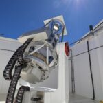
Sea surface height data from the Sentinel-6B satellite, led by NASA and ESA, will help with the development of marine weather forecasts, alerting ships to possible dangers.
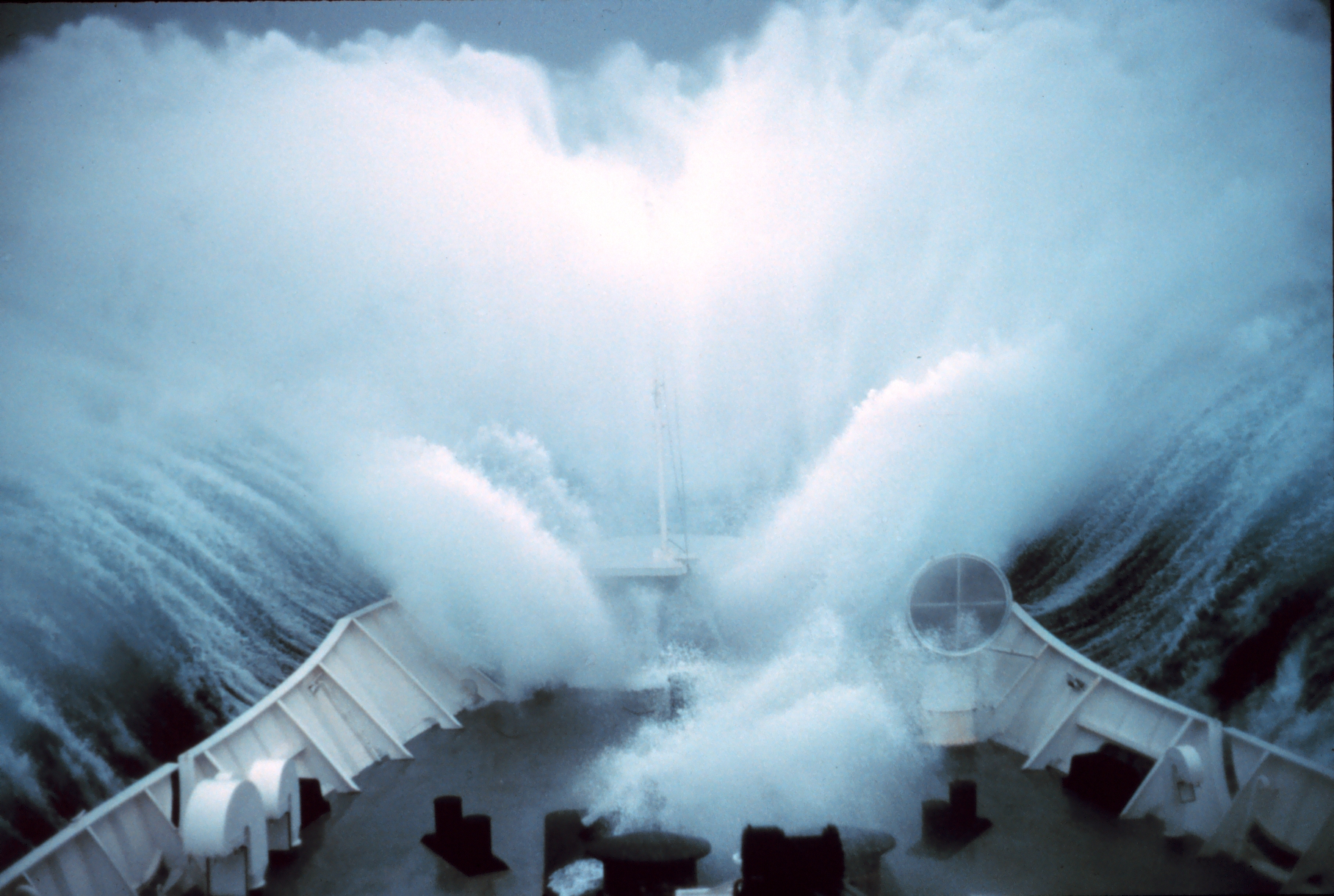
Because most global trade travels by ship, accurate, timely ocean forecasts are essential. These forecasts provide crucial information about storms, high winds, and rough water, and they depend on measurements provided by instruments in the ocean and by satellites including Sentinel-6B, a joint mission led by NASA and ESA (European Space Agency) that will provide essential sea level and other ocean data after it launches this November.
The satellite will eventually take over from its twin, Sentinel-6 Michael Freilich, which launched in 2020. Both satellites have an altimeter instrument that measures sea levels, wind speeds, and wave heights, among other characteristics, which meteorologists feed into models that produce marine weather forecasts. Those forecasts provide information on the state of the ocean as well as the changing locations of large currents like the Gulf Stream. Dangerous conditions can result when waves interact with such currents, putting ships at risk.
“Building on NASA’s long legacy of satellite altimetry data and its real-world impact on shipping operations, Sentinel-6B will soon take on the vital task of improving ocean and weather forecasts to help keep ships, their crews, and cargo safe”, said Nadya Vinogradova Shiffer, lead program scientist at NASA Headquarters in Washington.
Sentinel-6 Michael Freilich and Sentinel-6B are part of the Sentinel-6/Jason-CS (Continuity of Service) mission, the latest in a series of ocean-observing radar altimetry missions that have monitored Earth’s changing seas since the early 1990s. Sentinel-6/Jason-CS is a collaboration between NASA, ESA, the European Union, EUMETSAT (European Organisation for the Exploitation of Meteorological Satellites), and NOAA (U.S. National Oceanic and Atmospheric Administration). The European Commission provided funding support, and the French space agency CNES (Centre National d’Études Spatiales) contributed technical support.
Keeping current
“The ocean is getting busier, but it’s also getting more dangerous,” said Avichal Mehra, deputy director of the Ocean Prediction Center at the National Weather Service in College Park, Maryland. He and his colleagues produce marine weather forecasts using data from ocean-based instruments as well as complementary measurements from five satellites, including Sentinel-6 Michael Freilich. Among those measurements: sea level, wave height, and wind speed. The forecasters derive the location of large currents from changes in sea level.
One of the planet’s major currents, the Gulf Stream is located off the southeastern coast of the United States, but its exact position varies. “Ships will actually change course depending on where the Gulf Stream is and the direction of the waves,” said Mehra. “There have been instances where, in calm conditions, waves interacting with the Gulf Stream have caused damage or the loss of cargo containers on ships.”
Large, warm currents like the Gulf Stream can have relatively sharp boundaries since they are generally higher than their surroundings. Water expands as it warms, so warm seawater is taller than cooler water. If waves interact with these currents in a certain way, seas can become extremely rough, presenting a hazard to even the largest ships.
“Satellite altimeters are the only reliable measurement we have of where these big currents can be,” said Deirdre Byrne, sea surface height team lead at NOAA in College Park.
There are hundreds of floating sensors scattered about the ocean that could pick up parts of where such currents are located, but these instruments are widely dispersed and limited in the area they measure at any one time. Satellites like Sentinel-6B offer greater spatial coverage, measuring areas that aren’t regularly monitored and providing essential information for the forecasts that ships need.
Consistency is key
Sentinel-6B won’t just help marine weather forecasts through its near-real-time data, though. It will also extend a long-term dataset featuring more than 30 years of sea level measurements, just as Sentinel-6 Michael Freilich does today.
“Since 1992, we have launched a series of satellites that have provided consistent sea level observations from the same orbit in space. This continuity allows each new mission to be calibrated against its predecessors, providing measurements with centimeter-level accuracy that don’t drift over time,” said Severine Fournier, Sentinel-6B deputy project scientist at NASA’s Jet Propulsion Laboratory in Southern California.
This long-running, repeated measurement has turned this dataset into the gold standard sea level measurement from space — a reference against which data from other sea level satellites is checked. It also serves as a baseline, giving forecasters a way to tell what ocean conditions have looked like over time and how they are changing now. “This kind of data can’t be easily replaced,” said Mehra.
More about Sentinel-6B
Sentinel-6/Jason-CS was jointly developed by ESA, EUMETSAT, NASA, and NOAA, with funding support from the European Commission and technical support from CNES.
A division of Caltech in Pasadena, JPL contributed three science instruments for each Sentinel-6 satellite: the Advanced Microwave Radiometer, the Global Navigation Satellite System – Radio Occultation, and the Laser Retroreflector Array. NASA is also contributing launch services, ground systems supporting operation of the NASA science instruments, the science data processors for two of these instruments, and support for the U.S. members of the international Ocean Surface Topography and Sentinel-6 science teams.
For more about Sentinel-6/Jason-CS, visit:
https://sealevel.jpl.nasa.gov/missions/jason-cs-sentinel-6
News Media Contacts
Jane J. Lee / Andrew Wang
Jet Propulsion Laboratory, Pasadena, Calif.
626-491-1943 / 626-379-6874
jane.j.lee@jpl.nasa.gov / andrew.wang@jpl.nasa.gov
2025-116
Share
Details
Related Terms
Explore More


Related Posts

Stay Informed With the Latest & Most Important News
Previous Post
Next Post


Advertisement
-
 01Two Black Holes Observed Circling Each Other for the First Time
 -
 02From Polymerization-Enabled Folding and Assembly to Chemical Evolution: Key Processes for Emergence of Functional Polymers in the Origin of Life
 -
 03Astronomy 101: From the Sun and Moon to Wormholes and Warp Drive, Key Theories, Discoveries, and Facts about the Universe (The Adams 101 Series)
 -
 04True Anomaly hires former York Space executive as chief operating officer
 -
 05Φsat-2 begins science phase for AI Earth images
 -
 06Hurricane forecasters are losing 3 key satellites ahead of peak storm season − a meteorologist explains why it matters
 -
 07Binary star systems are complex astronomical objects − a new AI approach could pin down their properties quickly