
Now Reading: Peering into the eye of Hurricane Melissa | Space photo of the day for Oct. 30, 2025
-
01
Peering into the eye of Hurricane Melissa | Space photo of the day for Oct. 30, 2025

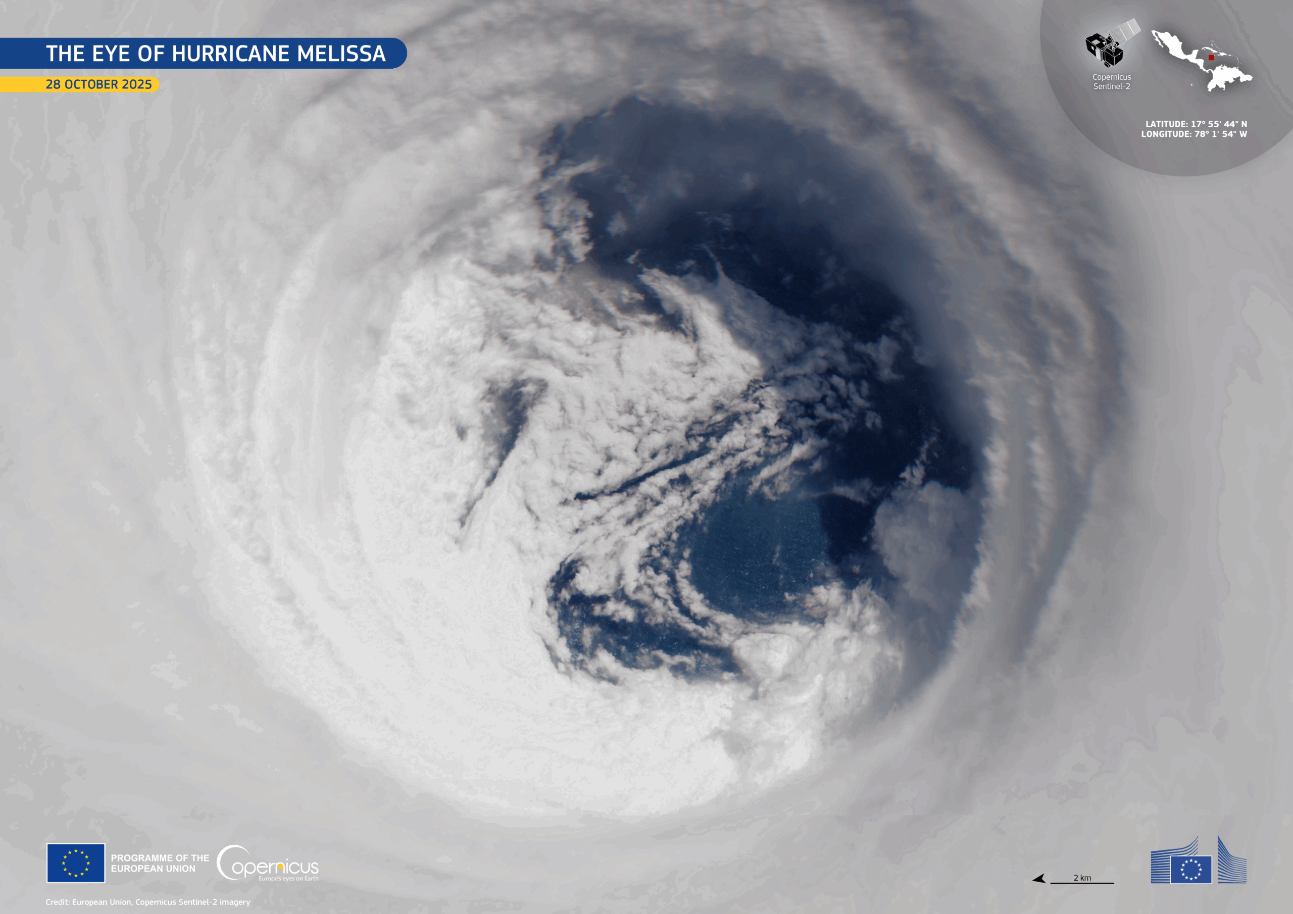
High above Earth, satellites like the European Union’s Copernicus Sentinel-2 watch and track storms such as Hurricane Melissa, a category 5 maelstrom. These satellites help keep continuous eyes on the tempest and provide valuable data about how these natural disasters form and how they can impact communities in a changing world.
What is it?
Because the data is freely available to researchers under the Copernicus program, scientists can support disaster management, build better early warning systems, and have better insights into how global warming and climate change are affecting hurricanes.
Where is it?
Hurricane Melissa made landfall in Jamaica on Oct. 28, 2025.

Why is it amazing?
Hurricane Melissa underwent a period of rapid intensification, becoming one of the most powerful storms in the Atlantic in 2025. When it made landfall in Jamaica on Oct. 28, 2025, it was the most powerful storm in the country’s history. Monitoring how storms change is crucial because intensification rates are hard to predict, and stronger storms mean higher risk of catastrophic damage.
Understanding and analyzing the processes behind hurricane intensification, via the use of satellites like Sentinel-2, can help to improve hurricane forecasting and, in the process, save lives.
Want to learn more?
You can learn more about Earth-monitoring satellites and the European Space Agency.


Related Posts

Stay Informed With the Latest & Most Important News
Previous Post
Next Post


Advertisement
-
 01Two Black Holes Observed Circling Each Other for the First Time
 -
 02From Polymerization-Enabled Folding and Assembly to Chemical Evolution: Key Processes for Emergence of Functional Polymers in the Origin of Life
 -
 03Astronomy 101: From the Sun and Moon to Wormholes and Warp Drive, Key Theories, Discoveries, and Facts about the Universe (The Adams 101 Series)
 -
 04True Anomaly hires former York Space executive as chief operating officer
 -
 05Φsat-2 begins science phase for AI Earth images
 -
 06Hurricane forecasters are losing 3 key satellites ahead of peak storm season − a meteorologist explains why it matters
 -
 07Binary star systems are complex astronomical objects − a new AI approach could pin down their properties quickly