
Now Reading: Recipe for a ‘rocky road’ crater soaked in martian history
-
01
Recipe for a ‘rocky road’ crater soaked in martian history


21/05/2025
12 views
0 likes
To create a crumbly crater rich in ice and chunky blocks soaked in layers of martian history – like this one recently observed by the European Space Agency’s Mars Express – follow this recipe:
- Toss a space rock into Mars to form a classic circular base
- Layer with molten lava
- Carve channels with liquid water
- Chill to create ice, and freeze-thaw multiple times to slowly expand crater edges
- Sprinkle generously with volcanic dust, and leave to set
- Serve to hungry Mars fans!
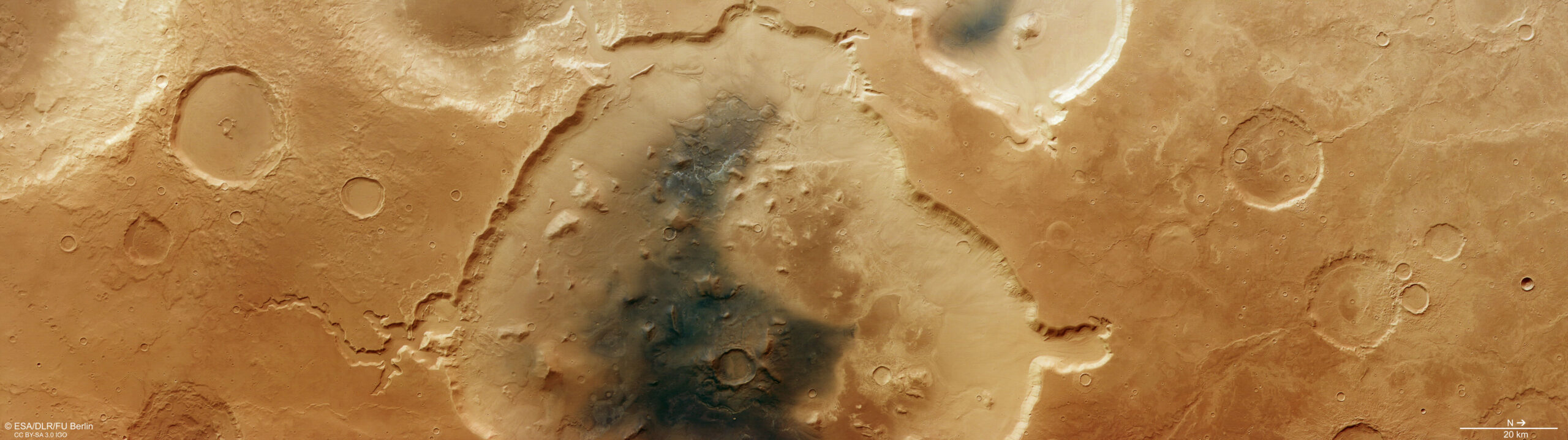
The new image, taken by Mars Express’s High Resolution Stereo Camera (HRSC) in October 2024, showcases Deuteronilus Cavus, a roughly 120 km-wide depression situated in the transitional zone between the planet’s rugged southern highlands and smoother northern lowlands.
The feature has been a long time in the making, preserving details from volcanic, glacial, water and wind-related activity across four billion years of history.
Its nearly circular shape suggests an impact crater origin. The collision likely happened around 4.1–3.7 billion years ago, when the planet was being peppered by asteroids and comets. Over time, erosion by water and ice has reshaped the original crater, enlarging it to nearly twice its initial size.
The crater rim is cut by channels (see ‘branched channel’ closeup). These channels may have initially formed from water flowing across Mars’s surface, or as water under the surface drained away, collapsing the weakened surface above.
The grooved surface texture in some of the channels and alcoves cut into the crater rim points to previously present ice. The linear grooves indicate where boulders frozen into the base of a glacier were dragged along, gouging out the troughs visible today.
Around the base of the crater’s inner walls, we can see the smooth, tongue-shaped ends of rock-covered glaciers (see ‘glacial flow’ closeup). These ‘debris aprons’ formed when ice mixed together with rocky debris along the crater walls during a period of glaciation, and slowly crept downslope.
Deuteronilus Cavus is situated in the mid-latitudes of Mars, so the glaciers are thought to have formed in this region when the planet’s axis was more dramatically tilted away from the Sun than it is today.
Inside the crater is a jumbled mixture of chunky knobs, mesas, channels and smoother plains, reminiscent of ‘rocky road’ refrigerator cake (see ‘jumbled blocks’ closeup). Instead of marshmallows standing above a sea of melted chocolate, here we have stronger blocks of rock (knobs and mesas) that have resisted erosion from wind, water or ice flowing around them. The blocks could well be the remnants of a collapsed peak of rock that once stood in the centre of the crater, although this complex collection of features is typical of the wider region in general.
Much of the crater interior is covered by a dark deposit, likely wind-blown volcanic ash. The brighter deposits shining through the dark material are known to contain clay minerals, formed by volcanic ash mixing with water, suggesting that liquid water may have ponded here for some time.
Further evidence of volcanic activity is seen in the ‘wrinkle ridges’ that ripple across the smoother terrain that surrounds the crater, formed as lava flows cooled and contracted.
This feature-rich crater has all the ingredients for exploring Mars’s varied geological processes, giving us a tantalising taste of its complex history.
ESA’s Mars Express has been observing and analysing Mars’s many landscapes for more than two decades, returning insights that have drastically changed our understanding of our planetary neighbour. Explore more, here.
Notes for editors:
The Mars Express High Resolution Stereo Camera (HRSC) was developed and is operated by the German Aerospace Center (Deutsches Zentrum für Luft- und Raumfahrt; DLR). The systematic processing of the camera data took place at the DLR Institute of Planetary Research in Berlin-Adlershof. The working group of Planetary Science and Remote Sensing at Freie Universität Berlin used the data to create the image products shown here.
For more information please contact:
ESA Media Relations, media@esa.int


Related Posts
Stay Informed With the Latest & Most Important News


Advertisement
-
 01Two Black Holes Observed Circling Each Other for the First Time
 -
 02From Polymerization-Enabled Folding and Assembly to Chemical Evolution: Key Processes for Emergence of Functional Polymers in the Origin of Life
 -
 03Astronomy 101: From the Sun and Moon to Wormholes and Warp Drive, Key Theories, Discoveries, and Facts about the Universe (The Adams 101 Series)
 -
 04True Anomaly hires former York Space executive as chief operating officer
 -
 05Φsat-2 begins science phase for AI Earth images
 -
 06Hurricane forecasters are losing 3 key satellites ahead of peak storm season − a meteorologist explains why it matters
 -
 07Binary star systems are complex astronomical objects − a new AI approach could pin down their properties quickly