
Now Reading: Revisiting Roswell Uncovers Truth Behind UFO Crash Imagery
-
01
Revisiting Roswell Uncovers Truth Behind UFO Crash Imagery


The Roswell incident has long been a focal point in UFO lore, invoking intrigue and speculation that has lasted over seven decades. However, the true nature of the crash site and its surroundings is often muddied by misinformation, particularly in the sphere of photography. Numerous purported images of the crash site have circulated online, but discerning the genuine from the fabricated requires a deeper understanding of the actual terrain and the historical context surrounding the event.
To clarify the geography, it very important to note that the Roswell crash site is characterized by its open expanse typical of the high desert environment. This landscape is not defined by sandy dunes, as many may assume, but rather features sparse vegetation and rocky terrain. The terrain has remained relatively unchanged, offering a clear view of the land long after the 1947 events.
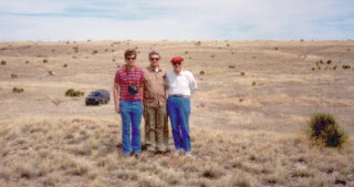
Photographers who visited the site decades later have captured images that reveal the truth about the crash area. For example, during our visit, we documented various sites associated with the incident, taking care to photograph the actual debris field and the impact site. I had the privilege of capturing several photos myself, while others joined in to record our endeavor. In one such image, I can be seen alongside Tom Carey and Don Schmitt, who are both well-versed in the intricacies of the Roswell case.
One striking aspect of our photographs is how they reveal the open nature of the ground surrounding the sites. Here are some observations from our visits:
- Debris Field: Identified in the early 1990s by Bill Brazel, the debris field offers a glimpse into the broader extent of the crash’s impact. The area is marked by scattered remnants that suggest a broader dispersal of materials than one might expect from a singular impact.
- Impact Site: The impact site, where the supposed craft first made contact with the ground, showcases a clear view of the rugged landscape. It’s essential for enthusiasts and researchers to appreciate how the geography may have influenced the fallout from the event.
- Open Ground: The lack of dense terrain provides insight into how witnesses could have observed the incident and the aftermath. There’s a stark contrast between the imagery circulating online and what can actually be seen at the sites—an errant depiction that can mislead those engrossed in UFO phenomena.
For anyone attempting to navigate the plethora of photographs associated with Roswell, it is important to approach this topic with skepticism. The BLM (Bureau of Land Management) oversees much of the land where these events occurred, and understanding the parameters of this territory can provide clarity. When viewing images, ponder the following:
- Examine the vegetation and terrain in the photos. Does it match the recognizable features of the Roswell crash sites?
- Research the source of the images. Are they attributed to reputable researchers or photographers who have conducted on-site investigations?
- Look for context in the images. Are they linked to credible accounts and timelines that align with historical records?
Exploration and documentation of the Roswell incident continue to intrigue not just UFO enthusiasts but also those interested in the scientific and historical implications of such events. By returning to the actual crash sites and capturing images that reflect the reality of the landscape, we can better separate fact from fiction. Therefore, it’s essential to rely on credible documentation and firsthand accounts, as these provide a more grounded perspective on the infamous Roswell crash.
| Key Features of the Roswell Crash Sites |
| Terrain Type: Open desert with sparse vegetation |
| Site Accessibility: Located on BLM land or private property |
| Photographic Evidence: Captured by credible sources well after 1947 |
As the dialogue surrounding Roswell evolves, it is the responsibility of researchers and enthusiasts alike to sift through the noise and seek out the truth behind the phenomenon. The true images of the crash site, taken years after the initial event, serve as vital checkpoints in this ongoing journey of discovery.


Related Posts

Stay Informed With the Latest & Most Important News
Previous Post
Next Post


Advertisement
-
 01Two Black Holes Observed Circling Each Other for the First Time
 -
 02From Polymerization-Enabled Folding and Assembly to Chemical Evolution: Key Processes for Emergence of Functional Polymers in the Origin of Life
 -
 03Astronomy 101: From the Sun and Moon to Wormholes and Warp Drive, Key Theories, Discoveries, and Facts about the Universe (The Adams 101 Series)
 -
 04True Anomaly hires former York Space executive as chief operating officer
 -
 05Φsat-2 begins science phase for AI Earth images
 -
 06Hurricane forecasters are losing 3 key satellites ahead of peak storm season − a meteorologist explains why it matters
 -
 07Binary star systems are complex astronomical objects − a new AI approach could pin down their properties quickly