
Now Reading: Rhea Space Activity applies optical navigation to military rendezvous missions
-
01
Rhea Space Activity applies optical navigation to military rendezvous missions


WASHINGTON — Rhea Space Activity, a Washington, D.C.-based space technology startup, is adapting navigation software originally developed by NASA for military use under a U.S. Space Force contract, targeting a long-standing vulnerability in satellite operations: reliance on GPS.
The company is one of 10 firms selected last year by the Space Force’s SpaceWERX organization under its Sustained Space Maneuver Challenge, an open competition designed to accelerate technologies that improve satellite mobility and resilience. The effort is focused on operating in contested orbital environments, where U.S. spacecraft may face threats ranging from debris to anti-satellite weapons.
Each company selected under the challenge received a Small Business Innovation Research “Direct to Phase 2” contract worth about $1.9 million. The 15-month awards, sponsored by U.S. Space Command and run by SpaceWERX, are intended to push promising concepts toward more mature prototype demonstrations aligned with military operational needs.
Under its award, Rhea Space Activity is developing autonomous navigation software through a project called Vanguard — short for Vision-based Autonomous Navigation and Guidance for Unassisted Approach, Rendezvous and Deployment. The work builds on AutoNav, a software suite originally developed at NASA Jet Propulsion Laboratory to allow spacecraft to determine their position and trajectory without continuous guidance from Earth.
Jake Singh, a missile system guidance, navigation and control engineer at Rhea Space Activity and the principal investigator for Vanguard, said the company saw a clear military application for the technology.
“AutoNAV is the key capability that we have,” Singh told SpaceNews.
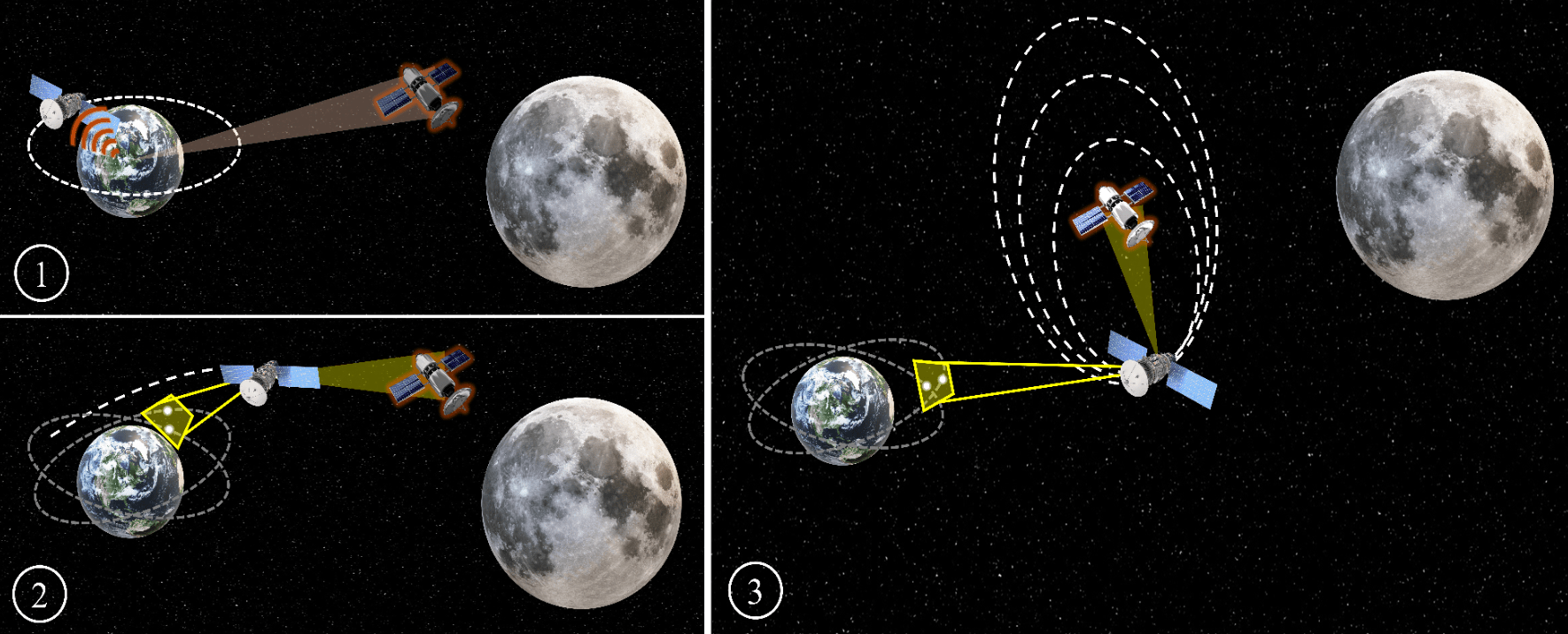
AutoNav allows a spacecraft to navigate using onboard sensors — typically optical cameras — to observe known objects in space. The software processes those images in real time, compares them to stored ephemerides and star catalogs and computes where the spacecraft is and where it is heading. From there, it can update the onboard navigation solution and, in some cases, plan or refine maneuvers autonomously. The software was commercialized into private industry and is now owned by Rhea Space Activity.
Singh said the Vanguard effort extends AutoNav by adding support for autonomous rendezvous and proximity operations, or RPO, in Earth orbit.
Inspection, characterization of objects
RPO refers to a class of spaceflight activities in which one spacecraft deliberately approaches and maneuvers near another object, sometimes close enough to inspect or interact with it. These operations are technically demanding, requiring precise navigation, continuous situational awareness and careful control to avoid collisions.
Such capabilities are central to military and intelligence missions involving inspection or characterization of objects in orbit, particularly in environments where GPS may be unavailable and communication delays limit reliance on real-time commands from Earth.
AutoNav, combined with a camera and a flight computer, can provide GPS-denied navigation and guidance by imaging the sky and cross-referencing stars and satellites against known positions stored in the Space Force’s Unified Data Library, the company said.
Singh said Rhea Space is demonstrating the software in a physics-based simulation environment. This approach models spacecraft behavior by applying the underlying laws of physics rather than relying solely on historical data or statistical trends, allowing engineers to explore complex scenarios that would be difficult to test on orbit.
“We are running our flight software on representative hardware through simulated RPO scenarios in low-Earth and geostationary orbits to evaluate and improve its capabilities, and developing tools for operators to automate missions,” he said.
If the project advances beyond the current phase, Rhea Space said the software could eventually be integrated into flight cameras for on-orbit demonstrations aboard Space Force satellites, offering a potential path toward more autonomous, GPS-independent space operations.


Related Posts
Stay Informed With the Latest & Most Important News
Previous Post
Next Post


Advertisement
-
 01Two Black Holes Observed Circling Each Other for the First Time
 -
 02From Polymerization-Enabled Folding and Assembly to Chemical Evolution: Key Processes for Emergence of Functional Polymers in the Origin of Life
 -
 03Astronomy 101: From the Sun and Moon to Wormholes and Warp Drive, Key Theories, Discoveries, and Facts about the Universe (The Adams 101 Series)
 -
 04True Anomaly hires former York Space executive as chief operating officer
 -
 05Φsat-2 begins science phase for AI Earth images
 -
 06Hurricane forecasters are losing 3 key satellites ahead of peak storm season − a meteorologist explains why it matters
 -
 07Binary star systems are complex astronomical objects − a new AI approach could pin down their properties quickly