
Now Reading: Satellite Images Reveal Alarming Glacier Retreat in Chile Due to Climate Change
-
01
Satellite Images Reveal Alarming Glacier Retreat in Chile Due to Climate Change

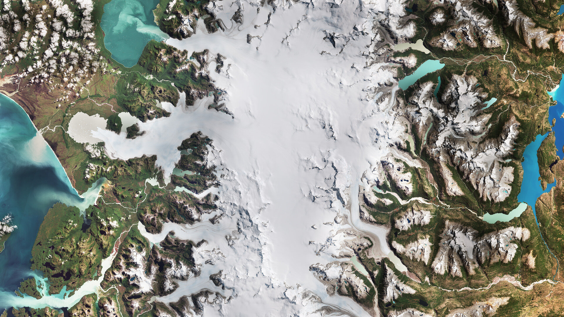

Recent satellite imagery highlights significant changes in the glaciers of Laguna San Rafael National Park in southern Chile, showcasing the dramatic impact of climate change over the past several decades. The park, which spans approximately 17,000 square kilometers along the Pacific coast, is home to the Northern Patagonian Ice Field, a remnant of the expansive Patagonian Ice Sheet that once blanketed the region. Although the ice field has diminished considerably, it remains the second-largest contiguous ice mass outside the polar regions.
The satellite comparison features images taken on February 9, 1987, and again on February 9, 2024, from the Landsat-5 and Copernicus Sentinel-2 missions, respectively. The shrinking glaciers, including the two largest, San Rafael and San Quintín, are prime examples of how rising global temperatures have contributed to their significant retreat.
San Rafael Glacier, located in the upper left of the images, stands out as one of the most active calving glaciers worldwide. It discharges ice into a distinctive, crescent-shaped body of water, known as Laguna San Rafael, which has formed as the glacier recedes. This lake, along with many others in the region, is sustained by meltwater from the glaciers. The satellite images reveal a striking variation in water color, ranging from dark blue to aquamarine, indicative of varying levels of fine sediment—often referred to as ‘glacier milk’—suspended in the water due to glacial movement over bedrock. The presence of icebergs floating in San Rafael Lake further exemplifies the ongoing glacial activity.
Beneath San Rafael, the San Quintín Glacier, the second largest in the ice field, also illustrates the dramatic effects of climate change. The 1987 image shows the glacier nearly terminating on solid ground, while by 2024, the retreat has created a proglacial lake in the basin once occupied by the glacier’s terminus.
Globally, glaciers are facing similar challenges as climate change accelerates the melting of ice sheets and glaciers, contributing to rising sea levels. These rising waters represent a significant concern for coastal communities and ecosystems. The use of satellite technology plays an important role in monitoring the changes in glaciers, providing vital data to inform future adaptation strategies in response to the ongoing climate crisis.


Related Posts


Stay Informed With the Latest & Most Important News
Previous Post
Next Post


Advertisement
-
 01Two Black Holes Observed Circling Each Other for the First Time
 -
 02From Polymerization-Enabled Folding and Assembly to Chemical Evolution: Key Processes for Emergence of Functional Polymers in the Origin of Life
 -
 03Astronomy 101: From the Sun and Moon to Wormholes and Warp Drive, Key Theories, Discoveries, and Facts about the Universe (The Adams 101 Series)
 -
 04True Anomaly hires former York Space executive as chief operating officer
 -
 05Φsat-2 begins science phase for AI Earth images
 -
 06Hurricane forecasters are losing 3 key satellites ahead of peak storm season − a meteorologist explains why it matters
 -
 07Binary star systems are complex astronomical objects − a new AI approach could pin down their properties quickly