
Now Reading: Satellite records expose fire driving Gran Chaco transformation
-
01
Satellite records expose fire driving Gran Chaco transformation


26/06/2025
278 views
9 likes
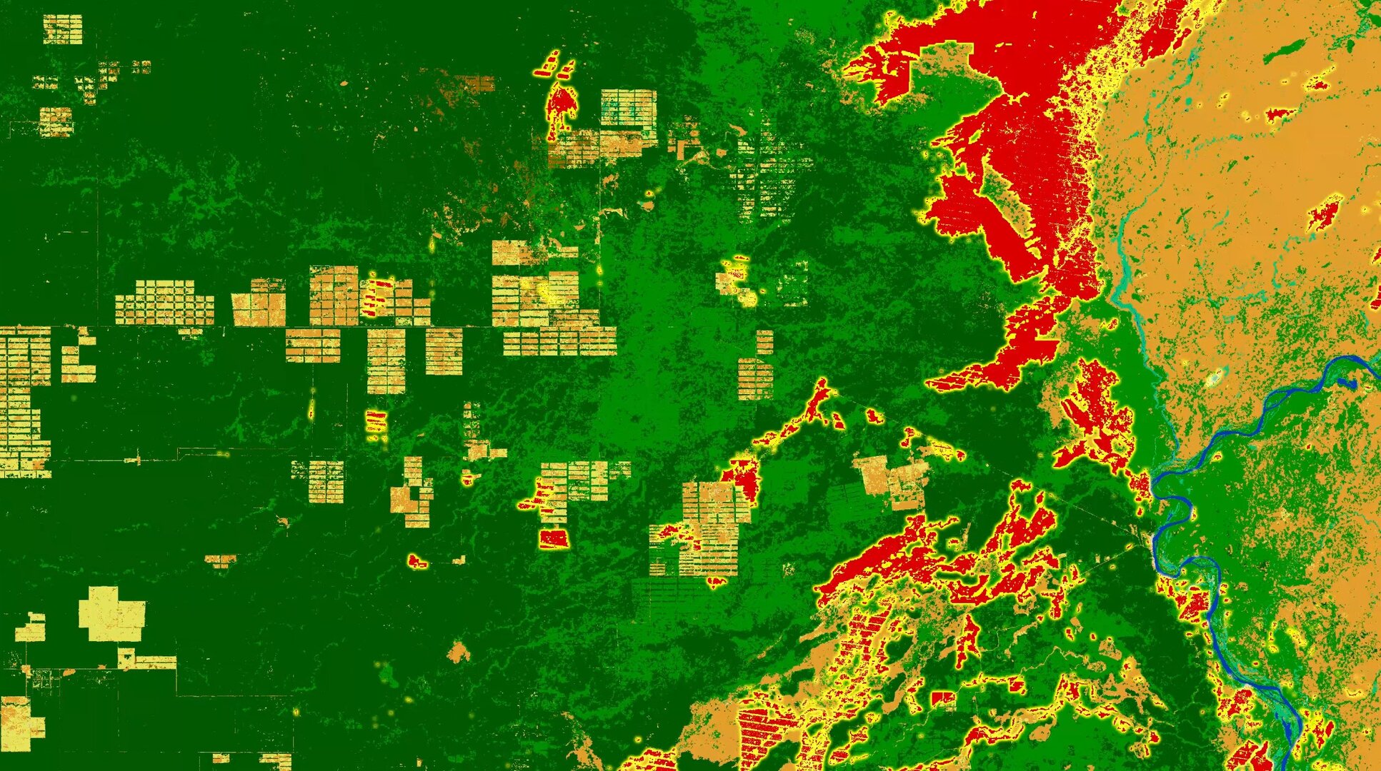
At ESA’s Living Planet Symposium, scientists have unveiled how the combination of different long-term, high-resolution satellite datasets from ESA’s Climate Change Initiative is shedding new light on the South American Gran Chaco – one of the world’s most endangered dry forest ecosystems. These data reveal, in remarkable clarity, that fire is the primary driver of widespread, accelerating deforestation across the region.
Spanning Argentina, Paraguay, Bolivia and parts of Brazil, the Gran Chaco is the second-largest forested biome in South America, and is the largest continuous extent of tropical dry forest in the world. Although less well-known than the neighbouring Amazon rainforest, it is nevertheless a critical deforestation hotspot – largely owing to agricultural expansion.
Fire: a hidden force reshaping the landscape
Superimposing high-resolution satellite maps of land cover and fire-burned area from 1990 to 2019 reveals a clear and recurring pattern: forest clearance is frequently followed by fire in the same location within one or two years.
Tellingly, the shapes and timing match with striking precision – suggesting human influence.
These long-term datasets have been developed by research teams contributing to ESA’s Climate Change Initiative, which merges observations from multiple satellite missions, including Copernicus Sentinel-1, Sentinel-2 and NASA’s Landsat series of satellites.
The records which have a 20–30 metre resolution also have a high degree of temporal and spatial consistency from which to accurately track change.
The sequence of deforestation and then fire detection is unmistakable in the high-resolution data, according to Rodrigo San Martin, a land-system scientist at France’s Laboratory for Climate and Environmental Sciences who has studied the region extensively using medium-resolution 250–300 m satellite data products.
Previous investigations of the region’s fire ecology using medium-resolution products also point to a similar, albeit less precise, sequencing of deforestation and fire detection. Significantly, prominent differences were found in the extent to which fire is used for forest clearing across national borders, further indicating social, economic or political factors at play.
Dr San Martin’s hypothesis for the observed lag is the result of trees, once cut, being left to dry and then deliberately set on fire many months later, often to accelerate the conversion of forest to pasture or cropland.
He said, “This shift from woody forest to land for cattle grazing or crop production releases vast quantities of carbon – particularly when fire is part of the process, so as well as potentially combatting illegal deforestation, encroachment into protected areas and the spread of fires, these new high-resolution records can be used to support national efforts to tackle climate change.”
Powering policy with satellite data
The enhanced satellite data open new avenues for climate science and policy. Clement Albergel, Head of ESA’s Actionable Climate Information Section, notes, “Combining these high-resolution datasets reveal fine details in the landscape and the processes driving the shift from forest to agricultural production.
“The data are also valuable for enhancing the precision of climate and carbon models which are an essential component for climate mitigation planning.
“The data can also be used to refine national land-use and greenhouse-gas inventories to track and report progress with respect to international commitments including the Paris Agreement as well as for forest conservation such as in the UN REDD+ framework and the EU Deforestation Regulation.”
Exploiting long-term record
Land cover and fire are just two of 28 Essential Climate Variable (ECV) datasets developed under ESA’s Climate Change Initiative.
These datasets, while providing the observation records used to characterise the Earth system, are increasingly being used in combination to address cross-cutting climate questions – from sea-level rise to permafrost thaw and changing circulation pattens across the planet’s oceans – to deliver vital insights and support the Paris Agreement and global sustainability goals.
Six new ‘cross-ECV’ projects have been kicked off this year.


Related Posts

Stay Informed With the Latest & Most Important News
Previous Post
Next Post


Advertisement
-
 01Two Black Holes Observed Circling Each Other for the First Time
 -
 02From Polymerization-Enabled Folding and Assembly to Chemical Evolution: Key Processes for Emergence of Functional Polymers in the Origin of Life
 -
 03Astronomy 101: From the Sun and Moon to Wormholes and Warp Drive, Key Theories, Discoveries, and Facts about the Universe (The Adams 101 Series)
 -
 04True Anomaly hires former York Space executive as chief operating officer
 -
 05Φsat-2 begins science phase for AI Earth images
 -
 06Hurricane forecasters are losing 3 key satellites ahead of peak storm season − a meteorologist explains why it matters
 -
 07Binary star systems are complex astronomical objects − a new AI approach could pin down their properties quickly