
Now Reading: Satellites help tackle landfill methane leaks
-
01
Satellites help tackle landfill methane leaks


15/12/2025
125 views
5 likes
Satellites are emerging as a powerful new tool in the fight to curb emissions of methane. While methane is much shorter-lived in the atmosphere than carbon dioxide, it is vastly more potent at trapping heat, which makes rapid cuts essential for slowing warming in the short term. The same satellite technology that has transformed methane monitoring in the oil and gas sector is now being turned towards another major source – landfill sites.
With methane’s heat-trapping power 28 times stronger than carbon dioxide over a century and 80 times more potent over 20 years, commitments to reduce emissions are high on the international agenda, including the Global Methane Pledge which aims for a 30% reduction by 2030.
Landfill sites are potential sources, accounting for over 10% of human-caused methane emissions.
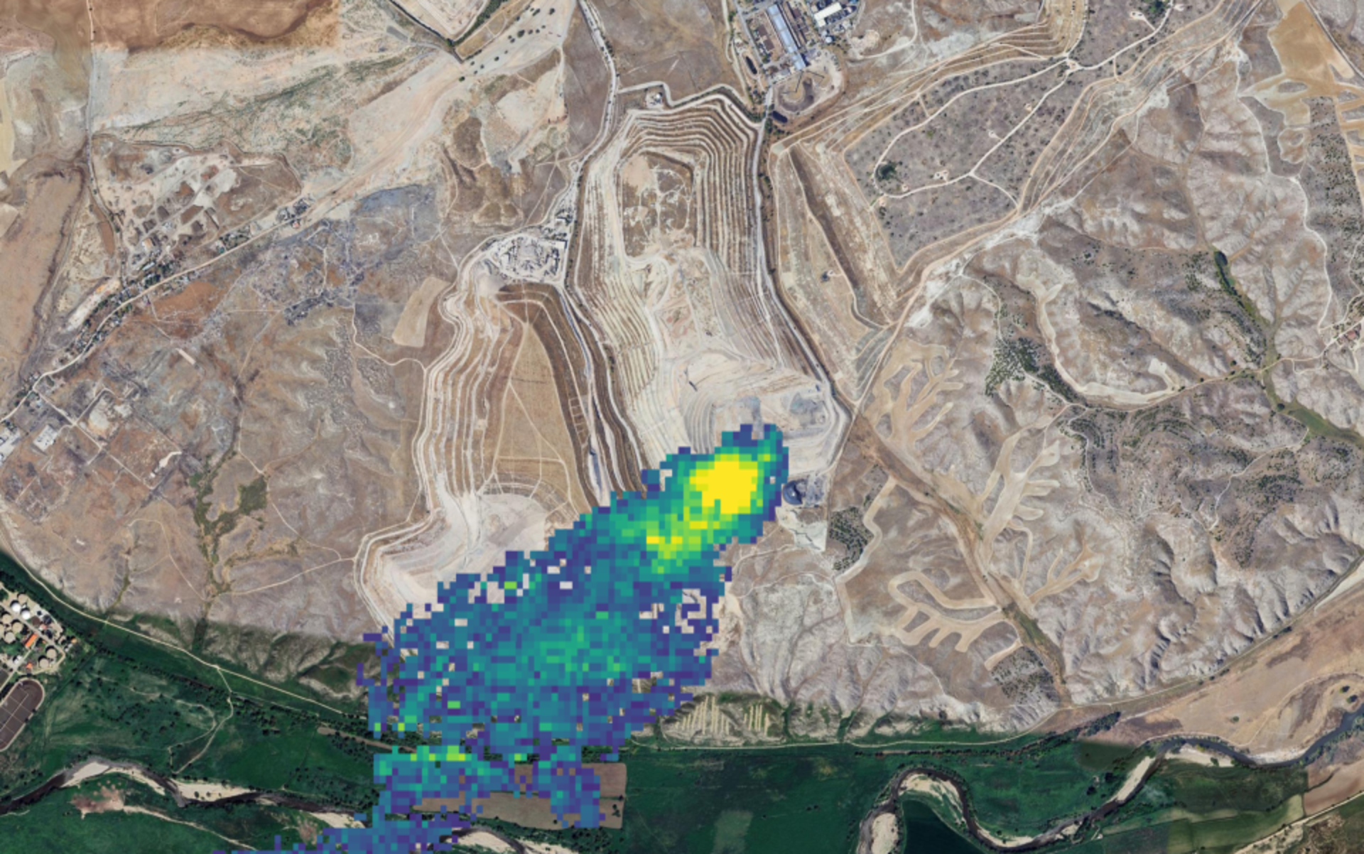
Mapping methane over a landfill site
To test how space-based detection can help find leaks and then assess whether repairs have worked, the European Space Agency has teamed up with leading scientists and the managers of the Las Dehesas landfill (Madrid City Council and its operating company, Urbaser) in a real-world case study in Spain, setting a new benchmark for methane tracking in the waste sector.
Since spring 2025, concurrent measurements of methane emissions have been collected using ground surveys, sensor-equipped aircraft and satellites to assess a landfill site 18 km southeast of Madrid.
The research team, led by Harjinder Sembhi at the University of Leicester as part of ongoing work within and alongside ESA’s Climate Change Initiative MEDUSA project, carried out a high-resolution assessment of the Las Dehesas landfill site and surrounding area.
Data from ESA’s Sentinel-5P mission provide a broad view of methane across entire regions, and high-resolution instruments like those on GHGSat – a Canadian emissions-technology provider leveraging satellites and aircraft – can use this information to zoom in on the exact sources.
In May 2025, GHGSat’s 25 × 25 metre sensor, which is capable of identifying leaks as small as ~100 kg per hour, captured detailed snapshots of methane plumes over the Madrid landfill. At the same time, research aircraft equipped with similar methane-detecting instruments flew low over the site, producing ultra-fine, 1-metre-resolution maps capable of pinpointing even tiny leaks down to just 5 kg per hour.
The surveys were then repeated in September and October to assess the impact of summer repair work, which had included maintenance of gas-collection wells and pipelines, and adjustments to the way the landfill’s surface is managed.
“By combining the frequency of high-resolution satellite measurement with the targeted view of high-resolution airborne measurements, we’re able to gain an unprecedented understanding of how landfill methane behaves. This level of insight empowers operators to target solutions more effectively, and ultimately drive meaningful emissions reduction,” said Dan Wicks, UK Managing Director, GHGSat.
“We had a very clear aim – to use satellite and aircraft measurements to detect leaks and guide on-the-ground remediation activity,” explains Dr Aben, who leads wider efforts to evaluate methane data products derived from a wide range of satellites as part of the MEDUSA project.
“The methane maps we were able to produce provide a way to engage with and help direct on the ground operations and turn observations into real-world action.”
Collaboration key to climate action
Key to the study’s success has been openness and strong collaboration between the Madrid City Council and the Las Dehesas landfill operators on the Valmendigómez Technology Park – and research partners including ESA, GHGSat, the University of Leicester in the UK, the Space Research Organisation Netherlands (SRON), the International Methane Emissions Observatory (IMEO), and the Danish Technical University (DTU).
María José Delgado, Director General of the Valdemingómez Technology Park, expresses the Madrid City Council’s willingness to collaborate on this innovative project, which enables the comparison of different technologies for detecting fugitive emissions of biogas from landfill, thereby improving environmental control in landfill management and contributing to the fight against climate change.
Sharing details of site activity and timing routine on-the-ground monitoring with airborne-based observations provided the science team with crucial context. In turn, researchers’ rapid analysis and mapping helped to identify leak locations and persistence, to guide the landfill operator’s remediation activity.
By focusing on the waste sector, the case study aims to inform satellite-guided pathways to reduce or avoid emissions, mirroring successes targeting oil and gas facilities. Unlike industrial facilities however, emissions from landfills are harder to mitigate, but this exercise indicates that the potential is there.
Dr Sembhi, from the University of Leicester, said, “In many cases, the operator was able to check leak locations as we were disseminating data reports and prioritise action.
“Landfill gas production is generally of a diffuse nature, influenced by dynamic and changing site activity as well as potential influence of prevailing weather and ground conditions.
“Using these new observations, site information and local meteorological data we are investigating the drivers influencing leak occurrence and persistence. Improving understanding should help better quantify emissions and inform practical steps to reduce or avoid emissions.
Previous satellite-based surveys of methane emissions from landfill sites have found little correlation with reported or modelled emission estimates at facility scale, revealing major uncertainties in current understanding.
“The opportunity to work with the operator can help us optimise the use of remote sensing to improve monitoring. This will allow us to identify the reasons for the gap between satellite-based and facility-calculated methane emissions, and lead to real-world emissions reductions,” added Dr Sembhi.
Timon Hummel, ESA’s Mission Manager for Atmospheric Missions added, “Satellites can detect and quantify methane missions faster and with far greater precision than ever before. Using this new scientific insight, the waste sector has the potential to accelerate effective action on the ground, delivering real-world mitigation to support sector, national and global efforts to limit warming to 1.5 °C in line with the Paris Agreement.”
The results of the field study are expected to be available in early 2026, with evaluation of the remediation activity effectiveness currently on-going.
Dr Sembhi noted, “Detection is only one half of the coin. We’re assessing how robust and long-lasting the remediation has been in terms of plugging leaks. Once complete we’ll advance knowledge of monitoring and quantifying waste sector emissions, while laying the groundwork for satellite-driven landfill methane monitoring to support cities and waste managers in cutting emissions.”


Related Posts
Stay Informed With the Latest & Most Important News
Previous Post
Next Post


Advertisement
-
 01Two Black Holes Observed Circling Each Other for the First Time
 -
 02From Polymerization-Enabled Folding and Assembly to Chemical Evolution: Key Processes for Emergence of Functional Polymers in the Origin of Life
 -
 03Astronomy 101: From the Sun and Moon to Wormholes and Warp Drive, Key Theories, Discoveries, and Facts about the Universe (The Adams 101 Series)
 -
 04True Anomaly hires former York Space executive as chief operating officer
 -
 05Φsat-2 begins science phase for AI Earth images
 -
 06Hurricane forecasters are losing 3 key satellites ahead of peak storm season − a meteorologist explains why it matters
 -
 07Binary star systems are complex astronomical objects − a new AI approach could pin down their properties quickly